
Gower or the Gower Peninsula is in South West Wales and is the most westerly part of the historic county of Glamorgan, Wales. It projects towards the Bristol Channel. In 1956, the majority of Gower became the first area in the United Kingdom to be designated an Area of Outstanding Natural Beauty.

The Bristol Channel is a major inlet in the island of Great Britain, separating South Wales and South West England. It extends from the smaller Severn Estuary of the River Severn to the North Atlantic Ocean. It takes its name from the English city and port of Bristol.

Carmarthen Bay is an inlet of the South Wales coast, including notable beaches such as Pendine Sands and Cefn Sidan sands. Carmarthen Bay is partially within the Pembrokeshire Coast National Park. The Joint Nature Conservation Committee list Carmarthen Bay and Estuaries as a Special Area of Conservation.
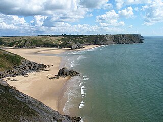
Three Cliffs Bay, otherwise Three Cliff Bay, is a bay on the south coast of the Gower Peninsula in the City and County of Swansea, Wales. The bay takes its name from the three sea cliffs that jut out into the bay. Pennard Pill, a large stream, flows into the sea in the middle of the bay.

Oxwich Bay is a bay on the south of the Gower Peninsula, Wales.
Slade Bay - marked on Ordnance Survey maps as "The Sands" - is a sandy beach near the village of Slade, on the Gower Peninsula in South West Wales. It is set in a relatively inaccessible location - being reachable only on foot and climbing over some large rocks. At the back of the beach, worked fields and steep gorse-clad cliffs are visible.

Bishopston is a large village and community situated on the Gower Peninsula, 6 miles (9.7 km) west south west of the centre of Swansea in South Wales.

The River Gwendraeth is a river in Carmarthenshire in West Wales.
The Millennium Coastal Park was originally a project undertaken by Llanelli Borough Council to transform a 12 miles stretch of industrial wasteland on the south Carmarthenshire coast into green parkland. The project was then taken over by Carmarthenshire County Council after the amalgamation of Welsh local authorities and the land was transformed into a landscaped recreational area for the general public. The park is 1000 hectares in area, cost £35 million to develop and in 2002 was awarded a Civic Trust Award. It has extensive views over the Lloughor Estuary to the Gower Peninsula. It includes a cycle track which provides traffic-free cycling and has been described as "one of the finest stretches of the whole National Cycle Network". Another feature is a wave-shaped, grass-covered landform, created from 115,000 cubic metres (4,100,000 cu ft) pulverised fuel ash, a form of "land art".

Caswell Bay, is a beach on the south east of the Gower Peninsula, Swansea, Wales. It is a sandy beach popular with families, holiday makers and surfers, and it regularly achieves Blue Flag status.
Bulmore or Bullmoor is a hamlet in the south-east of the Caerleon ward of the city of Newport, South Wales. The name is derived from the Welsh Y Pwll Mawr meaning The Large Pool. It was first settled by the Romans.

Whiteford Sands is a two-mile expanse of beach on the northern side of the Gower Peninsula, south Wales. It is the most northerly beach on Gower and sits on the edge of the Loughor estuary.
Brandy Cove is a very small beach in the Gower Peninsula, south Wales, that is much less accessible than Caswell Bay immediately to the east. It is set at the end of a valley from Bishopston village. It is reachable by footpath from Bishopston or from Caswell Bay over some steep cliffs. The bay gets its name from stories of smugglers using the bay to unload their illegal tobacco and alcohol goods during the eighteenth century.
Rotherslade is a small stretch of sandy beach at the eastern end of Langland Bay in the south Gower Peninsula, Wales. Previously known as 'Little Langland', it only exists as a separate beach at high tide. At low tide it is continuous with Langland Bay.
Hunts Bay is located on the south coast of the Gower Peninsula, Wales, between Pwll du and Foxhole to the east of Three Cliffs Bay. It was once a sandy beach, but the sand depth on the beach is diminishing, leaving a rocky cove. The loss of sand has been attributed to sand dredging in the local coastal area.

Mewslade Bay is a small sandy beach facing SSW in the west of the Gower Peninsula, Wales. It lies south of Middleton and southwest of Pitton, from which footpaths lead to the beach.

Blue Pool Bay is a small cove near the village of Llangennith in Gower, Wales. The cove is bordered by cliffs, and is accessible via a clifftop path and a steep, unstable path down to the beach. The beach is covered fully at high tide and takes its name from a large, natural rockpool. Rhossili Bay is nearby.

The Gower and Swansea Bay Coast Path is part of the Wales Coast Path, an 1,400-kilometre (870 mi) long-distance walking route around the whole coast of Wales that opened in 2012. The Gower and Swansea Bay stretch is 156 kilometres (97 mi) in length, running along the coast of the Gower Peninsula from Loughor, Swansea to Kenfig Dunes near Port Talbot, South Wales. The number of people using the Wales Coast Path in the Swansea local authority area was 349,333.

Pwll Du was a village in Monmouthshire, Wales. It was declared a slum in 1960 and demolished in 1963. The main employment was provided by nearby limestone quarries and by the iron works in Blaenavon. The Pwll Du Tunnel from Blaenavon, once the longest horse-powered tramway in Britain, ended near the village. A pub and the former Welfare Hall, now a school's outdoor pursuits centre, are all that are left standing.


