
Gower or the Gower Peninsula is in South West Wales and is the most westerly part of the historic county of Glamorgan, Wales. It projects towards the Bristol Channel. In 1956, the majority of Gower became the first area in the United Kingdom to be designated an Area of Outstanding Natural Beauty.

The Bristol Channel is a major inlet in the island of Great Britain, separating South Wales and South West England. It extends from the smaller Severn Estuary of the River Severn to the North Atlantic Ocean. It takes its name from the English city and port of Bristol.

Swansea Bay is a bay on the southern coast of Wales. The River Neath, River Tawe, River Afan, River Kenfig and Clyne River flow into the bay. Swansea Bay and the upper reaches of the Bristol Channel experience a large tidal range. The shipping ports in Swansea Bay are Swansea Docks, Port Talbot Docks and Briton Ferry wharfs.

Three Cliffs Bay, otherwise Three Cliff Bay, is a bay on the south coast of the Gower Peninsula in the City and County of Swansea, Wales. The bay takes its name from the three sea cliffs that jut out into the bay. Pennard Pill, a large stream, flows into the sea in the middle of the bay.

Rhossili is both a small village and a community on the southwestern tip of the Gower Peninsula in Wales. It is within the first Area of Outstanding Natural Beauty in the United Kingdom. The village has a community council and is part of the Gower parliamentary constituency, and the Gower electoral ward. At the 2011 census, the population was 278. The community includes the hamlet of Middleton.

Oxwich Bay is a bay on the south of the Gower Peninsula, Wales.
The River Loughor is a river in Wales which marks the border between Carmarthenshire and Swansea. The river is sourced from an underground lake at the Black Mountain emerging at the surface from Llygad Llwchwr which translates from the Welsh as "eye of the Loughor". It flows past Ammanford and Hendy in Carmarthenshire and Pontarddulais in Swansea. The river divides Carmarthenshire from Swansea for much of its course and it separates Hendy from Pontarddulais at the point where the river becomes tidal. The Loughor meets the sea at its estuary near the town of Loughor where it separates the south coast of Carmarthenshire from the north coast of the Gower Peninsula. Among its tributaries is the River Amman and the River Morlais, with the former joining the Loughor near Pantyffynnon. The area of the catchment is some 262 square kilometres (101 sq mi).
Langland Bay is a popular coastal holiday resort in Gower, Swansea in south Wales. It is a popular surfing beach which regularly meets the European Blue Flag award for quality.

Broughton Bay is a beach of the Gower Peninsula, South Wales, located at the north western tip. The bay is backed by sand dunes further inland. Access to the adjacent Whiteford Sands beach to the west is only available at low tide.

Whiteford Sands is a two-mile expanse of beach on the northern side of the Gower Peninsula, south Wales. It is the most northerly beach on Gower and sits on the edge of the Loughor estuary.
Brandy Cove is a very small beach in the Gower Peninsula, south Wales, that is much less accessible than Caswell Bay immediately to the east. It is set at the end of a valley from Bishopston village. It is reachable by footpath from Bishopston or from Caswell Bay over some steep cliffs. The bay gets its name from stories of smugglers using the bay to unload their illegal tobacco and alcohol goods during the eighteenth century.
Mumbles Beach is a very small sheltered area of sand and rock pools sandwiched between Swansea Bay beach and Bracelet Bay in the south eastern corner of the Gower Peninsula, Swansea, Wales.
Limeslade Bay is a small cove just to the west of Bracelet Bay in the south east corner of the Gower Peninsula, near Swansea in south Wales. It is a sheltered, mainly rocky beach with little sand. Bathing is possible. There is a car park in the adjacent Bracelet Bay. From Limeslade Bay there is a cliff walk to Langland Bay, about half a mile to the west.
Rotherslade is a small stretch of sandy beach at the eastern end of Langland Bay in the south Gower Peninsula, Wales. Previously known as 'Little Langland', it only exists as a separate beach at high tide. At low tide it is continuous with Langland Bay.

Pwlldu Bay or Pwll Du Bay is a small beach on the south Gower Peninsula coast in south Wales. It is one of the more remote beaches and is not easily accessible by car, but there are several good footpaths leading to it.
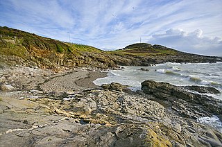
Hunts Bay is located on the south coast of the Gower Peninsula, Wales, between Pwll du and Foxhole to the east of Three Cliffs Bay. It was once a sandy beach, but the sand depth on the beach is diminishing, leaving a rocky cove. The loss of sand has been attributed to sand dredging in the local coastal area.

Plymouth Bay is a small, well-protected bay of the Atlantic Ocean on the western shore of larger Cape Cod Bay along the coastline of the Commonwealth of Massachusetts. Plymouth Bay retains historical significance for the landing at Plymouth Rock in 1620 by the Pilgrims aboard the Mayflower who proceeded to establish the first permanent Northern European settlement in North America at Plymouth Colony.

Horton Beach is located in Port Eynon Bay on the south coast of the Gower Peninsula in Wales.

Blue Pool Bay is a small cove near the village of Llangennith in Gower, Wales. The cove is bordered by cliffs, and is accessible via a clifftop path and a steep, unstable path down to the beach. The beach is covered fully at high tide and takes its name from a large, natural rockpool. Rhossili Bay is nearby.

