
Gower or the Gower Peninsula is in South West Wales and is the most westerly part of the historic county of Glamorgan, Wales. It projects towards the Bristol Channel. In 1956, the majority of Gower became the first area in the United Kingdom to be designated an Area of Outstanding Natural Beauty.

The Jurassic Coast is a World Heritage Site on the English Channel coast of southern England. It stretches from Exmouth in East Devon to Studland Bay in Dorset, a distance of about 96 miles (154 km), and was inscribed on the World Heritage List in mid-December 2001.

The South West Coast Path is England's longest waymarked long-distance footpath and a National Trail. It stretches for 630 miles (1,014 km), running from Minehead in Somerset, along the coasts of Devon and Cornwall, to Poole Harbour in Dorset. Because it rises and falls with every river mouth, it is also one of the more challenging trails. The total height climbed has been calculated to be 114,931 ft (35,031 m), almost four times the height of Mount Everest. It has been voted 'Britain's Best Walking route' twice in a row by readers of The Ramblers' Walk magazine, and regularly features in lists of the world's best walks.

The Bristol Channel is a major inlet in the island of Great Britain, separating South Wales and South West England. It extends from the smaller Severn Estuary of the River Severn to the North Atlantic Ocean. It takes its name from the English city and port of Bristol.

Pembrokeshire Coast National Park is a national park along the Pembrokeshire coast in west Wales.
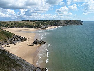
Three Cliffs Bay, otherwise Three Cliff Bay, is a bay on the south coast of the Gower Peninsula in the City and County of Swansea, Wales. The bay takes its name from the three sea cliffs that jut out into the bay. Pennard Pill, a large stream, flows into the sea in the middle of the bay.

Rhossili is both a small village and a community on the southwestern tip of the Gower Peninsula in Wales. It is within the first Area of Outstanding Natural Beauty in the United Kingdom. The village has a community council and is part of the Gower parliamentary constituency, and the Gower electoral ward. At the 2011 census, the population was 278. The community includes the hamlet of Middleton.

Oxwich Bay is a bay on the south of the Gower Peninsula, Wales.
Llangennith is a village in the City and County of Swansea, South Wales. It is located in the Gower. Moor Lane leads westwards to a caravan park near Rhossili Bay and Burrows Lane leads northwards to a caravan park overlooking Broughton Bay. The village has a scattering of houses, centred on St Cenydd's church, and the King's Head pub.

Treyarnon is a hamlet west of St Merryn in Cornwall, England, UK near Padstow. Treyarnon Beach is a small beach nearby with a caravan park, Youth Hostel and café.

Southerndown is a village in the Vale of Glamorgan, in south Wales. It is southwest of Bridgend, and within the St Brides Major community, close to Llantwit Major and Ogmore-by-Sea. It is mostly known for its beach which backs Dunraven Bay, which is a popular tourist destination during the summer months and since 1972 has been part of a Heritage Coast and is part of the Southerndown Coast SSSI. When the tide is out there is an expanse of sand and pools. The cliffs are an obvious example of sedimentary rock.
Langland Bay is a popular coastal holiday resort in Gower, Swansea in south Wales. It is a popular surfing beach which regularly meets the European Blue Flag award for quality.

Caswell Bay, is a beach on the south east of the Gower Peninsula, Swansea, Wales. It is a sandy beach popular with families, holiday makers and surfers, and it regularly achieves Blue Flag status.
Trebarwith Strand is a section of coastline located near the coastal settlement of Trebarwith on the north coast of Cornwall, England, UK, 2+1⁄2 miles (4.0 km) south of Tintagel. It has 800m of sandy beach contained by cliffs in which natural caves are found. The beach can only be accessed at low tide. The strand was once used to land ships to export slate from the nearby quarries while sand from the beach was used for agricultural purposes. The view from the beach is dominated by rocks 300m offshore known as Gull Rock or Otterham Rocks.

Whiteford Sands is a two-mile expanse of beach on the northern side of the Gower Peninsula, south Wales. It is the most northerly beach on Gower and sits on the edge of the Loughor estuary.
Brandy Cove is a very small beach in the Gower Peninsula, south Wales, that is much less accessible than Caswell Bay immediately to the east. It is set at the end of a valley from Bishopston village. It is reachable by footpath from Bishopston or from Caswell Bay over some steep cliffs. The bay gets its name from stories of smugglers using the bay to unload their illegal tobacco and alcohol goods during the eighteenth century.

Pwlldu Bay or Pwll Du Bay is a small beach on the south Gower Peninsula coast in south Wales. It is one of the more remote beaches and is not easily accessible by car, but there are several good footpaths leading to it.

Nash Point is a headland and beach in the Monknash Coast of the Vale of Glamorgan in south Wales, about a mile from Marcross. It is a popular location for ramblers and hiking along the cliffs to Llantwit Major beach. The lighthouse meadow is a Site of Special Scientific Interest, containing rare plants such as the tuberous thistle, and other wildlife such as choughs can be seen.

The coastline of Wales extends from the English border at Chepstow westwards to Pembrokeshire then north to Anglesey and back eastwards to the English border once again near Flint. Its character is determined by multiple factors, including the local geology and geological processes active during and subsequent to the last ice age, its relative exposure to or shelter from waves, tidal variation and the history of human settlement and development which varies considerably from one place to another. The majority of the coast east of Cardiff in the south, and of Llandudno in the north, is flat whilst that to the west is more typically backed by cliffs. The cliffs are a mix of sandstones, shales and limestones, the erosion of which provides material for beach deposits. Of the twenty-two principal areas which deliver local government in Wales, sixteen have a coastline, though that of Powys consists only of a short section of tidal river some distance from the open sea. Its length has been estimated at 1,680 miles (2,700 km).

