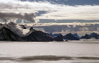
The Humboldt Mountains are a group of mountains immediately west of the Petermann Ranges, forming the westernmost portion of the Wohlthat Mountains in Queen Maud Land, Antarctica.
Mount Shute is a mountain (2,070 m) standing 14 miles (22 km) southeast of Austin Peak in Mirabito Range, Antarctica. Mapped by United States Geological Survey (USGS) from surveys and U.S. Navy air photos 1960 63. Named by Advisory Committee on Antarctic Names (US-ACAN) for Larry R. Shute, United States Antarctic Research Program (USARP) meteorologist at Hallett Station, 1963–64.

Austreskorve Glacier is a broad glacier in the Mühlig-Hofmann Mountains which drains north from a position just east of the head of Vestreskorve Glacier and passes along the east side of Breplogen Mountain. It was mapped and named from surveys and from air photos by the Sixth Norwegian Antarctic Expedition (1956–60).
Abolin Rock, also known as Skala Abolina, is a large rock outcrop lying 2 kilometres (1 nmi) west of the north end of Vindegga Spur in the Liebknecht Range, Humboldt Mountains, in Queen Maud Land. Discovered and plotted from air photos by Third German Antarctic Expedition, 1938–39. Mapped from air photos and surveys by Sixth Norwegian Antarctic Expedition, 1956–60; remapped by Soviet Antarctic Expedition, 1960–61, and named after Soviet botanist R.I. Abolin.
Bystrov Rock is a prominent rock lying 1 nautical mile (2 km) south-southeast of Isdalsegga Ridge in the Südliche Petermann Range of the Wohlthat Mountains. It was mapped from air photos and surveys by the Sixth Norwegian Antarctic Expedition, 1956–60; remapped by the Soviet Antarctic Expedition, 1960–61, and named after Soviet paleontologist A.P. Bystrov.
Vivaldi Glacier is a glacier lying between the Colbert Mountains and the Lully Foothills, flowing south from Purcell Snowfield into the head of Schubert Inlet on the west coast of Alexander Island, Antarctica. The feature appears to be first shown on maps of the United States Antarctic Service (USAS) which photographed Alexander Island from the air in 1940. It was mapped from air photos obtained by the Ronne Antarctic Research Expedition in 1947–48, by Searle of the Falkland Islands Dependencies Survey in 1960. Named "Vivaldi Gap" by the United Kingdom Antarctic Place-Names Committee in 1961, after Antonio Vivaldi (1678–1741), Venetian composer. The name was amended to Vivaldi Glacier following review of Landsat program imagery, 1979, displaying flow lines in the feature.
Kvamsgavlen Cliff is a gable-like cliff facing east at the southeast corner of Storkvammen Cirque, on the east side of the Humboldt Mountains in Queen Maud Land, Antarctica. It was discovered and photographed by the Third German Antarctic Expedition, 1938–39, and was mapped and named by Norway from air photos and surveys by the Sixth Norwegian Antarctic Expedition, 1956–60.
Pervomayskaya Peak is a peak, 2,795 m, standing 1 nautical mile (1.9 km) northeast of Mount Skarshovden in the central Humboldt Mountains, Queen Maud Land. Discovered and plotted from air photos by German Antarctic Expedition, 1938-39. Mapped from air photos and surveys by Norwegian Antarctic Expedition, 1956–60; remapped by Soviet Antarctic Expedition, 1960–61, and named Gora Pervomayskaya.
Pettersen Ridge is a ridge extending north for 6 nautical miles (11 km) from Sandho Heights in the Conrad Mountains of the Orvin Mountains, Queen Maud Land. Discovered and photographed by the German Antarctic Expedition, 1938-39. Mapped by Norway from surveys and air photos by the Norwegian Antarctic Expedition, 1956–60, and named for Sverre Pettersen, steward with the Norwegian Antarctic Expedition, 1957-58.
Mount Flånuten is a mountain 2,725 metres (8,940 ft) high extending as a massif between Livdebotnen Cirque and Vindegghallet Glacier, in the Humboldt Mountains of Queen Maud Land, Antarctica. It was discovered and photographed by the Third German Antarctic Expedition, 1938–39. It was mapped by Norway from air photos and surveys of the Sixth Norwegian Antarctic Expedition, 1956–60, and named Flånuten.
Migmatitovaya Rock is a rock at the eastern end of a spur, lying 3 nautical miles (6 km) northeast of Terletskiy Peak in the Shcherbakov Range of the Orvin Mountains, Queen Maud Land, Antarctica. It was roughly plotted from air photos by the Third German Antarctic Expedition, 1938–39, and was mapped from air photos and surveys by the Sixth Norwegian Antarctic Expedition, 1956–60. The feature was remapped by the Soviet Antarctic Expedition, 1960–61, and named "Skala Migmatitovaya".
Mount Mirotvortsev is a mountain, 2,830 metres (9,300 ft) high, standing 1.5 nautical miles (3 km) northeast of Mount Neustruyev in the Südliche Petermann Range of the Wohlthat Mountains, Antarctica. It was discovered and plotted from air photos by the Third German Antarctic Expedition in 1938–39, and was mapped from air photos and surveys by the Sixth Norwegian Antarctic Expedition, 1956–60. The mountain was remapped by the Soviet Antarctic Expedition in 1960–61, and named after K.N. Mirotvortsev (1880–1950), a Soviet geographer and explorer.
Sandhøkalvane Nunataks is a group of nunataks located 4 nautical miles (7.4 km) northeast of Sandhø Heights, lying between the Conrad Mountains and Mount Dallmann in Queen Maud Land. They were discovered and photographed by the German Antarctic Expedition in 1938-39, and mapped by Norway from air photos and surveys by the Norwegian Antarctic Expedition, 1956–60, and named Sandhøkalvane.
Sandegga Ridge is a ridge extending south for 5 nautical miles (9 km) from Sandho Heights in the Conrad Mountains of the Orvin Mountains, Queen Maud Land. Discovered and photographed by the German Antarctic Expedition, 1938-39. Mapped by Norway from air photos and surveys by Norwegian Antarctic Expedition, 1956–60, and named Sandegga.
Skarsbrotet Glacier is a cirque-type glacier draining the east slopes of Skarshaugane Peaks, in the Humboldt Mountains of Queen Maud Land. Discovered and photographed by the German Antarctic Expedition, 1938-39. Mapped by Norway from air photos and surveys by the Norwegian Antarctic Expedition, 1956–60, and named Skarsbrotet.
Skeidshornet Peak is a peak, 2,725 m, standing 5 nautical miles (9 km) west-southwest of Mount Valikhanov in the Pieck Range of the Petermann Ranges, in Queen Maud Land. Discovered and plotted from air photos by German Antarctic Expedition, 1938-39. Replotted from air photos and surveys by Norwegian Antarctic Expedition, 1956–60, and named Skeidshornet.
Hovdeskar Gap is a gap just east of Mount Skarshovden at the head of Skarsbrotet Glacier, in the Humboldt Mountains of Queen Maud Land, Antarctica. It was discovered and photographed by the Third German Antarctic Expedition, 1938–39, was mapped by Norway from air photos and surveys by the Sixth Norwegian Antarctic Expedition, 1956–60, and named Hovdeskar.
Kal'vets Rock is a rock outcrop lying 2 nautical miles (4 km) west-southwest of the summit of Mount Flånuten on the west side of the Humboldt Mountains, Queen Maud Land, Antarctica. It was discovered and plotted from air photos by the Third German Antarctic Expedition, 1938–39, and mapped from air photos and surveys by the Sixth Norwegian Antarctic Expedition, 1956–60. It was remapped by the Soviet Antarctic Expedition, 1960–61, and named after Soviet pilot O.A. Kal'vets.
Luna-Devyat' Mountain is a mountain, 1,880 metres (6,170 ft) high, forming the eastern end of the Eidshaugane Peaks in the Humboldt Mountains of Queen Maud Land, Antarctica. It was discovered and plotted from air photos by the Third German Antarctic Expedition, 1938–39, and was mapped from air photos and surveys by the Sixth Norwegian Antarctic Expedition, 1956–60. It was remapped by the Soviet Antarctic Expedition, 1960–61, and named "Gora Luna-Devyat'" in commemoration of the achievements of Soviet scientists in the study of space.