Åraksbø is a village in Bygland municipality in Aust-Agder county, Norway. The village is located on the eastern shore of the Åraksfjorden, about 5 kilometres (3.1 mi) north of the village of Sandnes and about 6 kilometres (3.7 mi) southeast of the village of Ose. The population (2001) of the Åraksbø area was 89.

Byglandsfjord is a village in Bygland municipality in Aust-Agder county, Norway. The village is located in the Setesdal valley along the Norwegian National Road 9 and the river Otra in the far southern part of the municipality, just north of the border with Evje og Hornnes municipality and at the southern end of the lake Byglandsfjorden. The 0.47-square-kilometre (120-acre) village has a population (2016) of 365 which gives the village a population density of 777 inhabitants per square kilometre (2,010/sq mi).

Topsæ is a lake in the municipality of Bygland in Aust-Agder county, Norway. The 2.4-square-kilometre (0.93 sq mi) lake is located 3 kilometres (1.9 mi) east of the lake Hovatn, about 10 kilometres (6.2 mi) northeast of the village of Åraksbø. The Topsæfossen waterfall is located at the north end of the lake at the primary inflow. At the southeastern corner of the lake, there is a small dam to regulate the outflow of the lake into the Tovdalselva watershed.
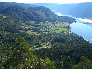
Åraksfjorden is a lake in the municipality of Bygland in Aust-Agder county, Norway. The 11.96-square-kilometre (4.62 sq mi) lake is part of the Otra drainage basin. The northern part of the lake is fed directly by the river Otra. The southern part of the lake goes through a narrow channel which leads into the Byglandsfjorden. The villages of Frøysnes and Skåmedal are located along the western side of the lake and on the eastern side are the villages of Sandnes and Åraksbø. The Norwegian National Road 9 runs along the eastern side of the lake.
Øyarvatnet or Øyarvatn is a lake in Norway. It sits on the border between the municipalities of Valle in Aust-Agder county and Sirdal in Vest-Agder county, about 30 kilometres (19 mi) northeast of the village of Lunde, Sirdal and about 32 kilometres (20 mi) west of Austad in Bygland. The lake is part of the Kvina river system. It is located just to the south of the lake Rosskreppfjorden, which flows into it. The dam at the south end of the 8.05-square-kilometre (3.11 sq mi) lake keeps it at an elevation of 837 metres (2,746 ft).
Longerakvatnet or Longeraksvatnet is a lake in the municipality of Bygland in Aust-Agder county, Norway. It has a small dam on the southwest side to regulate the water level for hydro-electric power generation at a plant located down the hill. The lake discharges into the Longeraksåni river which flows into the Byglandsfjorden near the village of Longerak. The 3.4-square-kilometre (1.3 sq mi) lake is located about 6 kilometres (3.7 mi) southeast of the village of Lauvdal and about 10 kilometres (6.2 mi) northeast of the village of Byglandsfjord.

Kvifjorden is a lake in Norway that straddles the borders of the municipalities of Sirdal and Kvinesdal in Vest-Agder county and Bygland in Aust-Agder county. The lake was created when a dam was built along the Kvina river.
Gyvatn is a lake in Norway. The lake straddles the borders of the three municipalities of Bygland and Evje og Hornnes and Åseral. The 4.62-square-kilometre (1.78 sq mi) lake is located about 8 kilometres (5.0 mi) northwest of the village of Byglandsfjord and the lake Byglandsfjorden and it is about 7 kilometres (4.3 mi) east of the village of Åknes in Åseral.

Hovatn or Hovatnet is a lake in the municipality of Bygland in Aust-Agder county, Norway. It is part of the Otra river drainage basin. The 6.85-square-kilometre (2.64 sq mi) lake is regulated and is used by the nearby Hovatn hydroelectric power plant. The dam has an outlet into the Hovassåni river which empties into the Åraksfjorden near Åraksbø.
Homstølvatnet or Eptevatn is a lake in the far western part of the municipality of Froland in Aust-Agder county, Norway. It is located about 12 kilometres (7.5 mi) east of the village of Byglandsfjord (in Bygland municipality) and about 16 kilometres (9.9 mi) northwest of the village of Mykland in Froland. The lake was expanded in 1973 when a dam was built at the south end of the lake Eptevatn for the purposes of hydroelectric power generation. The dam made the lake larger so that it now includes the formerly separate lake Homstølvatnet as one large lake. The lake is now 3.92-square-kilometre (1.51 sq mi) large and it holds about 44 cubic megametres (3.6×10¹⁶ acre⋅ft) as a reservoir for the power station.
Straumsfjorden or Straumfjorden is a lake that is located along the border of the municipalities of Bygland and Valle in Aust-Agder county, Norway. The lake has a dam on the south end which discharges into the Hjellevatn lake and eventually travels to the lake Topsæ and the Tovdalselva river drainage basin. The lake sits in the southeastern part of the municipality, about 11 kilometres (6.8 mi) southeast of the village of Rysstad and about 10 kilometres (6.2 mi) northeast of Besteland.
Lauvdal is a village in the municipality of Bygland in Aust-Agder county, Norway. It's located along the Norwegian National Road 9 on the east side of Byglandsfjorden. The village lies about 6 kilometres (3.7 mi) south of the village of Bygland and about the same distance north of the village of Longerak. The population (2001) was 41 residents. The lake Longerakvatnet is located about 6 kilometres (3.7 mi) southeast of the village.
Grendi is a village in Bygland municipality in Aust-Agder county, Norway. The village is located on the east side of the lake Byglandsfjorden in the south part of the municipality. Grendi sits along the Norwegian National Road 9 about 5 kilometres (3.1 mi) north of the village of Byglandsfjorden and about 6 kilometres (3.7 mi) south of the village of Longerak. Årdal Church is located in the village. In the early 1900s, a tuberculosis sanatorium was established in Grendi.
Litveit or Lidtveit is a village in Bygland municipality in Aust-Agder county, Norway. The village is located up in the hills about 3 kilometres (1.9 mi) northeast of the village of Åraksbø. The lake Hovatn lies about 2 kilometres (1.2 mi) northeast of Litveit.
Longerak is a village in Bygland municipality in Aust-Agder county, Norway. The village is located on the eastern shore of the lake Byglandsfjorden. The village sits along the Norwegian National Road 9, about 7 kilometres (4.3 mi) north of the village of Grendi and about 6 kilometres (3.7 mi) south of Lauvdal. The village of Frøyrak lies about 2 kilometres (1.2 mi) to the west on the other side of the lake. The lake Longerakvatnet lies about 2.5 kilometres (1.6 mi) to the east, high up in the mountains above the village. The water from the lake is used in the Longerak power station to produce hydroelectric power.

Ose is a village in Bygland municipality in Aust-Agder county, Norway. The village is located along the river Otra, just north of the lake Åraksfjorden. The Norwegian National Road 9 runs through the village. Just across the river to the north lies the village of Austad, and about 1.5 kilometres (0.93 mi) to the north along Highway 9 lies the village of Moi.
Skåmedal is a village in Bygland municipality in Aust-Agder county, Norway. The village is located along the southwestern shore of the Åraksfjorden, about 2 kilometres (1.2 mi) southwest of the village of Sandnes, across the lake. Skåmedal sits along the Norwegian National Road 9, about 9 kilometres (5.6 mi) northwest of the village of Bygland and about 10 kilometres (6.2 mi) south of the village of Ose.
Bygland is the administrative centre of Bygland municipality in Aust-Agder county, Norway. The village is located on the eastern shore of the lake Byglandsfjorden, near the northern end of the lake. The village lies along the Norwegian National Road 9, about 6 kilometres (3.7 mi) north of the village of Lauvdal and about 8 kilometres (5.0 mi) southeast of the village of Skåmedal. The village is the site of the municipal government, old-age home, medical clinic, and Bygland Church. There is a private Christian high school, KVS Bygland, that is located in this village.


