Related Research Articles

Penn Hills is a township with home rule status in Allegheny County, Pennsylvania, United States. The population as of the 2010 census was 42,329. Penn Hills is the second-largest municipality in Allegheny County, after the city of Pittsburgh.

Bethel Township is a township in Armstrong County, Pennsylvania, United States. The population was 1,096 at the 2020 census, a decrease from 1,183 at the 2010 census.

Greenwood Township is a township in Crawford County, Pennsylvania, United States. The population was 1,431 at the 2020 census, down from 1,454 at the 2010 census.

Hayfield Township is a township in Crawford County, Pennsylvania, United States. The population was 2,781 at the 2020 census, down from 2,940 at the 2010 census.

Ringgold Township is a township in Jefferson County, Pennsylvania, United States. The population was 771 at the 2020 census.

Washington Township is a township in Jefferson County, Pennsylvania, United States. The population was 1,890 at the 2020 census. It was named for President George Washington.
Brokenstraw Creek is a 37.1-mile (59.7 km) tributary of the Allegheny River in Warren County, Pennsylvania in the United States.
East Sandy Creek is a tributary of the Allegheny River in Northwestern Pennsylvania in the United States.

Pithole Creek is a 17.1-mile (27.5 km) tributary of the Allegheny River in Northwest Pennsylvania in the United States. It has a drainage area of 41.8 square miles (108 km2).
Little Wills Creek is a 16.3-mile-long (26.2 km) tributary of Wills Creek in Bedford County, Pennsylvania, in the United States.

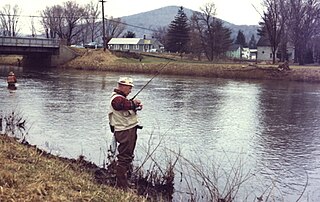
Oil Creek is a 46.7-mile (75.2 km) tributary of the Allegheny River in Venango and Crawford counties in the U.S. state of Pennsylvania. It has a drainage area of 319 square miles (830 km2) and joins the Allegheny at Oil City. Attractions along the river include the Drake Well Museum and Oil Creek State Park. The stream was named after the oil that was found along its banks before the historic oil strike by Edwin Drake in Titusville, which Oil Creek flows through. Oil Creek is popular with canoeists and fishers. The creek is rated as a beginners creek for those interested in learning how to safely use canoes and kayaks. Oil Creek is a cold water fishery with bass and trout living in its waters.

Conewago Creek is an 80.2-mile-long (129.1 km) tributary of the Susquehanna River in Adams and York counties in Pennsylvania in the United States, with its watershed also draining a small portion of Carroll County, Maryland. The source is at an elevation of 1,440 feet (440 m), east of Caledonia State Park, in Franklin Township in Adams County. The mouth is the confluence with the Susquehanna River at York Haven in York County at an elevation of 259 feet (79 m).
Potato Creek is a tributary of the Allegheny River in McKean County, Pennsylvania in the United States.

Kinzua Creek is a 26.5-mile (42.6 km) tributary of the Allegheny River in McKean County, Pennsylvania in the United States.

Sinnemahoning Creek is a 15.7-mile-long (25.3 km) tributary of the West Branch Susquehanna River in Cameron and Clinton counties, Pennsylvania, in the United States.

Tionesta Creek is a tributary of the Allegheny River in Forest, Clarion, Warren, McKean, and Elk Counties in Pennsylvania in the United States. Together with its West Branch, Tionesta Creek is 61.9 miles (99.6 km) long, flows generally south, and its watershed is 480 square miles (1,243 km2) in area.
Chest Creek is a tributary of the West Branch Susquehanna River in Cambria County and Clearfield County, in Pennsylvania, in the United States. It is approximately 40.4 miles (65.0 km) long and flows through Allegheny Township, East Carroll Township, Clearfield Township, Patton, Chest Township, and Elder Township in Cambria County and Westover Township, Chest Township, Newburg, Bell Township, and Mahaffey in Clearfield County. Although it is considered by the Pennsylvania Department of Environmental Protection to be impaired by situation, it is a coldwater fishery or a high-quality coldwater fishery throughout its length. The watershed of the creek has an area of 129.22 square miles (334.7 km2).
Drury Run is a tributary of the West Branch Susquehanna River in Clinton County, Pennsylvania, in the United States. It is 7.71 miles (12.41 km) long and its watershed is 11.5 square miles in area, most of which is forest. The stream's tributaries are affected by acid mine drainage, as are the lower reaches of the stream itself. It begins in Tamarack Swamp and flows through Leidy Township, Noyes Township, and Renovo. Brook trout, brown trout, creek chub, and eastern blacknose dace all inhabit the stream.
The Pennsylvania State Game Lands Number 31 are Pennsylvania State Game Lands in Jefferson County in Pennsylvania in the United States providing hunting, bird watching, and other activities.
References
- ↑ Shaw, Lewis C. Pennsylvania Gazetteer of Streams Part II (Water Resources Bulletin No. 16). Prepared in Cooperation with the United States Department of the Interior Geological Survey (1st ed.). Harrisburg, PA: Commonwealth of Pennsylvania, Department of Environmental Resources (no ISBN).
Coordinates: 41°21′43″N79°55′01″W / 41.36186°N 79.91688°W
| | This Venango County, Pennsylvania state location article is a stub. You can help Wikipedia by expanding it. |
| | This Mercer County, Pennsylvania state location article is a stub. You can help Wikipedia by expanding it. |
| | This Crawford County, Pennsylvania state location article is a stub. You can help Wikipedia by expanding it. |