
Anguilla is an island in the Leeward Islands. It has numerous bays, including Barnes, Little, Rendezvous, Shoal, and Road Bays.

The Florida Keys are a coral cay archipelago off the southern coast of Florida, forming the southernmost part of the continental United States. They begin at the southeastern coast of the Florida peninsula, about 15 miles (24 km) south of Miami and extend in a gentle arc south-southwest and then westward to Key West, the westernmost of the inhabited islands, and on to the uninhabited Dry Tortugas. The islands lie along the Florida Straits, dividing the Atlantic Ocean to the east from the Gulf of Mexico to the northwest, and defining one edge of Florida Bay. The southern part of Key West is 93 miles (150 km) from Cuba. The Keys are located between about 24.3 and 25.5 degrees North latitude.

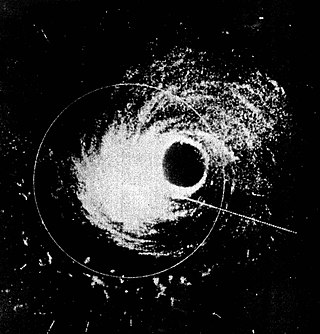
The 1938 New England Hurricane was one of the deadliest and most destructive tropical cyclones to strike the United States. The storm formed near the coast of Africa on September 9, becoming a Category 5 hurricane on the Saffir–Simpson hurricane scale, before making landfall as a Category 3 hurricane on Long Island on Wednesday, September 21. It is estimated that the hurricane killed 682 people, damaged or destroyed more than 57,000 homes, and caused property losses estimated at $306 million. Also, numerous others estimate the real damage between $347 million and almost $410 million. Damaged trees and buildings were still seen in the affected areas as late as 1951. It remains the most powerful and deadliest hurricane to ever strike New York and New England in history, perhaps eclipsed in landfall intensity only by the Great Colonial Hurricane of 1635.

Hurricane Donna, known in Puerto Rico as Hurricane San Lorenzo, was the strongest hurricane of the 1960 Atlantic hurricane season, and caused severe damage to the Lesser Antilles, the Greater Antilles, and the East Coast of the United States, especially Florida, in August–September. The fifth tropical cyclone, third hurricane, and first major hurricane of the season, Donna developed south of Cape Verde on August 29, spawned by a tropical wave to which 63 deaths from a plane crash in Senegal were attributed. The depression strengthened into Tropical Storm Donna by the following day. Donna moved west-northwestward at roughly 20 mph (32 km/h) and by September 1, it reached hurricane status. Over the next three days, Donna deepened significantly and reached maximum sustained winds of 130 mph (210 km/h) on September 4. Thereafter, it maintained intensity as it struck the Lesser Antilles later that day. On Sint Maarten, the storm left a quarter of the island's population homeless and killed seven people. An additional five deaths were reported in Anguilla, and there were seven other fatalities throughout the Virgin Islands. In Puerto Rico, severe flash flooding led to 107 fatalities, 85 of them in Humacao alone.

Hurricane Jeanne was the deadliest tropical cyclone in the Atlantic basin since Mitch in 1998, and the deadliest tropical cyclone worldwide in 2004. It was the tenth named storm, the seventh hurricane, and the fifth major hurricane of the season, as well as the third hurricane and fourth named storm of the season to make landfall in Florida. After wreaking havoc on Hispaniola, Jeanne struggled to reorganize, eventually strengthening and performing a complete loop over the open Atlantic. It headed westwards, strengthening into a Category 3 hurricane and passing over the islands of Great Abaco and Grand Bahama in the Bahamas on September 25. Jeanne made landfall later in the day in Florida just two miles from where Hurricane Frances had struck a mere three weeks earlier.
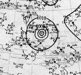
Hurricane Hattie was the strongest and deadliest tropical cyclone of the 1961 Atlantic hurricane season, reaching peak intensity as a Category 5 hurricane. The ninth tropical storm, seventh hurricane, fifth major hurricane, and second Category 5 of the season, Hattie originated from an area of low pressure that strengthened into a tropical storm over the southwestern Caribbean Sea on October 27. Moving generally northward, the storm quickly became a hurricane and later major hurricane the following day. Hattie then turned westward west of Jamaica and strengthened into a Category 5 hurricane, with maximum sustained winds of 165 mph (270 km/h). It weakened to Category 4 before making landfall south of Belize City on October 31. The storm turned southwestward and weakened rapidly over the mountainous terrain of Central America, dissipating on November 1.

Hurricane David was a devastating Atlantic hurricane which caused massive loss of life in the Dominican Republic in August 1979, and was the most intense hurricane to make landfall in the country in recorded history. A long-lived Cape Verde hurricane, David was the fourth named storm, second hurricane, and first major hurricane of the 1979 Atlantic hurricane season.

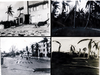
The Great Miami Hurricane of 1926 was a large and intense tropical cyclone that devastated the Greater Miami area of Florida and caused catastrophic damage in the Bahamas and the U.S. Gulf Coast in September 1926, accruing a US$100 million damage toll. The devastation wrought by the hurricane resulted in the end of Florida's land boom, and represented an early start to the Great Depression in the state. It has been estimated that a similar hurricane would cause about $235 billion in damage if it were to hit Miami in 2018.

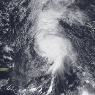
The Okeechobee hurricane of 1928, also known as the San Felipe Segundo hurricane, was one of the deadliest hurricanes in the recorded history of the North Atlantic basin, and the fourth deadliest hurricane in the United States, only behind the 1900 Galveston hurricane, 1899 San Ciriaco hurricane, and Hurricane Maria. The hurricane killed an estimated 2,500 people in the United States; most of the fatalities occurred in the state of Florida, particularly in Lake Okeechobee. It was the fourth tropical cyclone, third hurricane, the only major hurricane of the 1928 Atlantic hurricane season, and remains the deadliest disaster in Florida’s history to date. It developed off the west coast of Africa on September 6 as a tropical depression, but it strengthened into a tropical storm later that day, shortly before passing south of the Cape Verde islands. Further intensification was slow and halted late on September 7. About 48 hours later, the storm strengthened and became a Category 1 hurricane on the Saffir–Simpson hurricane wind scale. Still moving westward, the system reached Category 4 intensity before striking Guadeloupe on September 12, where it brought great destruction and resulted in 1,200 deaths. The islands of Martinique, Montserrat, and Nevis also reported damage and fatalities, but not nearly as severe as in Guadeloupe.

Hurricane Alice is the only known Atlantic hurricane to span two calendar years and one of only two named Atlantic tropical cyclones, along with Tropical Storm Zeta of 2005, to do so. The twelfth tropical cyclone and the eighth hurricane of the 1954 Atlantic hurricane season, Alice developed on December 30, 1954, from a trough of low pressure in the central Atlantic Ocean in an area of unusually favorable conditions. The storm moved southwestward and gradually strengthened to reach hurricane status. After passing through the Leeward Islands on January 2, 1955, Alice reached peak winds of 90 mph (140 km/h) before encountering cold air and turning to the southeast. It dissipated on January 6 over the southeastern Caribbean Sea.

The 1846 Havana hurricane was the most intense tropical cyclone in recorded history for 78 years and the first known Category 5-strength hurricane to strike Cuba. The first indications of the formation of a disturbance were first noted on 5 October in the Caribbean Sea, but little else was known until the storm approached Cuba on 10 October. There, it brought extreme winds and the lowest known atmospheric pressure of the time – 938 millibars (27.7 inHg) – a record which remained unbroken until the development of a later cyclone in 1924. It soon curved toward Florida, where it maintained its intensity, continuing to rapidly hasten northward along the East Coast of the United States to New England. It entered an extratropical transition while situated over New York on 13 October, producing intense Category 2-force winds and unusually little precipitation. Eventually, the gale dissipated over the Canadian Maritimes the following day as a markedly weaker storm.
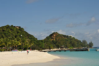
Palm Island in the Grenadines is a small island one mile from Union Island, only accessible by boat. It has an area of 135 acres (0.55 km2) and has five beaches.
The 1929 Bahamas hurricane was a high-end Category 4 tropical cyclone whose intensity and slow forward speed led to catastrophic damage in the Bahamas in September 1929, particularly on Andros and New Providence islands. Its erratic path and a lack of nearby weather observations made the hurricane difficult to locate and forecast. The storm later made two landfalls in Florida, killing eleven but causing comparatively light damage. Moisture from the storm led to extensive flooding over the Southeastern United States, particularly along the Savannah River. Across its path from the Bahamas to the mouth of the Saint Lawrence River, the hurricane killed 155 people.
The Tampa Bay hurricane of 1921 was a destructive and deadly major hurricane which made landfall in the Tampa Bay area of Florida in late October 1921. The eleventh tropical cyclone, sixth tropical storm, and fifth hurricane of the season, the storm developed from a trough in the southwestern Caribbean Sea on October 20. Initially a tropical storm, the system moved northwestward and intensified into a hurricane on October 22 and a major hurricane by October 23. Later that day, the hurricane peaked as a Category 4 on the modern day Saffir–Simpson scale with maximum sustained winds of 140 mph (230 km/h). After entering the Gulf of Mexico, the hurricane gradually curved northeastward and weakened to a Category 3 before making landfall near Tarpon Springs, Florida, late on October 25. It was the first major hurricane to make landfall in the Tampa Bay area since the hurricane of 1848 and was the last to date until Hurricane Milton in October 2024. The storm weakened to a Category 1 hurricane while crossing the Florida peninsula, and it reached the Atlantic Ocean early the following day. Thereafter, the system moved east-southeastward and remained fairly steady in intensity before weakening to a tropical storm late on October 29. The storm was then absorbed by a larger extratropical cyclone early the next day, with the remnants of the hurricane soon becoming indistinguishable.
Hurricane Klaus was a North Atlantic hurricane that hit the Leeward Islands from the west in November of the 1984 Atlantic hurricane season. Forming from a broad area of low pressure on November 5, Klaus maintained a northeast movement throughout much of its path. After making landfall on extreme eastern Puerto Rico, it passed to the north of the Leeward Islands, resulting in strong southwesterly winds and rough seas. Klaus attained hurricane status and reached peak winds of 90 mph (145 km/h) before becoming extratropical over cooler waters on November 13. The storm dropped heavy rainfall in Puerto Rico, causing minor flooding and light damage. Klaus caused heavy marine damage in the Leeward Islands, including wrecking at least three ships. The Virgin Islands experienced heavy damage as well.

Hurricane Wilma became one of the costliest tropical cyclones in Florida history. Wilma developed in the Caribbean Sea just southwest of Jamaica on October 15 from a large area of disturbed weather. After reaching tropical storm intensity on October 17 and then hurricane status on October 18, the system underwent explosive intensification, peaking as the strongest tropical cyclone ever recorded in the Atlantic basin. Wilma then slowly weakened while trekking to the northwest and fell to Category 4 intensity by the time it struck the Yucatán Peninsula on October 22. Thereafter, a strong cold front swept the storm northeastward into Florida on October 24, with landfall occurring near Cape Romano as a Category 3 hurricane with winds of 120 mph (190 km/h). Wilma continued rapidly northeastward into the Atlantic Ocean and became extratropical on October 26.
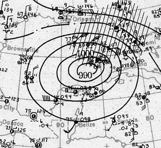
The 1947 Fort Lauderdale hurricane had widespread impacts in Florida. It produced significant flooding, damage to vegetation, and beach erosion in the Miami metropolitan area. After forming off West Africa on September 2, the storm moved on a parabolic path that brought it through The Bahamas as a Category 3 hurricane on September 16, eventually striking the city of Fort Lauderdale in South Florida as a powerful Category 4 hurricane on the following day. The hurricane later crossed the state, entered the Gulf of Mexico near Naples less than 24 hours later, and went on to strike Louisiana before dissipating on September 21.

The 1933 Treasure Coast hurricane was the second-most intense tropical cyclone to strike the United States during the active 1933 Atlantic hurricane season. The eleventh tropical storm, fifth hurricane, and the third major hurricane of the season, it formed east-northeast of the Leeward Islands on August 31. The tropical storm moved rapidly west-northwestward, steadily intensifying to a hurricane. It acquired peak winds of 140 mph (220 km/h) and passed over portions of the Bahamas on September 3, including Eleuthera and Harbour Island, causing severe damage to crops, buildings, and infrastructure. Winds over 100 mph (160 km/h) affected many islands in its path, especially those that encountered its center, and many wharves were ruined.

Hurricane Andrew was a tropical cyclone that struck the Bahamas, Florida, and Louisiana in August 1992. It is the most destructive hurricane to ever hit Florida in terms of structures damaged or destroyed, and remained the costliest in financial terms until Hurricane Irma surpassed it 25 years later. Andrew was also the strongest landfalling hurricane in the United States in decades and the costliest hurricane to strike anywhere in the country, until it was surpassed by Katrina in 2005.

Hurricane Sandy was an extremely large and devastating tropical cyclone which ravaged the Caribbean and the coastal Mid-Atlantic region of the United States in late October 2012. It was the largest Atlantic hurricane on record as measured by diameter, with tropical-storm-force winds spanning 1,150 miles (1,850 km). The storm inflicted nearly $70 billion USD in damage, and killed 254 people in eight countries, from the Caribbean to Canada. The eighteenth named storm, tenth hurricane, and second major hurricane of the 2012 Atlantic hurricane season, Sandy was a Category 3 storm at its peak intensity when it made landfall in Cuba, though most of the damage it caused was after it became a Category 1-equivalent extratropical cyclone off the coast of the Northeastern United States.


