
Gulf Islands National Park Reserve is a national park located on and around the Gulf Islands in British Columbia, Canada. In the National Parks System Plan, this park provides representation of the Strait of Georgia Lowlands natural region, the only place in Canada with a Mediterranean climate of dry, sunny summers and mild, wet winters, the result of a rain shadow effect from surrounding mountains between the region and the ocean. It has similar dominant vegetation as the Pacific Northwest, such as coastal Douglas-fir, western red cedar, shore pine, Pacific dogwood, bigleaf maple, and red alder, but also contains the northern extent of some of the more drought tolerant trees such as Garry oak and Arbutus. The park was created in 2003 as the fortieth national park. It covers 36 square kilometres (14 sq mi) of area on 16 islands and more than 30 islets, reefs and surrounding waters, making it the sixth smallest national park in Canada.

The Gulf Islands is a group of islands in the Salish Sea between Vancouver Island and the mainland coast of British Columbia.

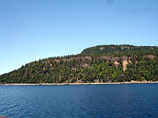
Galiano Island is one of the Southern Gulf Islands located between Vancouver Island and the Lower Mainland of British Columbia, Canada. Located on the west side of the Strait of Georgia, the island is bordered by Mayne Island to the southeast, Salt Spring Island to the west and Valdes Island to the northwest. Galiano is part of the Capital Regional District Electoral Area G, and has a permanent population of 1,396 inhabitants as of 2021.
Hornby Island of British Columbia, Canada, is one of the two northernmost Gulf Islands, the other being Denman Island. It is located near Vancouver Island's Comox Valley,

Denman Island,, is one of the Northern Gulf Islands and part of the Comox Valley Regional District of British Columbia, Canada. It is a member of the Islands Trust group of islands and is home to a small community of 1391 year-round residents.

Parts of this article have been adapted from the BC Parks website.
Boyle Point Provincial Park and Protected Area is a provincial park in British Columbia, Canada, located on the south end of Denman Island in the western Gulf of Georgia.
Apodaca Provincial Park is a provincial park located on the central eastern shoreline of Bowen Island, British Columbia, Canada.
Fillongley Provincial Park is a provincial park in British Columbia, Canada, located on the east side of Denman Island, southeast of Courtenay, British Columbia, and facing Georgia Strait.

Flores Island Marine Provincial Park, also known as Flores Island Provincial Park, is a provincial park in British Columbia, Canada, located on the island of the same name in the central Clayoquot Sound region of the West Coast of Vancouver Island, British Columbia, Canada. The park contains 7113 ha. and was created on July 13, 1995, as part of the Clayoqout Land-Use Decision. Gibson Marine Provincial Park, which was created in 1967, adjoins it to the southeast. Sulphur Passage Provincial Park is off the northeast coast of Flores Island, surrounding Obstruction Island.
Háthayim Marine Provincial Park, formerly Von Donop Marine Provincial Park, is a provincial park in British Columbia, Canada, located on the north end of Cortes Island in the Discovery Islands.

Helliwell Provincial Park is a provincial park in British Columbia, Canada located on a headland at the northeast end of Hornby Island.

Kitson Island Marine Provincial Park is a provincial park protecting all 45 hectares of Kitson Island and Kitson Islet. The park is located within the asserted traditional territory of the Tsimshian and Metlakatla First Nation, at the mouth of the Skeena River in British Columbia, Canada.

Klewnuggit Inlet Marine Provincial Park is a provincial park in British Columbia, Canada, located on the east side of Grenville Channel, 100 kilometres (62 mi) southeast of Prince Rupert, in the Range 4 Coast Land District.

Mitlenatch Island Nature Provincial Park is a provincial park in British Columbia, Canada encompassing Mitlenatch Island, a small islet in the northern Strait of Georgia within the Strathcona Regional District.
Union Passage Marine Provincial Park is a provincial park within the asserted traditional territory of the Tsimshian First Nations. The marine protected area is located at the southwest end of Grenville Channel straddling Pitt and Farrant Islands, in British Columbia, Canada.

Penrose Island Marine Provincial Park is a provincial park in the Central Coast region of British Columbia, Canada, located on the north side of the entrance to Rivers Inlet, 86 km north of Port Hardy at the south end of Fitz Hugh Sound. Comprising 1,079 hectares of marine area and 934 hectares of land area, the park is accessible by boat only and entrance to its anchorages are on its eastern side, the western being exposed to the open ocean. Exploration by dinghy and kayak are popular with visitors, as are nature viewing, scuba diving and exploring the islands many beaches and adjoining islets. The nearest supply centre for fuel and food is at the community of Rivers Inlet.

Nobby Islet is an islet located in the Great Australian Bight off the south coast of Kangaroo Island in the Australian state of South Australia approximately 50 kilometres south-west of Kingscote. It is currently part of the Seal Bay Conservation Park.

Checleset Bay is a bay on the northwest coast of Vancouver Island, British Columbia, Canada. It is located southeast of Brooks Peninsula and northwest of Kyuquot Sound. Much of the land around the bay is part of Brooks Peninsula Provincial Park. Checleset Bay has three large inlets, Nasparti Inlet, Ououkinsh Inlet, and Malksope Inlet.
Scott Islands Marine National Wildlife Area is a National Wildlife Area off the northwestern tip of Vancouver Island in the Canadian province of British Columbia. Covering an area of 11,570.65 km2 (4,467.45 sq mi), it is the second largest protected area in British Columbia after Offshore Pacific Seamounts and Vents Closure and is the largest national wildlife area in Canada.

