Sankt Josef

Last updated
Sankt Josef
Sankt Josef 01.jpg
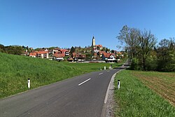
Sankt Josef seen from the west
AUT Sankt Josef (Weststeiermark) COA.jpg
Coat of arms
Austria adm location map.svg
Red pog.svg
Sankt Josef
Location within Austria
Coordinates: 46°54′37″N15°20′13″E / 46.91028°N 15.33694°E / 46.91028; 15.33694 Coordinates: 46°54′37″N15°20′13″E / 46.91028°N 15.33694°E / 46.91028; 15.33694
Country Austria
State Styria
District Deutschlandsberg
Government
   Mayor Franz Lindschinger (ÖVP)
Area
[1]
  Total13.3 km2 (5.1 sq mi)
Elevation
423 m (1,388 ft)
Population
 (2018-01-01) [2]
  Total1,601
  Density120/km2 (310/sq mi)
Time zone UTC+1 (CET)
  Summer (DST) UTC+2 (CEST)
Postal code
8503
Area code 03136
Vehicle registration DL
Website www.st-josef.
  steiermark.at/

Sankt Josef is a municipality in the district of Deutschlandsberg in the state of Styria in southeast Austria.

Styria State in Austria

Styria is a state, or Bundesland, located in the southeast of Austria. Covering 16,401 km2 (6,332 sq mi), Styria is the second largest of the nine component states of Austria, after Lower Austria. Styria's neighbor to the South is Slovenia. Within Austria, the contiguous states are Carinthia, Salzburg, Upper Austria, Lower Austria, and The Burgenland, The capital city is Graz, which had 276,526 inhabitants at the beginning of 2015.

Austria Federal republic in Central Europe

Austria, officially the Republic of Austria, is a land-locked country in Central Europe composed of nine federated states (Bundesländer), one of which is Vienna, Austria's capital and its largest city. Austria occupies an area of 83,879 km2 (32,386 sq mi) and has a population of nearly 9 million people. It is bordered by Germany and the Czech Republic to the north, Slovakia and Hungary to the east, Slovenia and Italy to the south, and Switzerland and Liechtenstein to the west. While German is the country's official language, many Austrians communicate informally in a variety of Bavarian dialects.

Contents

Population

Historical population
YearPop.±%
18691,215    
18801,313+8.1%
18901,317+0.3%
19001,268−3.7%
19101,226−3.3%
19231,295+5.6%
19341,263−2.5%
19391,141−9.7%
19511,189+4.2%
19611,062−10.7%
19711,136+7.0%
19811,161+2.2%
19911,176+1.3%
20011,337+13.7%
20111,353+1.2%

Related Research Articles

Ansfelden Place in Upper Austria, Austria

Ansfelden is a town in the Austrian state of Upper Austria. The rivers Traun and Krems run through the municipality. The town is perhaps best known for being the birthplace of the composer and organist Anton Bruckner.

Leoben Place in Styria, Austria

Leoben is a Styrian city in central Austria, located on the Mur river. With a population of about 25,000 it is a local industrial center and hosts the University of Leoben, which specialises in mining. The Peace of Leoben, an armistice between Austria and France preliminary to the Treaty of Campo Formio, was signed in Leoben in 1797.

Egg, Austria Place in Vorarlberg, Austria

Egg is a town in the Bregenz Forest in the Austrian state of Vorarlberg, part of the district of Bregenz.

Fürstenfeld Place in Styria, Austria

Fürstenfeld is a town and a district in southeastern Austria. It is situated within the Austrian federal state of Styria, near the border of Hungary.

Zwettl Place in Lower Austria, Austria

Zwettl is a town and district capital of the Austrian state of Lower Austria. It is chiefly known as the location of Zwettl Abbey, first mentioned in October 1139.

Kirchstetten Place in Lower Austria, Austria

Kirchstetten is a town in district of Sankt Pölten-Land in the Austrian state of Lower Austria.

Stockerau Place in Lower Austria, Austria

Stockerau is a town in the district of Korneuburg in Lower Austria, Austria. Stockerau has 15.921 Citizens, which makes it the largest town in the Weinviertel. Stockerau is also called "Lenaustadt" because the Austrian poet Nikolaus Lenau often spent time with his grandparents here.

Kirchdorf an der Krems Place in Upper Austria, Austria

Kirchdorf an der Krems is a town in the Austrian state of Upper Austria on the river Krems, in the district of Kirchdorf an der Krems. Apparently settled by the year 903,

Satteins Place in Vorarlberg, Austria

Satteins is a town in the Austrian state of Vorarlberg.

Ebreichsdorf Place in Lower Austria, Austria

Ebreichsdorf is a town in the district of Baden in Lower Austria in Austria.

Inzing Place in Tyrol, Austria

Inzing is a town in the Austrian Federal State Tyrol.

Gnadenwald Place in Tyrol, Austria

Gnadenwald is a municipality in the eastern part of the district Innsbruck country. The village consists of several hamlets and the church villages: St. Martin and St. Michael.

Holzgau Place in Tyrol, Austria

Holzgau is a municipality in the district of Reutte in the Austrian state of Tyrol.

Trofaiach Place in Styria, Austria

Trofaiach is a municipality in the Leoben district of the state of Styria in Austria, the site of a post World War II British sector displaced persons camp.

Großgmain Place in Salzburg, Austria

Großgmain is a municipality in the district of Salzburg-Umgebung in the state of Salzburg in Austria.

Langenrohr Place in Lower Austria, Austria

Langenrohr is a municipality in the district of Tulln in Lower Austria, Austria. The municipality has 2309 inhabitants as of 1 January 2013.

Hittisau Place in Vorarlberg, Austria

Hittisau is a municipality in the district of Bregenz in the Austrian state of Vorarlberg. Hittisau has a surface area of 46.65 km². It lies in the Bregenzerwald in the west of the country.

Waldhausen im Strudengau Place in Upper Austria, Austria

Waldhausen im Strudengau is a municipality in the district of Perg in the Austrian state of Upper Austria.

Taufkirchen an der Pram Place in Upper Austria, Austria

Taufkirchen an der Pram is a municipality in the district of Schärding in the Austrian state of Upper Austria.

Bad Waltersdorf Place in Styria, Austria

Bad Waltersdorf is a municipality in the district of Hartberg-Fürstenfeld in Styria, Austria.

References

  1. "Dauersiedlungsraum der Gemeinden Politischen Bezirke und Bundesländer - Gebietsstand 1.1.2018". Statistics Austria. Retrieved 10 March 2019.
  2. "Einwohnerzahl 1.1.2018 nach Gemeinden mit Status, Gebietsstand 1.1.2018". Statistics Austria. Retrieved 9 March 2019.