
The Santa Fe Trail was a 19th-century transportation route through central North America that connected Independence, Missouri with Santa Fe, New Mexico. Pioneered in 1821 by William Becknell, it served as a vital commercial highway until the introduction of the railroad to Santa Fe in 1880. Santa Fe was near the end of the El Camino Real de Tierra Adentro, which carried trade from Mexico City.

Aragon is an unincorporated community and census-designated place on the Tularosa River in Catron County, New Mexico, United States. As of the 2010 census it had a population of 94. It is located at an altitude of 7,135 feet (2,175 m), 7 miles (11 km) northeast of Apache Creek.

The Apache Wars were a series of armed conflicts between the United States Army and various Apache nations fought in the southwest between 1849 and 1886, though minor hostilities continued until as late as 1924. The United States inherited conflicts between American invaders and Apache groups when Mexico ceded territory after the Mexican–American War in 1846. These conflicts continued as new United States citizens came into traditional Apache lands to raise livestock, crops and to mine minerals.
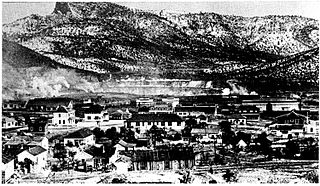
Santa Rita is a ghost town in Grant County in the U.S. state of New Mexico. The site of Chino copper mine, Santa Rita was located fifteen miles east of Silver City.

Mangas Coloradas or Mangus-Colorado, or Dasoda-hae was an Apache tribal chief and a member of the Mimbreño (Tchihende) division of the Central Apaches, whose homeland stretched west from the Rio Grande to include most of what is present-day southwestern New Mexico. He was the father-in-law of the Chiricahua (Tsokanende) Chief Cochise, the Mimbreño Chief Victorio and the Mescalero (Sehende) Chief Kutu-hala or Kutbhalla, and is regarded by many historians to be one of the most important Native American leaders of the 19th century due to his fighting achievements against the Mexicans and Americans.

Fort Bayard National Cemetery is a United States National Cemetery in the Fort Bayard Historic District, near Silver City, New Mexico. It encompasses 18.8 acres (7.6 ha), and as of the end of 2005, had 3,732 interments. It is one of two national cemeteries in New Mexico, and is administered by Santa Fe National Cemetery.

Lake Valley was a silver-mining town in Sierra County, U.S. state of New Mexico.
The Department of New Mexico was a department of the United States Army during the mid-19th century. It was created as the 9th Department, a geographical department, in 1848 following the successful conclusion of the Mexican–American War, and renamed Department of New Mexico in 1853. It had to contend with an invading Confederate force during the New Mexico Campaign of the American Civil War from mid-1861 to early 1862, then with Apache tribes during the remainder of the conflict. It was merged into the Department of California after the end of the war as the District of New Mexico.

Fort Cummings is a former U. S. Army post located near Cooke's Springs, in Luna County, New Mexico. It is located 20 miles northeast of Deming, New Mexico.

Presidio San Agustín del Tucsón was a presidio located within Tucson, Arizona. The original fortress was built by Spanish soldiers during the 18th century and was the founding structure of what became the city of Tucson. After the American arrival in 1856, the original walls were dismantled, with the last section torn down in 1918. A reconstruction of the northeast corner of the fort was completed in 2007 following an archaeological excavation that located the fort's northeast tower.
Fort Thorn or Fort Thorne, originally Cantonment Garland, was a settlement and military outpost located on the west bank of the Rio Grande, northwest of present-day Hatch, and west of Salem in Doña Ana County, New Mexico, United States. It was named for 1st Lt. Herman Thorn of the 2nd U.S. Infantry drowned in the Colorado River in 1849. He had previously been an aide to General John Garland, the new commander of the Ninth Military District, that encompassed New Mexico Territory in 1853.

Victorio's War, or the Victorio Campaign, was an armed conflict between the Apache followers of Chief Victorio, the United States, and Mexico beginning in September 1879. Faced with arrest and forcible relocation from his homeland in New Mexico to San Carlos Indian Reservation in southeastern Arizona, Victorio led a guerrilla war across southern New Mexico, west Texas and northern Mexico. Victorio fought many battles and skirmishes with the United States Army and raided several settlements until the Mexican Army killed him and most of his warriors in October 1880 in the Battle of Tres Castillos. After Victorio's death, his lieutenant Nana led a raid in 1881.
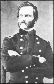
James Henry Carleton was an officer in the U.S. Army and a Union general during the American Civil War. Carleton is best known as an Indian fighter in the southwestern United States.
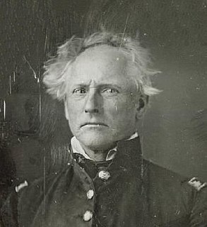
Enoch Steen was a United States military officer and western explorer. He joined the United States Army in 1832, serving at posts throughout the United States, including many remote locations in the west. During his military service, Steen explored parts of the western United States including large areas of southern New Mexico and southeastern Oregon. He served as the commander of several Union Army forts during the American Civil War. Today, there are landmarks in Oklahoma, Oregon, and New Mexico named in his honor; however, many of the place names are misspelled as Stein.
Baishan, Spanish name Cuchillo Negro, was a Tchihende (Mimbres) Apache chieftain, of the Warm Springs Apache Band during the 1830s to 1850s.

Camp Grant was the name used from 1866 to 1872 for the United States military post at the confluence of the San Pedro River and Aravaipa Creek in the Arizona Territory. It is near the site of the Camp Grant massacre.
Fort Webster, a fort located at two locations near Santa Rita and San Lorenzo in Grant County, New Mexico between 1851-1853 and 1859-1860.
Faywood Hot Springs is a resort in Grant County, New Mexico, United States. It is located 2 miles (3.2 km) northeast of US 180 and .5 miles (0.80 km) west of NM 61, just south of the City of Rocks State Park. The hot springs have been visited since the time of the Mimbres culture. It was a successful resort in the late 19th century and early 20th century. In 1952, the establishment was demolished and became a ghost town. The land was purchased in 1993 and developed into a hot springs resort again.
Fosters Hole or La Tinaja, was a waterhole on the original route of Cooke's Wagon Road in what is now Sierra County, New Mexico. It is located in narrow crevasse at the foot of a cliff in Jug Canyon that is difficult to spot, except from a few vantage points.


