Santa Terezinha (Coronel Fabriciano)

Last updated
Santa Terezinha
Neighborhood of Coronel Fabriciano
Vista parcial do B. Santa Terezinha, Coronel Fabriciano MG.JPG
View of the Santa Terezinha neighborhood
Brazil Minas Gerais location map.svg
Red pog.svg
Santa Terezinha
Location in Minas Gerais
Brazil location map.svg
Red pog.svg
Santa Terezinha
Santa Terezinha (Brazil)
Coordinates: 19°31′18″S42°37′11″W / 19.52167°S 42.61972°W / -19.52167; -42.61972
Country Flag of Brazil.svg  Brazil
State Minas Gerais
Municipality/City Coronel Fabriciano
ZoneSenador Melo Viana District
Area
  Total0.3 km2 (0.1 sq mi)
Population
  Total1 712
  Density5.316/km2 (13.77/sq mi)

Santa Terezinha or Santa Terezinha I is a neighborhood in the Brazilian municipality of Coronel Fabriciano, in the interior of the state of Minas Gerais. It is located in the Senador Melo Viana district, in Sector 1. According to the Brazilian Institute of Geography and Statistics (IBGE), its population in 2010 was 1 712 inhabitants (2.0% of the municipality's total), distributed over an area of 0.3 km2. [1] [2]

Contents

The neighborhood was created in the 1960s after the area, which belonged to former Mayor Rubem Siqueira Maia, was allotted. At the end of the 1980s, the Church of Saint Theresa was built and became one of the main venues for activities and events for the population. [3] [4]

History

In the middle of the 19th century, there was a small port at the mouth of the Caladão Stream, where goods and people were shipped to neighboring settlements via the Piracicaba River. At the end of the 1910s, when the Vitória-Minas Railway (EFVM) and the Calado Station were built, the population grew as workers settled in the area, forming the current central zone of Coronel Fabriciano. [4]

The area where the Santa Terezinha neighborhood is located, as well as the neighboring Santa Terezinha II and the region encompassed by the Aldeia do Lago and Mangueiras districts, belonged to the doctor Rubem Siqueira Maia, who was the first mayor of Coronel Fabriciano. The land was part of the Santa Terezinha Farm, named by Rubem and his daughter-in-law, Idalina Winter, after the saint of the same name. The site was allotted in 1964 by Imobiliária Santa Terezinha, owned by the Maia family, giving rise to the neighborhoods. [4]

In the 1980s, after the urban center had been consolidated, discussions began in favor of building a chapel. A plot of land was provided by the City Hall and the Church of Saint Theresa was built in 1988, through the donations and collective actions. The then parish priest, Father Élio Ataíde, donated the chairs for the church, which underwent renovations two decades later and was reopened in 2014. [4] [5]

Geography and demography

The Santa Terezinha neighborhood has a total area of 0.3 km2 and is bordered by Bom Jesus (to the north), Santa Helena (to the west), Caladinho, Aparecida do Norte (to the east) and Santa Terezinha II and the municipality of Timóteo (to the south). It covers the area where the Caladão Stream flows into the Piracicaba River. Although the neighborhood is bordered by the creek, flooding is not frequent in this stretch, as the accumulated water drains into the Piracicaba. There are trees on Julita Pires Bretas Avenue, which divides the Santa Terezinha and Santa Helena neighborhoods. In the upper part, landslides occasionally occur in areas on the edge of slopes. [6] [7] [8] [9] [10]

In 2010, the Brazilian Institute of Geography and Statistics (IBGE) estimated that 887 inhabitants lived in the neighborhood, which is comparable to cities in Minas Gerais such as São Sebastião do Rio Preto and Paiva. Among the 63 neighborhoods in Fabriciano, Santa Terezinha ranked 21th in terms of population, comprising 2.0% of the municipal population and 3.7% of the population of the Senador Melo Viana district, with a population density of 5,316.77 inhabitants per square kilometer. Of the total number of inhabitants, 809 were men (47.2% of the total) and 903 women (52.8%), distributed in 560 households. The Church of Saint Theresa is the headquarters of the Community of Santa Terezinha, whose Catholic pastoral work is subordinate to the Parish of Saint Sebastian, under the jurisdiction of the Diocese of Itabira-Fabriciano. [5] [2] [1]

Infrastructure and leisure

Caladao Stream between the Santa Helena and Santa Terezinha neighborhoods. Ribeirao Caladao entre os B. Santa Helena e Santa Terezinha, Coronel Fabriciano MG.JPG
Caladão Stream between the Santa Helena and Santa Terezinha neighborhoods.

The water supply service is provided by Companhia de Saneamento de Minas Gerais (Copasa), while the electricity supply is the responsibility of Companhia Energética de Minas Gerais (Cemig), with 100% of the population having access to the electricity network. There are schools and health facilities in the surrounding neighborhoods and in the central area of the city. No buses pass through the neighborhood, except on Rubem Siqueira Maia and Julita Pires Bretas avenues. [11] [12] [13]

The Church of Saint Theresa is one of the main buildings in the Santa Terezinha neighborhood. The Catholic community occasionally organizes leisure activities for the population, including typical food stalls and musical shows, as well as providing space for campaigns and events. The Feast of Saint Theresa, celebrated annually in October with processions, masses and special celebrations and a novena in honor of the community's patron saint, as well as concerts, is notable. The singing duo Leslie and Laurie, who performed for the first time in the church choir in 2008, stood out in musical performances around the city. In 2016, they were finalists in the first season of the Brazilian edition of The Voice Kids , a talent show promoted by Rede Globo. [5] [14] [15]

The Paulo Paulino Ribeiro Pitch, located next to the church, was restructured by the City Hall in 2008. It is named after a resident who developed social and sports work in the residential area and created the Náscoli, a local amateur soccer team. A 9 meter high image of the Divine Mercy was installed in the highest part of the neighborhood. The statue, installed by the Parish of Saint Sebastian in 2013, can be observed from different parts of downtown Fabriciano. [16] [17] [18]

See also

Related Research Articles

<span class="mw-page-title-main">Doce River</span> River in Brazil

The Doce River is a river in southeast Brazil with a length of 853 kilometres (530 mi). The river basin is economically important. In 2015, the collapse of a dam released highly contaminated water from mining into the river, causing an ecological disaster.

<span class="mw-page-title-main">Coronel Fabriciano</span> Municipality in Southeast, Brazil

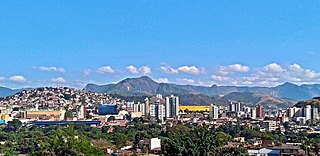
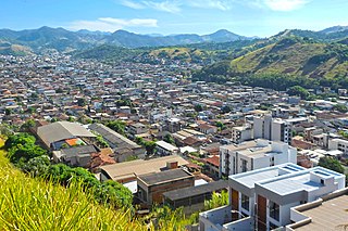
Coronel Fabriciano is a municipality in the state of Minas Gerais in the Southeast region of Brazil. It is located in the region of Vale do Rio Doce and is situated 200 km from the state capital. The municipal population was estimated in 2020 by IBGE in 110,290 inhabitants. The area is 221.252 km2 (85.426 sq mi).

<span class="mw-page-title-main">Antônio Dias</span> Brazilian municipality

Antônio Dias is a Brazilian municipality located in the state of Minas Gerais. Its population as of 2020 is estimated to be 9,275 people living in a total area of 877.844 km². The city belongs to the mesoregion of Vale do Rio Doce and to the microregion of Ipatinga.

<span class="mw-page-title-main">Vale do Aço metropolitan area</span> Metropolitan Area of Brazil in Southeast

The Vale do Aço Metropolitan Region is a metropolitan area in Minas Gerais, Brazil, comprising only the four municipalities of Coronel Fabriciano, Ipatinga, Santana do Paraíso and Timóteo, but have an influence area of 22 other municipalities.

<span class="mw-page-title-main">Serra dos Cocais</span> Mountain chain in Brazil

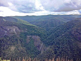
The Serra dos Cocais is a mountain chain located in the Brazilian municipality of Coronel Fabriciano, in the interior of the state of Minas Gerais. It is part of the geologic province of the Espinhaço mountains and is composed of continuous blocks of granite over 600 million years old. Its altitude, which reaches a high point of 1200 meters above sea level, stands out from the surrounding terrain with average altitudes ranging between 500 and 800 meters. It contains an important remnant of the Atlantic Forest, in the middle of considerable reforestation with eucalyptus, and has been considered an area of environmental protection since 2002.

Rubem Siqueira Maia was a Brazilian physician and politician. After living in São João del-Rei during his childhood and graduating from the School of Medicine of Federal University of Minas Gerais (UFMG), he moved to Vale do Rio Doce to work on the construction of the Vitória-Minas Railway (EFVM) in the 1930s.

<span class="mw-page-title-main">Saint Sebastian Cathedral, Coronel Fabriciano</span> Catholic religious temple in Brazil

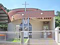
The Saint Sebastian Cathedral is a Catholic religious temple located in the Brazilian city of Coronel Fabriciano, in the interior of the state of Minas Gerais. It was inaugurated in 1993 and since then shares the title of seat of the Diocese of Itabira-Fabriciano with the Our Lady of the Rosary Cathedral, which also represents the Episcopal See, in Itabira.

<span class="mw-page-title-main">Saint Sebastian Parish, Coronel Fabriciano</span> Catholic Institution in Brazil

Saint Sebastian Parish is a division of the Catholic Church based in the Brazilian city of Coronel Fabriciano, in the interior of the state of Minas Gerais. The parish is part of the Diocese of Itabira-Fabriciano, and is located in Pastoral Region III. Its mother church is the Saint Sebastian Parish Church and its territory houses the co-cathedral of Saint Sebastian, which is one of the diocesan headquarters.

<span class="mw-page-title-main">Doutor José Maria Morais Hospital</span> Brazilian Hospital

Doutor José Maria Morais Hospital is an institution located in the Brazilian city of Coronel Fabriciano, in the interior of the state of Minas Gerais. It was created by Belgo-Mineira in 1936, due to an epidemic of tropical diseases that the town was facing at the time.

The Calado Station, also known as Coronel Fabriciano Station, was a railway station that operated as a passenger and loading and unloading terminal in the Brazilian municipality of Coronel Fabriciano, in the countryside of the state of Minas Gerais. It was inaugurated on June 9, 1924, being at the time one of the three largest stations of the Vitória-Minas Railway (EFVM). Around it was established the urban core that gave rise to the headquarters of the then-subordinated district to Antônio Dias, emancipated in 1948.

The history of Coronel Fabriciano, a Brazilian municipality in the interior of the state of Minas Gerais, began at the end of the 16th century. Expeditions followed the so-called Doce River Hinterlands in search of precious metals, however, the settlement of the region was forbidden at the beginning of the XVII century, to avoid smuggling of the gold extracted in the Diamantina region.

<span class="mw-page-title-main">Caladão Stream</span> Brazilian watercourse

The Caladão Stream is a watercourse that rises and flows in the Brazilian municipality of Coronel Fabriciano, in the state of Minas Gerais. The source is located in Serra dos Cocais and runs for 10 kilometers to its mouth in the Piracicaba River. Its sub-basin covers 53 km2 and encompasses the Senador Melo Viana district, the most populous area of the city.

<span class="mw-page-title-main">Giovannini (Coronel Fabriciano)</span> Brazilian neighborhood

iovannini is a neighborhood in the Brazilian municipality of Coronel Fabriciano, in the state of Minas Gerais. It is located in the Senador Melo Viana district, in Sector 4. According to the Brazilian Institute of Geography and Statistics (IBGE), its population in 2010 was 3,020, distributed over an area of 0.5 km2.

<span class="mw-page-title-main">Júlia Kubitschek (Coronel Fabriciano)</span> Brazilian neighborhood

Júlia Kubitschek, popularly known as JK, is a neighborhood in the Brazilian municipality of Coronel Fabriciano, in the interior of the state of Minas Gerais. It is located in the Senador Melo Viana district, in Sector 4. According to the Brazilian Institute of Geography and Statistics (IBGE), its population in 2010 was 3,452 inhabitants, distributed over an area of 1.4 km2.

<span class="mw-page-title-main">Professores (Coronel Fabriciano)</span> Brazilian neighborhood

Professores is a neighborhood in the Brazilian municipality of Coronel Fabriciano, in the interior of the state of Minas Gerais. It is located in the Senador Melo Viana district, in Sector 1. According to the Brazilian Institute of Geography and Statistics (IBGE), its population in 2010 was 887 inhabitants, distributed over an area of 0.1 km2.

<span class="mw-page-title-main">Centro (Coronel Fabriciano)</span> Brazilian neighborhood

Centro is a neighborhood in the Brazilian municipality of Coronel Fabriciano, in the interior of the state of Minas Gerais. It is located in the headquarters district, in Sector 1. According to the Brazilian Institute of Geography and Statistics (IBGE), its population in 2010 was 2,799 inhabitants, distributed over an area of 0.6 km2.

<span class="mw-page-title-main">Santa Helena (Coronel Fabriciano)</span> Brazilian neighborhood

Santa Helena is a neighborhood in the Brazilian municipality of Coronel Fabriciano, in the interior of the state of Minas Gerais. It is located in the headquarters district, in Sector 1. According to the Brazilian Institute of Geography and Statistics (IBGE), its population in 2010 was 1 359 inhabitants, distributed over an area of 0.2 km2.

<span class="mw-page-title-main">Floresta (Coronel Fabriciano)</span> Brazilian neighborhood

Floresta is a neighborhood in the Brazilian municipality of Coronel Fabriciano, in the interior of the state of Minas Gerais. It is located in the Senador Melo Viana district, in Sector 6. According to the Brazilian Institute of Geography and Statistics (IBGE), its population in 2010 was 2,820 inhabitants, distributed over an area of 0.4 km2.

<span class="mw-page-title-main">Caladinho Stream</span> Brazilian watercourse

The Caladinho Stream is a watercourse that rises and flows in the Brazilian municipality of Coronel Fabriciano, in the state of Minas Gerais. The source is located near the Caladinho neighborhood and it runs for about 12 kilometers to its mouth in the Piracicaba River through the Industrial Novo Reno, Universitário, Aparecida do Norte, Morada do Vale, Aldeia do Lago and Santa Terezinha II neighborhoods. Its sub-basin covers 9 km2.

<span class="mw-page-title-main">Pedro Nolasco Street</span> Street in Minas Gerais, Brazil

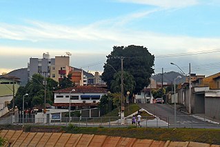
The Pedro Nolasco Street is located in the Brazilian municipality of Coronel Fabriciano, in the state of Minas Gerais. It begins at the intersection of Rio Piracicaba, Albert Scharlet, Doutor Querubino and Rubem Siqueira Maia streets and ends at São Sebastião Street. It originated in the 1920s when the old Calado Station was built on the site. Some of the buildings located on the street still retain their original architecture.

References

  1. 1 2 "Tabela 202 - População residente por sexo e situação do domicílio". IBGE. 2010-12-31.
  2. 1 2 "Sinopse por setores". IBGE. 2011-11-16.
  3. Gomes, Leonardo. "A origem dos nomes dos bairros de Coronel Fabriciano MG". Revista Nosso Vale. Archived from the original on 2014-03-22. Retrieved 2014-10-02.
  4. 1 2 3 4 "BAIRROS - SANTA TEREZINHA I E II". Eu Amo Ipatinga. Archived from the original on 26 Dec 2023. Retrieved 2023-12-27.
  5. 1 2 3 "Santa Teresinha". Paroquia São Sebastião. Retrieved 2023-12-28.
  6. "Expedição traça um retrato do Ribeirão Caladão". Coronel Fabriciano City Hall. 2009-10-19. Archived from the original on 2012-11-27. Retrieved 2012-02-08.
  7. "Após chuvas, Defesa Civil monitora áreas de risco em Fabriciano". G1. 2013-02-03. Retrieved 2023-12-28.
  8. "Defesa Civil de Fabriciano está em alerta para chuvas nos próximos dias". Coronel Fabriciano City Hall. Retrieved 2023-12-28.
  9. "Parque Linear avança". DIário do Aço. 2015-01-16. Retrieved 2023-12-28.
  10. Xavier, Marcia (2013-04-27). "Chuva faz volume do rio Piracicaba subir e aumenta risco de enchente em Coronel Fabriciano". O Tempo. Retrieved 2023-12-28.
  11. "Quem Somos". CEMIG. Retrieved 2023-12-26.
  12. "HISTÓRICO". COPASA. Retrieved 2023-12-26.
  13. "Relação de Estabelecimentos de Ensino (ativos), segundo a SRE, o município, a dependência administrativa e a localização, por etapa, nível e modalidade de ensino". SEE. Archived from the original on 2013-08-10. Retrieved 2014-10-21.
  14. "Conheça as irmãs de Fabriciano que conquistaram vaga no The Voice Kids". G1. 2016-01-20. Retrieved 2023-12-28.
  15. "Campanha de vacinação antirrábica começa neste sábado (27) na área urbana de Fabriciano". G1. 2019-07-27. Retrieved 2023-12-28.
  16. "Começam os jogos escolares em Fabriciano com mais mil alunos e 19 escolas participantes". Coronel Fabriciano City Hall. 2022-04-11. Retrieved 2023-12-28.
  17. "Lei Nº 4.087, de 29 de dezembro de 2016" (PDF). Coronel Fabriciano City Hall. Retrieved 2023-12-28.
  18. "Fabriciano ganha monumento religioso de nove metros". Diário do Aço. 2013-09-10. Retrieved 2023-12-28.