Related Research Articles

Marshall County is a county located in the U.S. state of Mississippi. As of the 2010 census, the population was 37,144. Its county seat is Holly Springs. The county is named for Chief Justice of the United States John Marshall.

Marion County is a county located in the U.S. state of Mississippi. As of the 2010 census, the population was 27,088. Its county seat is Columbia. Marion County is named for American Revolutionary War guerrilla leader Francis Marion also known as The Swamp Fox.
Forrest County is located in the U.S. state of Mississippi. As of the 2010 census, the population was 74,934. Its county seat and largest city is Hattiesburg. The county was created from Perry County in 1908 and named in honor of Nathan Bedford Forrest, a Confederate general in the American Civil War. Forrest County is part of the Hattiesburg, MS Metropolitan Statistical Area.

Santee is the principal village of the Santee Sioux Reservation in Knox County, Nebraska, United States. The population was 346 at the 2010 census.

Moncks Corner is a town in and the county seat of Berkeley County, South Carolina, United States. The population was 7,885 at the 2010 census. As defined by the U.S. Census Bureau, Moncks Corner is included within the Charleston–North Charleston–Summerville Metropolitan Statistical Area.
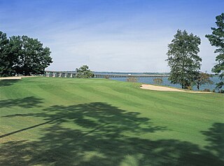
Santee is a town in Orangeburg County along the Santee River Valley in central South Carolina, United States. It has become a resort town of note located centrally north-south along the Atlantic Seaboard of South Carolina. The region has been rural, with a primarily agricultural economy typical of Orangeburg County, but is now known primarily for its several golf courses in proximity to Lake Marion, Santee State Park and other Lake Marion attractions. Interstate 95 connects its attractions easily with tourists traveling by automobile. I-95 crosses a narrow arm of the lake into the town lands, along a causeway. Lake Marion is a man-made hydroelectric reservoir, which at 110,000 acres is one of the fifty largest lakes in the country.

The Cooper River is a mainly tidal river in the U.S. state of South Carolina. The cities of Mt. Pleasant, Charleston, North Charleston, Goose Creek, Moncks Corner, and Hanahan are located along the river. Short and wide, the river is joined first by the blackwater East Branch and then farther downstream at the tidal Wando River. Almost immediately thereafter, the Cooper River widens into its estuary and unites with the Ashley River to form the Charleston Harbor.
The Knife River is a 27.4-mile-long (44.1 km) tributary of the Snake River in east-central Minnesota in the United States. It is one of three streams in Minnesota with this name. Its name is a translation from the Dakota Isaanti. Knife Lake and Santee Sioux are named after this river. In turn Isanti County is named after the Santee Sioux.

The Santee Sioux Reservation of the Santee Sioux was established in 1863 in present-day Nebraska. The tribal seat of government is located in Niobrara, Nebraska, with reservation lands in Knox County.

The Dakota are a Native American tribe and First Nations band government in North America. They compose two of the three main subcultures of the Sioux people, and are typically divided into the Eastern Dakota and the Western Dakota.

McWilliams is an unincorporated community in Wilcox County, Alabama, United States. The town is named for the general store established there by the McWilliams family, who migrated to South Alabama from the Orangeburg District of South Carolina. There are many McWilliamses of this root still living in Alabama. Another leading branch of the same family left Wilcox County and took up land patents at Blackwater in Kemper County, Mississippi.
Eastabuchie is an unincorporated community in southwestern Jones County, Mississippi. It is located along U.S. Route 11, just north of the Forrest County line. Although it is unincorporated, the community has a post office, with the ZIP code of 39436. Eastabuchie is part of the Laurel Micropolitan Statistical Area.

Lake Santee is an unincorporated town and census-designated place in Decatur and Franklin counties, Indiana, United States. As of the 2010 census, it had a population of 820.
Dogwood is an unincorporated community in Mississippi County, in the U.S. state of Missouri.
Fuget is an extinct town in Mississippi County, in the U.S. state of Missouri. The GNIS classifies it as a populated place.
Bogue Cheely is a stream in the U.S. state of Mississippi.
Hatchapaloo Creek is a stream in the U.S. state of Mississippi. It is a tributary to Oakohay Creek.
Okahola is an unincorporated community in Lamar County, in the U.S. state of Mississippi.
Quofaloma is an unincorporated community in Holmes County, in the U.S. state of Mississippi.
Tuscola is an unincorporated community in Leake County, in the U.S. state of Mississippi.
References
- ↑ U.S. Geological Survey Geographic Names Information System: Santee Branch
- ↑ Baca, Keith A. (2007). Native American Place Names in Mississippi. University Press of Mississippi. p. 90. ISBN 978-1-60473-483-6.
Coordinates: 31°33′42″N89°39′09″W / 31.5615569°N 89.6525720°W
| This article related to a river in Mississippi is a stub. You can help Wikipedia by expanding it. |