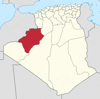
Béchar is a province (wilaya) in Algeria, named after its capital Béchar.
Igli is a town and commune in Béchar Province, western Algeria, located 152 km south of Bechar. It is coextensive with Igli District. Its population was 6,682 as of the 2008 census, up from 5,474 in 1998, and an annual population growth rate of 2.1%. The commune covers an area of 6,220 square kilometres (2,400 sq mi).

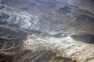
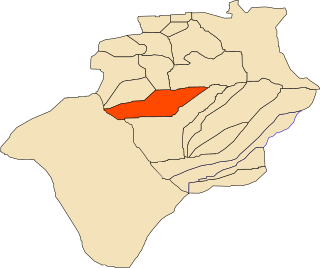
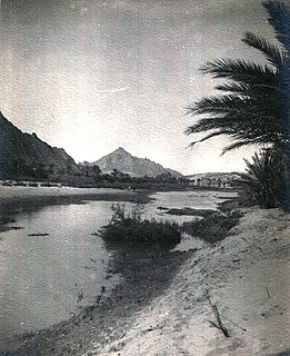
Béni Abbès is a district in Béchar Province, Algeria. It was named after its capital, Béni Abbès. According to the 2008 census, the total population of the district was 12,134 inhabitants. The population lives almost exclusively on the banks of the Oued Saoura; to the northeast is the uninhabited Grand Erg Occidental, while to the southwest is the rocky hamada and the mountainous Ougarta Range. The N6 is the main road through the district, running from northwest to southeast.

Béni Abbès, also known as the Pearl of the Saoura, and also as the White Oasis, is a town and commune located in western Algeria in Béchar Province, 241 kilometres (150 mi) far from the provincial capital Béchar, and 1,200 kilometres (750 mi) from Algiers.

Béni Ikhlef is a town and commune in Kerzaz District, Béchar Province, in western Algeria. According to the 2008 census its population is 2,459, up from 2,280 in 1998, with an annual growth rate of 0.8%. The commune covers an area of 2,617 square kilometres (1,010 sq mi).
El Ouata is a town and commune in Béchar Province, western Algeria. The commune is coextensive with El Ouata District, which is named after the town. According to the 2008 census its population is 7,343, up from 7,014 in 1998, with an annual population growth rate of 0.5%. The commune covers an area of 2,870 square kilometres (1,110 sq mi).

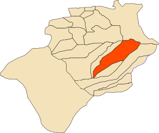
Kerzaz is a town and commune, and capital of Kerzaz District, in Béchar Province, western Algeria. According to the 2008 census its population is 5,028, up from 4,276 in 1998, and its annual growth rate is 1.7%. The commune covers an area of 10,520 square kilometres (4,060 sq mi).

Tamtert, also written Tamert or Tamatart is a town and commune in Béni Abbès District, Béchar Province, in western Algeria. According to the 2008 census its population is 1,248, down from 1,302 in 1998, with an annual growth rate of -0.4%. The commune covers an area of 3,130 square kilometres (1,210 sq mi).

Oued Guir is an intermittent river or wadi that flows through the Drâa-Tafilalet and Oriental regions in southeastern Morocco and Béchar Province in western Algeria.
Oued Zouzfana is an intermittent river, or wadi, that flows through the Oriental region in southeastern Morocco and Béchar Province in southwestern Algeria.

Djorf Torba Dam is a dam in Kenadsa District, Béchar Province, Algeria, crossing the Oued Guir about 50 kilometres (31 mi) west of the capital, Béchar. It is used for the purposes of irrigation and water supply. The area around the head of the dam features a number of notable ancient monuments. The dam has resulted in a significant reduction in the flow of Oued Guir and Oued Saoura in locations downstream of the dam.

Ougarta is an oasis and a village in the commune of Béni Abbès, in Béchar Province, Algeria. It is 50 kilometres (31 mi) southwest of the town of Béni Abbès and about 250 kilometres (160 mi) south of Béchar, the capital of the province. Ougarta has a population of about 250 inhabitants. The village has given its name to the Ougarta Range which surrounds the village. A local road connects the village to the N6 highway near Béni Abbès.
Mazzer is a village in the commune of Igli, Algeria, in Béchar Province, Algeria. The village lies on the Oued Saoura south of Igli and north of Béni Abbès.
Guerzim is a village in the commune of Béni Ikhlef, in Kerzaz District, Béchar Province, Algeria. The village lies on the Oued Saoura 10 kilometres (6.2 mi) north of Béni Ikhlef and 28 kilometres (17 mi) southeast of El Ouata.
Marhouma is a village in the commune of Tamtert, in El Ouata District, Béchar Province, Algeria. The village lies on the Oued Saoura 19 kilometres (12 mi) northwest of Tamtert and 18 kilometres (11 mi) southeast of Béni Abbès. It is notable for nearby rock engravings.
Béchir is a village in the commune of Tamtert, in El Ouata District, Béchar Province, Algeria. The village lies on the Oued Saoura 7 kilometres (4.3 mi) northwest of Tamtert and 29 kilometres (18 mi) southeast of Béni Abbès.
Zaouia el Kbira is a village in the commune of Kerzaz, in Béchar Province, Algeria. It lies on the Oued Saoura between Béni Ikhlef and Kerzaz. The village is on the N6 national highway, 8 kilometres (5.0 mi) northwest of Kerzaz and 15 kilometres (9.3 mi) southeast of Béni Ikhlef.
Idigh is a village in the commune of Tamtert, in Béni Abbès District, Béchar Province, Algeria. The village is located on a local road on the north-eastern bank of the Oued Saoura, about halfway between Tamtert and El Ouata.
The 2016–17 Algerian Cup is the 53rd edition of the Algerian Cup. The winner will qualify to the 2018 CAF Confederation Cup.