Shimla is the capital and the largest city of the northern Indian state of Himachal Pradesh. In 1864, Shimla was declared the summer capital of British India. After independence, the city became the capital of East Punjab and was later made the capital city of Himachal Pradesh. It is the principal commercial, cultural and educational centre of the state.

Solan is a city in the Indian state of Himachal Pradesh and the district headquarters of Solan district. It is located 45.5 kilometres (28 mi) south of the state capital, Shimla. Solan has an average elevation of 1,550 metres (5,090 ft). The city is situated between Chandigarh and Shimla on the Kalka-Shimla National Highway-5. The narrow-gauge Kalka-Shimla railway passes through Solan. Located on the Punjab-Himachal Border, Solan is nestled in the Shivalik hills of the Himalayas.

Manali is a town, near Kullu town in Kullu district in the Indian state of Himachal Pradesh. It is situated in the northern end of the Kullu Valley, formed by the Beas River. The town is located in the Kullu district, approximately 270 kilometres (170 mi) north of the state capital of Shimla and 544 kilometres (338 mi) northeast of the national capital of New Delhi. With a population of 8,096 people recorded in the 2011 Indian census Manali is the beginning of an ancient trade route through Lahaul (H.P.) and Ladakh, over the Karakoram Pass and onto Yarkand and Hotan in the Tarim Basin of China. Manali is a popular tourist destination in India and serves as the gateway to the Lahaul and Spiti district as well as the city of Leh in Ladakh.

Kinnaur district is one of the twelve administrative districts of the state of Himachal Pradesh in northern India. The district is divided into three administrative areas and has six tehsils. The administrative headquarters of the district is at Reckong Peo. The revered Kinnaur Kailash mountain, one of the Panch Kailash sites, is situated in Kinnaur. As of 2011, it is the second least populous district of Himachal Pradesh, after Lahaul and Spiti.

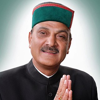
Virbhadra Singh was an Indian politician who served 6 terms and 21 years as the 4th Chief Minister of Himachal Pradesh. A leader of the Indian National Congress party, he was elected 9 times as a Member of Legislative Assembly to the Himachal Pradesh Vidhan Sabha and 5 times as Member of Parliament to the Lok Sabha. Virbhadra Singh was popularly known by the honorific Raja Sahib. Singh holds the distinction of being the longest serving Chief Minister of Himachal Pradesh, holding the office from 1983 to 1990, from 1993 to 1998, from 2003 to 2007 and finally from 2012 to 2017, when he was succeeded by the BJP's Jai Ram Thakur. He was elected to the Lok Sabha in 1962, 1967, 1971, 1980 and 2009. Singh served as a Union Minister in the governments of Indira Gandhi and Manmohan Singh. At the time of his demise, he was serving as an MLA from Arki constituency.

Bushahr, also spelt as 'Bashahr' and 'Bussahir' or 'Bushair' was a Rajput princely state in India during the British Raj. It was located in the hilly western Himalaya promontory bordering Tibet.

Shimla district is one of the twelve districts of the state of Himachal Pradesh in northern India. Its headquarters is the state capital of Shimla. Neighbouring districts are Mandi and Kullu in the north, Kinnaur in the east, Uttarakhand in the southeast, Solan to the southwest and Sirmaur in the south. The elevation of the district ranges from 987 metres (3,238 ft) to 4,500 metres (14,764 ft).

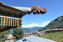
Chail is a hill station in Solan district of Himachal Pradesh, India. It is 45 kilometres (28 mi) from Solan city and 44 kilometres (27 mi) from Shimla. It is known for its salubrious beauty and virgin forests. The Chail Palace is well known for its architecture: the palace was built as a summer retreat by the Maharaja of Patiala during the British Raj, on the land allotted to him by the British for the former's assistance in the Anglo-Nepalese War. The cricket ground and a polo ground which is there at an altitude of 2,444 m are owned by the erstwhile royal family of Patiala. It is the world's highest cricket ground.

Rampur Bushahr is a town and a municipal council in Shimla district in the Indian state of Himachal Pradesh. It is about 130 km from Shimla and is well connected with NH 5 which passes through Theog, Narkanda and Kumarsain.
Waknaghat is a small town in Solan district in the Indian state of Himachal Pradesh which falls on the way to Shimla, India from Kalka, India. It is located on National Highway 22. Waknaghat is around 22 km (14 mi) from Shimla and 25 km (16 mi) from Solan. Other nearby villages and towns are Wakna, Domehar, Aanji-Sunara, Sabathu, Mamlig, Shoghi and Kandaghat, Dhyari PG FOR BOYS BAHRA UNIVERSITY. Nearby railway stations include Kaithli-Ghat, 3 km (1.9 mi) from Waknaghat, and Kandaghat, 12 km (7.5 mi) from Waknaghat.
The Daranghati Sanctuary is located in Rampur Bushahr, Shimla, Himachal Pradesh, India. It has undisturbed forest areas. Monal, Tragopan, Koklas and Kalij are the pheasants found here. Some of the common animals found here are Musk deer, Goral and Thar. Forest staff posted at Dofda and Sarahan is there for advice and guidance.
Himachal Pradesh, although railways and airways serve very limited transport needs, the road network of the state serves the transport needs of the people. Although, the geography of Himachal presents considerable challenge to the development of transport infrastructure, it has the highest road density among all the Hill States of India. Himachal also has 3 airports, 2 narrow gauge rail tracks and couple of other under-construction broad gauge railway tracks, but roads remain the main mode of transport.

Baragaon is a village in Kumarsain subdivision of Shimla district in the Indian state of Himachal Pradesh.

National Highway 5 (NH5) is a primary national highway in India, running from West to East, connecting Firozpur in Punjab to the Sino-Indian border at Shipki La. The highway passes through Moga, Jagraon, Ludhiana, Mohali, Chandigarh, Panchkula, Kalka, Solan, Shimla, Theog, Narkanda, Kumarsain, Rampur Bushahr and continues along the Sutlej River till its terminus near the Tibet border.

Hatu Peak is located in the Shimla district of Himachal Pradesh in India. It is one of the highest peaks in the region, standing at an elevation of 3400 meters (11,152ft) above sea level. The peak is surrounded by a dense forest of conifers, oaks, and maples.

Kumarsain, also known as Kumharsain, is a town in Shimla District in the Indian state of Himachal Pradesh. Formerly under the British Raj, it was the capital of princely state of Kumharsain, which was one of the several states of the Punjab States Agency. It is about 80 km from Shimla and famous for apple and cherry orchards.
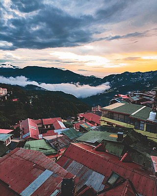
Tourism in Himachal Pradesh relates to tourism in the Indian state of Himachal Pradesh. This is popularly renowned for its Himalayan landscapes and popular hill-stations. Many outdoor activities such as rock climbing, mountain biking, paragliding, ice-skating, trekking, rafting, and heli-skiing are popular tourist attractions in Himachal Pradesh.

Nankhari is a Tehsil (town) and a block in Shimla district in the Indian state of Himachal Pradesh. It is about 92.5 km from Shimla and 33 km from Narkanda and NH 5. It consists of 17 Gram panchayat and 102 villages.
Nand Lal is an Indian politician, who currently serves as MLA from Rampur constituency. He is associated with Indian National Congress. He is son of Pyare Lal. He was born at Deothi, Distt. Shimla. He is a Post Graduate in Political Science from Himachal Pradesh University, Shimla. He is married to Smt. Satya.

Vikramaditya Singh is an Indian politician, who currently serves as Member of Legislative Assembly from Shimla Rural constituency. He is the son of the former chief minister of Himachal Pradesh Late Virbhadra Singh. His mother is Pratibha Singh, who was a Member of Parliament from Mandi, Lok Sabha Constituency.