
Slovakia is a landlocked Central European country with mountainous regions in the north and flat terrain in the south. Slovakia was during much of the Holocene much more forested than today. Decline of the forest occurred in as consequence of the Valachian colonization and the development of mining in the territory.

A ski resort is a resort developed for skiing, snowboarding, and other winter sports. In Europe, most ski resorts are towns or villages in or adjacent to a ski area – a mountainous area with pistes and a ski lift system. In North America, it is more common for ski areas to exist well away from towns, so ski resorts usually are destination resorts, often purpose-built and self-contained, where skiing is the main activity.

Harishchandragad is a hill fort in the Ahmednagar district of India. Its history is linked with that of Malshej Ghat, kothale village and it has played a major role in guarding and controlling the surrounding region.
Nelaug is a lake in the municipalities of Froland and Åmli in Agder county, Norway. The 10 kilometres (6.2 mi) lake is formed by a dam which regulates a hydroelectric power plant on the Nidelva river. The village of Nelaug is located near the dam in Froland municipality. The lake is located about 11 kilometres (6.8 mi) south of the village of Åmli, about 15 kilometres (9.3 mi) southeast of the village of Dølemo, and about 20 kilometres (12 mi) north of Blakstad.
Mastung, the capital of Mastung District, is a town in the Balochistan province of Pakistan. It is located at 29°48'0N 66°50'60E and has an altitude of 1701 metres. The town is also the administrative centre of Mastung Tehsil, an administrative subdivision of the district – the town itself is administratively subdivided into two Union Councils.
Aigali is a village in the southern state of Karnataka, India. It is located in the Athani taluk of Belgaum district in Karnataka.
Benadi is a village in the North-Western region of Karnataka state near Maharashtra Border in India. It is located in the Chikodi taluka of Belgaum district in Karnataka. Before it was a part of Bombay State and Princely state of Kolhapur. It is a part of Twin Village Aadi-Benadi. People who has origin from this village are known as Benadikar.
Bhiradi is a village in the southern state of Karnataka, India. It is located in the Raybag taluk of Belgaum district in Karnataka.
Hirekudi is a village in the southern state of Karnataka, India. It is located in the Chikodi taluk of Belgaum district in Karnataka.
Madabhavi is a large village located in Athani taaluk of Belagavi district, Karnataka state of India. The village is famous for the production of leather chappals, which have main market in Kolhapur. The village name comes from "Madya" meaning central and "Bhavi" meaning an open well. The open well is situated near panchayat of the village. Kalbhairava and Madhukeshwar are two ancient temples in this village.
Mullur is a village near Sarjapur road in Karnataka, India. It is in Bengaluru East Taluk, Bengaluru District in Karnataka. An adjacent village is Gunjur via Kachamaranahalli. The distance from Vidhana Soudha is 22 km.out of the village there is one school called Sri Sri Ravishankar vidhya mandir and there is a railway station 3.5 km from the village.

The following is a list of reportedly haunted locations in the United Kingdom.
Badachi is a village in Belgaum district in the southern state of Karnataka, India. It is located in Athani Taluka of Belgaum District, near Bijapur -Athani Highway. Maashahibi Darga is situated in the village managed by native Mulla(s) .Allabax S MULLA, Peeralal s mulla, Badashahlal d mulla and every year Maashahibi and Shakarbashah Uras is happen in April or may month,
Halolli is a village in Belgaum district in the southern state of Karnataka, India.

National Highway 7 is a highway connecting Fazilka (Punjab) to Mana (Uttarakhand) in India. It passes through the Indian states of Punjab, Haryana, Himachal Pradesh, and Uttarakhand.
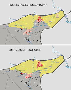
The Eastern al-Hasakah offensive was launched in the Al-Hasakah Governorate during the Syrian Civil War, by the Kurdish-majority People's Protection Units, Assyrian Christian militias, and allied Arab forces against the jihadist Islamic State of Iraq and the Levant, with the intent of retaking the areas of the Jazira Canton that had been captured by ISIL. Subsequently, the Syrian Armed Forces also launched an assault against the jihadists, without coordinating with the YPG.

The Raqqa campaign was a military operation launched in November 2016 during the Rojava–Islamist conflict by the Syrian Democratic Forces (SDF) against the Islamic State of Iraq and the Levant (ISIL) in the Raqqa Governorate, with the goal of isolating and eventually capturing the Islamic State's capital city, Raqqa. The SDF's subsidiary goals included capturing the Tabqa Dam, the nearby city of al-Thawrah, and the Baath Dam further downstream. The campaign ended successfully in October 2017, with the capture of Raqqa.
The 2017 Western Nineveh offensive, code-named Operation Muhammad, Prophet of God, was launched by the Iraqi Popular Mobilization Forces (PMF) against the Islamic State of Iraq and the Levant (ISIL) in the western Nineveh province of northern Iraq in late April 2017.
The Islamic State insurgency in Iraq is an ongoing low-intensity insurgency that began in December 2017 after the Islamic State (ISIS) lost territorial control in the War in Iraq of 2013 to 2017. ISIS and allied White Flags fought the Iraqi military and allied paramilitary forces.

Checleset Bay is a bay on the northwest coast of Vancouver Island, British Columbia, Canada. It is located southeast of Brooks Peninsula and northwest of Kyuquot Sound. Much of the land around the bay is part of Brooks Peninsula Provincial Park. Checleset Bay has three large inlets, Nasparti Inlet, Ououkinsh Inlet, and Malksope Inlet.

