
Benton County is a county in the U.S. state of Minnesota. As of the 2010 United States Census, the population was 38,451. Its county seat is Foley. Established in 1849 and organized in 1850, the county is one of the oldest in Minnesota. It was named for Thomas Hart Benton, a United States Senator from Missouri.

The Hennepin Avenue Bridge is the structure that carries Hennepin County State Aid Highway 52, Hennepin Avenue, across the Mississippi River in Minneapolis, Minnesota, at Nicollet Island. Officially, it is the Father Louis Hennepin Bridge, in honor of the 17th-century explorer Louis Hennepin, who was the first European to see the Saint Anthony Falls, a short distance downriver. Two of the three previous structures have been suspension bridges, while a third—which existed nearly a century—was composed of steel arch spans. The original crossing, which opened as a toll bridge on January 23, 1855, is believed to have been the first permanent span across the Mississippi at any point. Other bridges were completed in 1876, 1891, and most recently 1990. Today, the bridge's main span is 190 metres (620 ft) in length, making it rather small by modern standards.

The 10th Avenue Bridge crosses the Mississippi River near downtown Minneapolis, Minnesota and also in proximity to the University of Minnesota. The bridge was formerly called the Cedar Avenue Bridge from days prior to the construction of the I-35W bridge when it connected to Cedar Ave. The bridge connects 10th Avenue Southeast, on the east side of the Mississippi River to 19th Avenue South, on the west side. The bridge is considered the crowning achievement of Minneapolis city engineer Kristoffer Olsen Oustad, who was one of four prominent Norwegian-American men who designed major structures in the region. It was added to the National Register of Historic Places in 1989, and also marks the downstream boundary of the Saint Anthony Falls Historic District. During the days immediately following the I-35W bridge collapse, the 10th Avenue Bridge was closed to traffic, then later reopened; it was one of the most used locations from which to view the wreckage and the recovery efforts.
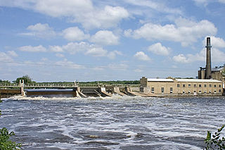
The Sartell Dam is a dam across the Mississippi River in Sartell, Minnesota in the United States. The dam was used to generate hydroelectric power for the adjoining Sartell Paper Mill before it burned down in 2012. The dam is referred to as the Champion Dam in official documentation.

The Robert Street Bridge is a reinforced concrete multiple-arch bridge that spans the Mississippi River in downtown St. Paul, Minnesota. The bridge is notable for its complex design that was required to accommodate river traffic, the St. Paul Union Pacific Vertical-lift Rail Bridge crossing underneath it at an angle, and roadways on the downtown side of St. Paul. The bridge is also notable for a monumental reinforced concrete rainbow arch. The rainbow arch not only provides 62 feet of headroom above the river, but also provides a strong aesthetic focus. It was built in 1924-1926 by Fegles Construction Company, Ltd. and designed by Toltz, King & Day. The bridge was added to the National Register of Historic Places in 1989. The bridge as well as Robert Street itself are named after Captain Louis Roberts, a notable French Canadian river boat captain, businessman and early settler of Saint Paul, MN.

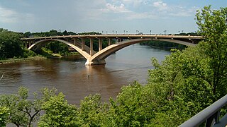
The Intercity Bridge, more commonly known as the Ford Parkway Bridge, is a reinforced concrete arch bridge that spans the Mississippi River between Minneapolis, Minnesota and St. Paul, Minnesota, United States. It connects 46th Street in Minneapolis with Ford Parkway in Saint Paul. The bridge is historically significant as one of the largest reinforced concrete bridges ever built in Minnesota. It was built in 1925-1927 by James O. Heyworth, Inc. and was designed by Martin Sigvart Grytbak. The Intercity Bridge was listed on the National Register of Historic Places in 1989. It is notable as one of the monumental concrete rib-arch bridges spanning the high river bluffs along the Mississippi River, along with the Franklin Avenue Bridge, the Third Avenue Bridge, the 10th Avenue Bridge, and the Robert Street Bridge.
The Lake Street-Marshall Avenue Bridge is a reinforced concrete arch bridge that spans the Mississippi River between Minneapolis, Minnesota and St. Paul, Minnesota. It is oriented East-West and connects Lake Street in Minneapolis to Marshall Avenue in St. Paul. St. Paul residents often refer to it as the Marshall Avenue Bridge. The bridge was designed by Howard, Needles, Tammen, and Bergendoff.
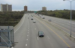
The Dartmouth Bridge is a steel girder bridge that spans the Mississippi River in Minneapolis, Minnesota, between the Cedar-Riverside area and the University of Minnesota campus area. It carries I-94/US 12/US 52. It was built in 1964 and was designed by Parsons Brinckerhoff, Quade and Douglas. It is named for its proximity to Dartmouth Avenue SE, just north of the bridge.

Northern Pacific Bridge #9 is a deck truss bridge that spans the Mississippi River in Minneapolis, Minnesota, between the Seven Corners area and the University of Minnesota campus. It was built in 1924 and was designed by Frederick W. Cappelen. Railroad use of the bridge ended in 1981, and in 1999 the bridge was opened to bicycles and pedestrians. It replaced the former Northern Pacific "A Line" bridge.

La Crosse Rail Bridge is a swing bridge that spans the Mississippi River between La Crescent, Minnesota and La Crosse, Wisconsin.

Hastings Rail Bridge is a vertical-lift bridge that spans the Mississippi River in Hastings, Minnesota. It is one of only four lift spans on the Mississippi River, the others being at Hannibal, Missouri, Burlington, Iowa and in downtown St. Paul, Minnesota. It was built in 1981 by Milwaukee Road and was designed by Howard, Needles, Tammen & Bergendoff.

The Anoka–Champlin Mississippi River Bridge, also known as the Ferry Street Bridge, is a 10-span open spandrel concrete deck arch bridge that spans the Mississippi River between Anoka and Champlin, Minnesota, United States. It was built in 1929 by the Minneapolis Bridge Company, replacing an 1884 bridge at the same site.

Richard P. Braun Bridge is a pair of 10-span concrete girder bridges spanning the Mississippi River between Brooklyn Park, Minnesota and Coon Rapids, Minnesota. The eastbound span was built in 1985 to connect Minnesota State Highway 252 with Minnesota State Highway 610 in Coon Rapids. The westbound span was built in 1999 as part of the continued construction of Highway 610 through Brooklyn Park. Richard P. Braun is a former Mn/DOT Commissioner from 1979-1986.
Canadian Pacific Camden Place Rail Bridge is a truss bridge that spans the Mississippi River in Minneapolis, Minnesota. This bridge is the official end of the navigable channel for river traffic. It was built in 1905 by the Minneapolis, St. Paul and Sault Ste. Marie Railway. In 1977, the bridge was modified to allow higher clearance under the center span. This was done by replacing the deck truss span with a shallower girder span. It is the main line crossing of the Mississippi River for the Canadian Pacific Railway transcontinental line.

The Bridge of Hope is a concrete girder bridge that spans the Mississippi River between Sartell, Minnesota and Sauk Rapids, Minnesota. The bridge was completed eight months early, aided by favorable weather and trouble-free construction. It was built in 1995 and was designed by Minnesota Department of Transportation and the Jim Hill Group.
Minnesota State Highway 15 is a highway in south-central and central Minnesota, which runs from Iowa Highway 15 at the Iowa state line and continues north to its northern terminus at its interchange with U.S. Highway 10 outside of Sartell and Sauk Rapids, north of St. Cloud.

The Old Sartell Bridge is a bridge that spans the Mississippi River in the city of Sartell in the U.S. state of Minnesota. Though still standing, it is closed to traffic and was replaced by the Sartell Bridge constructed about 850 feet downstream. The bridge is around 1000 feet downstream of the Sartell Dam. The bridge was built during a six-month period in 1914, but over the years the bridge became congested and less able to carry heavy traffic. As early as 1957, heavy trucks were found to be too much for the span. When the new bridge was built in 1984, the old bridge was used as a pedestrian footbridge, but it became impractical for this use since there is now a factory at the east end. The bridge now carries only utility lines.

Lexington Bridge is a plate girder bridge that spans the Mississippi River between Saint Paul and Lilydale, Minnesota, United States. It was built in 2004 by the Minnesota Department of Transportation.


