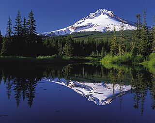
Mount Hood is an active stratovolcano in the Cascade Volcanic Arc. It was formed by a subduction zone on the Pacific coast and rests in the Pacific Northwest region of the United States. It is located about 50 mi (80 km) east-southeast of Portland, on the border between Clackamas and Hood River counties. In addition to being Oregon's highest mountain, it is one of the loftiest mountains in the nation based on its prominence, and it offers the only year-round lift-served skiing in North America.

Mount Adams, known by some Native American tribes as Pahto or Klickitat, is a potentially active stratovolcano in the Cascade Range. Although Adams has not erupted in more than 1,000 years, it is not considered extinct. It is the second-highest mountain in Washington, after Mount Rainier.

Pico de Orizaba, also known as Citlaltépetl, is an active volcano, the highest mountain in Mexico and third highest in North America, after Denali of United States and Mount Logan of Canada. Pico de Orizaba is also the highest volcano in North America. It rises 5,636 metres (18,491 ft) above sea level in the eastern end of the Trans-Mexican Volcanic Belt, on the border between the states of Veracruz and Puebla. The volcano is currently dormant but not extinct, with the last eruption taking place during the 19th century. It is the second most prominent volcanic peak in the world after Mount Kilimanjaro. Pico de Orizaba is ranked 16th by topographic isolation.

Mount Timpanogos, often referred to as Timp, is the second-highest mountain in Utah's Wasatch Range. Timpanogos rises to an elevation of 11,752 ft (3,582 m) above sea level in the Uinta-Wasatch-Cache National Forest. With 5,270 ft (1,610 m) of topographic prominence, Timpanogos is the 47th-most prominent mountain in the contiguous United States.

Nabesna Glacier is a glacier in the U.S. state of Alaska. Fed by deep snowfall in the Wrangell Mountains, the 53 mile (85 km) long Nabesna is the longest valley glacier in North America and the world's longest interior valley glacier.

Goode Mountain is one of the major peaks of the North Cascades in the U.S. state of Washington. Named for topographer Richard Urquhart Goode of the United States Geological Survey, it is the highest peak located in North Cascades National Park, between the Skagit River and Lake Chelan. It is the fourth-highest non-volcanic peak in Washington, and the twelfth-highest summit overall.
The Williwakas Glacier is a glacier located on the south flank of Mount Rainier in Washington. The glacier lies below the Paradise Glacier. Due to its relatively low elevation—6,600 feet (2,000 m)–6,900 feet (2,100 m)—the glacier is small and surrounded by small snow fields above the regional tree line. A stubby 7,163 ft (2,183 m) peak is located to the east of the glacier.
The Van Trump Glacier is a scattering of glaciers and snowfields located on the southern flank of Mount Rainier in Washington. Named after P. B. Van Trump, who was part of an early ascent of Mount Rainier, the glacier covers 0.2 square miles (0.5 km2) and contains 500 million ft3 of ice. The glacier is located between the Wilson Glacier to the east and the Kautz Glacier to the west. The elevation of the scattering ranges from 7,000 feet (2,100 m) at the lower end to 9,800 ft (3,000 m) on the upper reaches of the glacier. Meltwater from the glacier drains into the Nisqually River.
The Pyramid Glacier is actually a scattering of glaciers and snowfields located on the south-southwestern flank of Mount Rainier in Washington. It covers 0.2 square miles (0.5 km2) and contains 400 million ft3 of ice. The glaciers lie at an elevation ranging from about 7,000 feet (2,100 m) to 9,000 ft (2,700 m). The Success Divide separates this glacier from the South Tahoma Glacier to the west. Both the Success Glacier and lower end of the Kautz Glacier border this glacier on the eastern side. Meltwater from the glacier drains into the Nisqually River.
Edmunds Glacier is located on Mount Rainier in the U.S. state of Washington. Named in 1883 for Vermont senator George F. Edmunds, the glacier lies on the western flank of the volcano below the steep, rocky Mowich Face and Sunset Face. Starting from an elevation of about 9,900 ft (3,000 m), the glacier flows northwest down to 7,000 ft (2,100 m) and ends northeast of the Jeanette Heights region of Mount Rainier. Meltwater from the Edmunds Glacier feeds the Mowich River which eventually merges with the Puyallup River.

The Russell Glacier is a medium-sized glacier on the north flank of Mount Rainier, Washington. Named for the geologist Israel Russell, it covers 1.3 square miles (3.4 km2) and contains 3.1 billion ft3 of ice. Starting from its highest point at 9,400 feet (2,900 m), the Russell Glacier flows northeast towards the Carbon Glacier and contributes ice to the larger glacier before becoming distinct below 7,000 feet (2,100 m). With most of the ice located from 8,000 feet (2,400 m) to 9,000 feet (2,700 m), the glacier only descends to 6,800 feet (2,100 m), unlike the much lower extent of the Carbon Glacier. Echo Rock and 8,364 ft (2,549 m) Observation Rock, two minor sub-peaks of Rainier, lie northwest of this glacier. Meltwater from the glacier eventually reaches the Carbon River.

Paradise Glacier is a glacier on the southeast flank of Mount Rainier in Washington. It covers 0.4 square miles (1.0 km2) and contains 0.8 billion ft3 with Stevens Glacier included. The glacier is bounded to the west by the Muir Snowfield, Anvil Rock and McClure Rock. There is a single extant main lobe of the glacier, ranging from 9,000 feet (2,700 m) to 7,200 feet (2,200 m), that is connected to the larger Cowlitz Glacier. To the south, there was a smaller portion which was near the Cowlitz Rocks and the tiny Williwakas Glacier, ranging from 6,900 feet (2,100 m) to 6,400 ft (2,000 m) in elevation and containing the Paradise Ice Caves until the 1990s. This smaller lobe melted between 2004 and 2006. Meltwater from the glacier drains into the Cowlitz River.

Adams Glacier is situated on the northwest flank of Mount Adams, a 12,281-foot (3,743 m) stratovolcano in the U.S. state of Washington. Much of it becomes the source of Adams Creek, a tributary of the Cispus River. It is the largest glacier on Mount Adams. It flows down from the summit ice cap at over 12,000 feet (3,700 m) for over 2.5 miles (4.0 km) to a terminus near 7,000 feet (2,100 m).

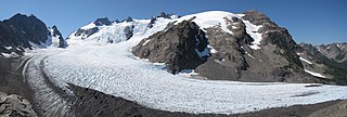
Blue Glacier is a large glacier located to the north of Mount Olympus in the Olympic Mountains of Washington. The glacier covers an area of 1.7 sq mi (4.4 km2) and contains 580,000,000 cu ft (16,000,000 m3) of ice and snow in spite of its low terminus elevation. The glacier length has decreased from about 3.4 mi (5.5 km) in 1800 to 2.7 mi (4.3 km) in the year 2000. Just in the period from 1995 and 2006, Blue Glacier retreated 325 ft (99 m). Blue Glacier is also thinning as it retreats and between 1987 and 2009 the glacier lost 178 ft (54 m) of its depth near its terminus and between 32 and 48 ft in the uppermost sections of the glacier known as the accumulation zone.
Carrie Glacier is located on Mount Carrie and Mount Fairchild in the Olympic Mountains of Olympic National Park. Starting at an elevation of about 6,800 feet (2,100 m), the glacier descends northward, but the ice soon reaches a cliff. Part of the Carrie Glacier plunges over the steep rockwall, contributing ice to an adjacent glacier, while the other section flows north-northeast, avoiding the precipitous drop. This segment of ice is confined by an arête to the west and Mount Fairchild to the east in a chute. The glacier reaches as low as 5,000 ft (1,500 m) before terminating. There are several other patches of snow and glaciers located nearby, such as the Fairchild Glacier.

The Suiattle River is a river in the northern Cascade Mountains of western Washington. A tributary of the Sauk River and by extension the Skagit River, the river's 60 miles (97 km) course lies mainly within the Mount Baker-Snoqualmie National Forest. The river's watershed is heavily forested and undeveloped, with human use mainly limited to outdoor recreation. The Suiattle holds great cultural importance among the eponymous Sauk-Suiattle nation. It is an important spawning site for various species of salmon and trout.

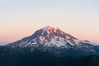
Mount Rainier, also known as Tahoma, is a large active stratovolcano in the Cascade Range of the Pacific Northwest in the United States. The mountain is located in Mount Rainier National Park about 59 miles (95 km) south-southeast of Seattle. With a summit elevation of 14,411 ft (4,392 m), it is the highest mountain in the U.S. state of Washington, the most topographically prominent mountain in the contiguous United States, and the tallest in the Cascade Volcanic Arc.

North Swiftcurrent Glacier is a glacier in Glacier National Park in the U.S. state of Montana. It is situated immediately to the east of the Continental Divide and north of Swiftcurrent Mountain at an elevation between 8,000 ft (2,400 m) and 7,000 ft (2,100 m) above sea level. North Swiftcurrent Glacier consists of several remnant glaciers and additional ice patches, none of which exceed 19 acres (0.077 km2) in surface area and do not meet the threshold of 25 acres (0.10 km2) often cited as being the minimum size to qualify as an active glacier. The glacier lost over 32 percent of its area between 1966 and 2005.
Whitecrow Glacier is in Glacier National Park, U.S. state of Montana. The glacier is situated immediately east of Mount Cleveland at an average elevation of 7,000 feet (2,100 m) above sea level. Whitecrow Glacier is in a cirque and consists of numerous ice patches, covering a combined surface area of 48 acres (0.19 km2). Between 1966 and 2005, Whitecrow Glacier lost over 47 percent of its surface area.

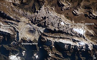
The East Northwall Firn was a glacier on Mount Carstensz in the Sudirman Range on the island of New Guinea in Central Papua province, Indonesia. Situated at an elevation of approximately 4,750 metres (15,580 ft) 2.5 kilometres (1.6 mi) NNW of Puncak Jaya, the highest summit in Oceania. It broke up in three patches in or before 2017.


