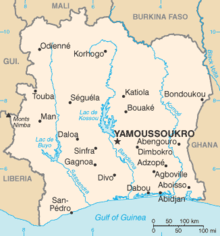
Ivory Coast is a sub-Saharan nation in southern West Africa located at 8° N, 5° W. The country is approximately square in shape.

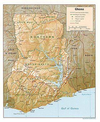
Ghana is a West African country in Africa, along the Gulf of Guinea.

Guinea is a country on the coast of West Africa and is bordered by Guinea-Bissau, Senegal, Mali, Ivory Coast, Liberia, and Sierra Leone.

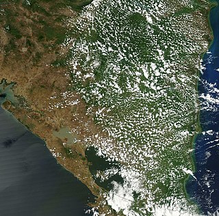
Nicaragua is a country in Central America, bordering both the Caribbean Sea and the North Pacific Ocean, between Costa Rica and Honduras. Nicaragua is the largest country in Central America in square kilometers.
The Global 200 is the list of ecoregions identified by the World Wide Fund for Nature (WWF), the global conservation organization, as priorities for conservation. According to WWF, an ecoregion is defined as a "relatively large unit of land or water containing a characteristic set of natural communities that share a large majority of their species dynamics, and environmental conditions". For example, based on their levels of endemism, Madagascar gets multiple listings, ancient Lake Baikal gets one, and the North American Great Lakes get none.

The Eastern Guinean forests are a tropical moist broadleaf forest ecoregion of West Africa.

The Nzérékoré Region is a region in the southern part of Guinea. Its capital and largest city is Nzérékoré. It is one of the eight regions of Guinea. It is bordered by the countries of Sierra Leone, Liberia, and Ivory Coast, and the Guinean regions of Kankan and Faranah.

Mount Nimba Strict Nature Reserve is a protected area and UNESCO World Heritage Site located in both Guinea and Côte d'Ivoire, extending over a total of area of 175.4 km2, with 125.4 km2 in Guinea, and 50 km2 in Côte d'Ivoire. The reserve covers significant portions of the Nimba Range, a geographically unique area with unusually rich flora and fauna, including exceptional numbers of single-site endemic species, such as Nimbaphrynoides, the Nimba otter shrew, and multiple species of horseshoe bats. Its highest peak is Mount Richard-Molard at 1,752 m (5,750 ft), which is the highest peak of both countries.

The Western Guinean lowland forests ecoregion is a tropical moist broadleaf forest ecoregion of West Africa. It is centered on Liberia, with portions in surrounding countries. It is the westernmost tropical rainforest in Africa, and has high levels of species endemism, with over 200 species of endemic plants.

The Upper Guinean forests is a tropical seasonal forest region of West Africa. The Upper Guinean forests extend from Guinea and Sierra Leone in the west through Liberia, Côte d'Ivoire and Ghana to Togo in the east, and a few hundred kilometers inland from the Atlantic coast. A few enclaves of montane forest lie further inland in the mountains of central Guinea and central Togo and Benin.

The wildlife of Ivory Coast consists of the flora and fauna of this nation in West Africa. The country has a long Atlantic coastline on the Gulf of Guinea and a range of habitat types. Once covered in tropical rainforest, much of this habitat has been cleared, the remaining terrain being gallery forests and savanna with scattered groups of trees, resulting in a decrease in biodiversity. As of 2016, 252 species of mammal had been recorded in Ivory Coast, 666 species of bird, 153 species of reptile, 80 species of amphibian, 671 species of fish and 3660 species of vascular plant.

The Atlantic Equatorial coastal forests, also known as the Congolian coastal forests, are a tropical moist broadleaf forest ecoregion of Central Africa, covering hills, plains, and mountains of the Atlantic coast of Cameroon, Equatorial Guinea, Gabon, Republic of the Congo, Angola, and Democratic Republic of the Congo.

The Guinea Highlands is a densely forested mountainous plateau extending from central Guinea through northern Sierra Leone and Liberia to western Ivory Coast. The highlands include a number of mountains, ranges and plateaus, including the Fouta Djallon highlands in central Guinea, the Loma Mountains in Sierra Leone, the Simandou and Kourandou massifs in southeastern Guinea, the Nimba Range at the border of Guinea, Liberia, and Ivory Coast, and the Monts du Toura in western Ivory Coast.

New Guinea is the world's second-largest island, with an area of 785,753 km2 (303,381 sq mi). Located in Melanesia in the southwestern Pacific Ocean, the island is separated from Australia by the 150-kilometre wide Torres Strait, though both landmasses lie on the same continental shelf, and were united during episodes of low sea level in the Pleistocene glaciations as the combined landmass of Sahul. Numerous smaller islands are located to the west and east. The island's name was given by Spanish explorer Yñigo Ortiz de Retez during his maritime expedition of 1545 due to the resemblance of the indigenous peoples of the island to those in the African region of Guinea.

The interior Alaska–Yukon lowland taiga is an ecoregion in the taiga and boreal forests biome, of far northern North America.

Soubré Department is a department of Nawa Region in Bas-Sassandra District, Ivory Coast. In 2021, its population was 587,441 and its seat is the settlement of Soubré. The sub-prefectures of the department are Grand-Zattry, Liliyo, Okrouyo, and Soubré.

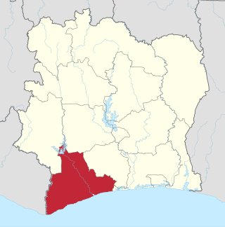
Bas-Sassandra District is one of fourteen administrative districts of Ivory Coast. The district is located in the southwest part of the country. The capital of the district is San-Pédro.

The Nimba Range forms part of the southern extent of the Guinea Highlands, adjacent to the Toura Mountains. The highest peak is Mount Nimba on the border of Liberia, Ivory Coast and Guinea, at 1,752 m (5,748 ft), and at the intersection of the Nimba and Toura Mountains. "Mount Nimba" may refer either to Mount Richard-Molard or to the entire range. Other peaks include Grand Rochers at 1,694 m (5,558 ft), Mont Sempéré at 1,682 m (5,518 ft), Mont Piérré Richaud at 1,670 m (5,480 ft), Mont Tô at 1,675 m (5,495 ft), and Mont LeClerc 1,577 m (5,174 ft), all of them are located in Guinea. Mount Nimba Strict Nature Reserve of Guinea and Ivory Coast covers significant portions of the Nimba Range.

The Southern New Guinea freshwater swamp forests is a tropical moist forest ecoregion in southern New Guinea. The ecoregion includes the extensive swamp forests of southern and western New Guinea.


