This article relies largely or entirely on a single source .(January 2026) |
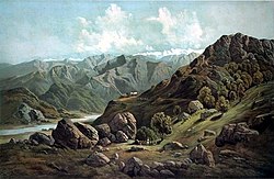
Satluj Valley [1] (alternative spelling Sutlej) is a valley in the Kinnaur district of Himachal Pradesh, India. Sutlej river runs through it.
This article relies largely or entirely on a single source .(January 2026) |
Satluj Valley [1] (alternative spelling Sutlej) is a valley in the Kinnaur district of Himachal Pradesh, India. Sutlej river runs through it.
31°20′42″N77°27′11″E / 31.345°N 77.453°E
| | This Himachal Pradesh location article is a stub. You can help Wikipedia by adding missing information. |