Geography
The main watersheds neighboring the Sautauriski River are:
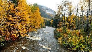
The Sautauriski River originates from Lake Nouvel (length: 1.0 kilometre (0.62 mi); altitude: 768 metres (2,520 ft)), located in the unorganized territory of Lac-Jacques-Cartier, in the La Côte-de-Beaupré Regional County Municipality. [1] The outlet of this lake is located on the east shore has a small dam.
The Sautauriski River takes its source from Nouvel Lake (length: 1.0 kilometre (0.62 mi); altitude: 768 metres (2,520 ft)), located in the unorganized territory of Lac-Jacques-Cartier, in the MRC La Côte-de-Beaupré Regional County Municipality. [1] Its discharge located on the east bank includes a small dam.
From Nouvel Lake, the Sautauriski River flows over 35.1 kilometres (21.8 mi), with a total drop of 489 metres (1,604 ft) according to the following segments:
- 2.3 kilometres (1.4 mi) towards the south-east, in particular by crossing part of lac Archambault (length: 2.2 kilometres (1.4 mi) ; altitude: 759 metres (2,490 ft)) on 1.4 kilometres (0.87 mi), to its mouth;
Upper Sautauriski River course (segment of 17.4 kilometres (10.8 mi))
- 8.4 metres (28 ft) to the south by crossing a marsh area, a small dam, then crossing Sautauriski Lake (length: 5.0 kilometres (3.1 mi); altitude: 744 metres (2,441 ft)) over its full length, to the Sautauriski dam at its mouth;
- 2.0 metres (6 ft 7 in) towards the south-east in an increasingly deep valley and entering the canton of Cauchon, up to the outlet (coming from the north) of Ménard and Handy lakes;
- 7.0 metres (23.0 ft) to the south in a deep valley, up to a bend in the river;
Lower Sautauriski River course (segment of 15.4 kilometres (9.6 mi))
- 5.9 metres (19 ft) first towards the west, then towards the southwest, in a deep valley, up to a bend in the river;
- 2.4 metres (7 ft 10 in) going up first to the north, then to the west, in a deep valley forming a few curves, to the outlet (coming from the north) of Lac Giroux;
- 2.5 metres (8 ft 2 in) south-west in a deep valley, until the confluence of the Chute river (coming from the north);
- 4.6 metres (15 ft) towards the south-west in a deep valley, forming a large loop towards the south-east to circumvent the mountain of Sautauriski, until its mouth. [3]
The Sautauriski River flows on the east bank of the Jacques-Cartier River within the boundaries of the township units of Stoneham-et-Tewkesbury. From this confluence, the current follows the course of the Jacques-Cartier River generally south on 54.7 kilometres (34.0 mi) to the northeast bank of the Saint Lawrence river. [3]
Toponymy
According to the Commission de toponymie du Québec, the Wendat (Huron) chief Nicolas Vincent was the first to mention the toponym, in 1829, before a special committee of the Lower Canada House of Assembly charged with to study the problem of the reduction of arable land in the St. Lawrence Valley and the consequences for Aboriginals of the concession of public land for colonization purposes. On a plan which he then erected of the territory frequented by the Wendats, the chief Vincent inscribed the form Tsoolareske. To the commissioner John Adams in charge of exploring the territory and to whom he serves as a guide, Nicolas Vincent specifies: "This river as well as the mountains are called in Huron Soulariski (the bark is long)".
In a detailed analysis of the toponym presented in his work De Québec au lac Saint-Jean or Sentiers des Laurentides: Sentier des Amérindiens, Sentier des Jésuites (1676-1703), Thomas-Edmond Giroux comes to the conclusion that he is a toponym of the Attikamek or Innu language which he translates as "the forest, it cries", of matow, "to cry" and mistik, "wood". In this place, still according to the author, "the lichens hung on the branches, the" hair of the virgin "of the coureurs de bois, had absorbed and held in suspension an infinity of drops of water from the previous rains and let them fall following days. However, this significance is today strongly questioned.
Marguerite Vincent, in The Huron Nation: Its History, Culture, Spirit (1984), takes up the interpretation of Nicolas Vincent and specifies that the Wendats went to the Sautauriski sector to obtain long barks for manufacturing canoes and basketwork. It derives the toponym of the Wendat language and of the roots atsa or arista, "bark" and eski or etsi, "long". The author also specifies that the Sautauriski was located in Innu territory and constituted a prohibited area for the Wendat. This clarification makes it possible to believe that the toponym could be of Innu origin and come from the word tshinuashkui, from tshinua, "this thing is long" and ushkui, "upper bark which is used for canoes". We should probably forget the translation "bout du museau" mentioned in Nomenclature of geographical names of the province of Quebec, of 1916. [4]
The toponym "Sautauriski River" was formalized on December 5, 1968 at the Place Names Bank of the Commission de toponymie du Québec. [1]

The Moncouche Rive is a tributary of the east bank of the Métabetchouane River, crossing the Laurentides Wildlife Reserve, flowing in the province from Quebec, to Canada. The course of this river crosses the:
The ruisseau Contourné is a tributary of the north shore of the rivière aux Montagnais, flowing near the northern limit in the Laurentides Wildlife Reserve, in the province from Quebec, to Canada. The course crosses:
The Lac aux Rognons is crossed to the northwest by the Métabetchouane River, in the unorganized territory of Lac-Croche, in the La Jacques-Cartier Regional County Municipality, in the administrative region of Capitale-Nationale, in the province of Quebec, in Canada.
The Rivière du Milieu is a tributary of the Launière River, flowing in the unorganized territory of Lac-Jacques-Cartier, in the La Côte-de-Beaupré Regional County Municipality, in the administrative region of Capitale-Nationale, in the province of Quebec, at Canada.
The Cavée River is a freshwater stream, a tributary of the rivière Jacques-Cartier Nord-Ouest, flowing in the unorganized territory of Lac-Jacques-Cartier, in the La Côte-de-Beaupré Regional County Municipality, in the administrative region of Capitale-Nationale, in Quebec, Canada. The course of the river crosses the Jacques-Cartier National Park.
The Rocheuse river is a tributary of the rivière du Malin, located in the unorganized territory of Lac-Jacques-Cartier, in the La Côte-de-Beaupré Regional County Municipality, in the administrative region of Capitale-Nationale, in Quebec, Canada. The course of the river passes in particular in the Laurentides Wildlife Reserve.
The rivière du Malin is a tributary of the Jacques-Cartier River, located in the unorganized territory of Lac-Jacques-Cartier, in the La Côte-de-Beaupré Regional County Municipality, in the administrative region of Capitale-Nationale, in Quebec, Canada. The course of the river passes in particular in the Laurentides Wildlife Reserve.
The Rivière à la Chute is a tributary of the Sautauriski River, flowing in the administrative region of Capitale-Nationale, in Quebec, Canada. This watercourse crosses the unorganized territory of Lac-Jacques-Cartier in the MRC La Côte-de-Beaupré Regional County Municipality and the municipality of Stoneham-et-Tewkesbury, in the MRC of La Jacques-Cartier Regional County Municipality.
Lac à la Chute is a freshwater body on the hydrographic side of rivière à la Chute, located in the unorganized territory of Lac-Jacques-Cartier, in the MRC La Côte-de-Beaupré Regional County Municipality, Quebec, Canada.
The Lac des Alliés is a freshwater body crossed west by the Rocheuse River, located in the unorganized territory of Lac-Jacques-Cartier, in the La Côte-de-Beaupré Regional County Municipality, in administrative region of Capitale-Nationale, in province of Quebec, in Canada.
The lac à l'Épaule is a freshwater body crossed from north to south by the Rivière à l'Épaule, in Jacques-Cartier National Park. This lake is located entirely in the unorganized territory of Lac-Jacques-Cartier, in the La Côte-de-Beaupré Regional County Municipality, administrative region of Capitale-Nationale, in province of Quebec, in Canada.
The Rivière à l'Épaule is a tributary of the Jacques-Cartier River, flowing in the administrative region of Capitale-Nationale, in Quebec, Canada. The course of the river crosses the unorganized territory of Lac-Jacques-Cartier in the La Côte-de-Beaupré Regional County Municipality, as well as the township municipality unis de Stoneham-et-Tewkesbury, located in the MRC La Jacques-Cartier Regional County Municipality.
The Montagne de l'Épaule peaks at 460 metres (1,510 ft) in Jacques-Cartier National Park, in the municipality of Stoneham-et-Tewkesbury, in La Jacques-Cartier Regional County Municipality, in the administrative region of Capitale-Nationale, in Quebec, Canada.
The Lac Archambault is a freshwater body crossed from north to south by the Sautauriski River, flowing in the unorganized territory of Lac-Jacques-Cartier, in the regional county municipality (MRC) La Côte-de-Beaupré Regional County Municipality, in the administrative region of Capitale-Nationale, in province of Quebec, in Canada.

The Rivière Cachée is a tributary of the Jacques-Cartier River, flowing in the administrative region of Capitale-Nationale, in Quebec, Canada. The course of the river crosses the unorganized territory of Lac-Jacques-Cartier in the La Côte-de-Beaupré Regional County Municipality, as well as the township municipality unis de Stoneham-et-Tewkesbury, located in the MRC La Jacques-Cartier Regional County Municipality.

The rivière des Hurons is a river flowing in the heart of the municipality of Cantons-unis de Stoneham-et-Tewkesbury, located north of Quebec (city), in the La Jacques-Cartier Regional County Municipality, in the administrative region of Capitale-Nationale, in province from Quebec, to Canada.
The Smith River is a tributary of the east bank of the Montmorency River. It flows in the unorganized territory of Lac-Jacques-Cartier, in the La Côte-de-Beaupré Regional County Municipality, in the administrative region of Capitale-Nationale, in the province of Quebec, in Canada.
The Petite rivière Smith is a tributary of the northwest shore of the Smith River. This stream flows in the unorganized territory of Lac-Jacques-Cartier, in the La Côte-de-Beaupré Regional County Municipality, in the administrative region of Capitale-Nationale, in the province of Quebec, in Canada.
The Petite rivière Savane is a tributary of the Sainte-Anne River, flowing on the north bank of the Saint Lawrence River, in the territory unorganized from Lac-Jacques-Cartier, in the La Côte-de-Beaupré Regional County Municipality, in the administrative region of Capitale-Nationale, in the province of Quebec, in Canada.
The Rivière Brûlé is a tributary of the Sainte-Anne River, flowing on the north bank of the Saint Lawrence River, in the non-territory organized from Lac-Jacques-Cartier, in the La Côte-de-Beaupré Regional County Municipality, in the administrative region of Capitale-Nationale, in the province of Quebec, in Canada.

