Lusatia is a region in Central Europe. The region is the home of the ethnic group of Sorbs, a small West Slavic people. It stretches from the Bóbr and Kwisa rivers in the east to the Pulsnitz and Black Elster in the west, today located within the German states of Saxony and Brandenburg as well as in the Lower Silesian and Lubusz voivodeships of western Poland.

The Ore Mountains or Ore Mountain Range in Central Europe have formed a natural border between Saxony and Bohemia for around 800 years, from the 12th to the 20th centuries. Today, the border between Germany and the Czech Republic runs just north of the main crest of the mountain range. The highest peaks are the Klínovec, which rises to 1,244 metres (4,081 ft) above sea level and the Fichtelberg.

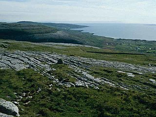
Saxon Switzerland is a hilly climbing area and national park around the Elbe valley south-east of Dresden in Saxony, Germany. Together with the Bohemian Switzerland in the Czech Republic it forms the Elbe Sandstone Mountains.

The Lusatian Highlands or Lusatian Hills form a hilly region in Germany and the Czech Republic. A western extension of the Sudetes range, it is located on the border of the German state of Saxony with the Czech Bohemian region. It is one of the eight natural landscapes of Upper Lusatia.

The North German Plain or Northern Lowland is one of the major geographical regions of Germany. It is the German part of the North European Plain. The region is bounded by the coasts of the North Sea and the Baltic Sea to the north and Germany's Central Uplands to the south.
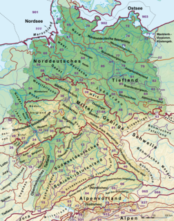
This division of Germany into major natural regions takes account primarily of geomorphological, geological, hydrological, and pedological criteria in order to divide the country into large, physical units with a common geographical basis. Political boundaries play no part in this, apart from defining the national border.

The Saxon Uplands, Saxon Hills or Ore Mountain Foreland is a strip of countryside of about 200 m to 500 m above sea level (NN) high, in the German state of Saxony, that lies immediately north of the German Ore Mountains and runs mainly through the areas of Zwickauer Land, Zwickau, Chemnitzer Land, Chemnitz, Mittelsachsen and the country south of Dresden. It borders on the Upper Pleißeland to the extreme west, the Ore Mountain Basin in the south and the Mulde Loess Hills to the north and east.

The West Hesse Highlands, also known as the West Hessian Lowlands and Highlands, refers to a heavily forested region of the Central Uplands in Germany that lies mostly within the state of Hesse, between those elements of the Rhenish Massif right of the Rhine in the west, the Weser Uplands to the north, the Hessian Central Uplands to the east and the Wetterau to the south.
The Saxon-Bohemian Chalk Sandstone Region is a natural region in south Saxony on the southern border with the Czech Republic. It forms part of the northern perimeter of the Bohemian Massif and comprises Saxon Switzerland, the German part of the Elbsandsteingebirge and the Zittau Hills, a small section of the Lusatian Mountains on German soil. Because the boundary between the Elbsandsteingebirge and the Lusatian Uplands is on Czech territory, the two natural regions are physically separated.
The Saxon Highlands and Uplands refer to a natural region mainly in the south of Saxony with small elements also in southeast Thuringia and northeast Bavaria. It comprises, from (south)west to (north)east, of the Vogtland, the Ore Mountains, Saxon Switzerland, the Upper Lusatian Plateau and the Zittau Hills.

The Eastern Ore Mountains form a natural region of Saxony that covers the eastern part of the Saxon Ore Mountains range. Together with the Western and Central Ore Mountains, it is part of the larger Saxon Highlands and Uplands region. Its southern continuation beyond the German border covers an area of roughly the same extent in the Czech Republic.
The Central or Middle Ore Mountains is a natural region that forms the central-western part of the Ore Mountains in the German federal state of Saxony. It is part of the overarching unit, the Saxon Highlands and Uplands. It forms the eastern part of the former major units, the Lower Western Ore Mountains and Upper Western Ore Mountains and is separated from the Eastern Ore Mountains in the east by the (included) valley of the Flöha, and from the Western Ore Mountains in the west by the (excluded) valley of the Schwarzwasser and, below its mouth, by the Zwickauer Mulde.
The Western Ore Mountains is a natural region that forms the westernmost part of the Ore Mountains in the German federal state of Saxony. It is also part of the major landscape unit known as the Saxon Highlands and Uplands. It extends eastwards to include the valley of the Schwarzwasser, and, below its mouth, that of the Zwickauer Mulde, and incorporates the western parts of the former major units known as the Lower and Upper Western Ore Mountains, no. 423, as well as the Southern Slopes of the Ore Mountains, no. 420.

The Leipzig Bay(German: Leipziger Tieflandsbucht) or Leipzig Basin or Saxon Lowland or Saxon Bay is a relatively lakeless and highly fertile landscape in Central Germany, in northwestern Saxony and southeastern Saxony-Anhalt.
Eastern Upper Lusatia is a natural region in Saxony and, in a broader sense, part of the Western Sudetes range including the Lower Silesian Voivodeship. The current Saxon division of natural regions view the region as part of the Saxon Loess Fields and divides it into 12 subdivisions at the level of meso-geochores.

The West Lusatian Hill Country and Uplands, sometimes just the West Lusatian Hills, is a natural region in Saxony. It is divided into the West Lusatian Foothills in the east and the Lusatian Plateau in the west and forms the westernmost extremity of the Sudetes range.

The classification of natural regions of Saxony shown here was produced between 1994 and 2001 by a working group called "Ecosystem and Regional Character" at the Saxonian Academy of Sciences in Leipzig as part of the research and development project "Natural Regions and Natural Region Potential of the Free State of Saxony" at a scale of 1:50,000 as the basis for the rural development and regional planning. This was also supported by the Saxon State Ministry of the Environment and Agriculture and the Saxon Ministry of the Interior.