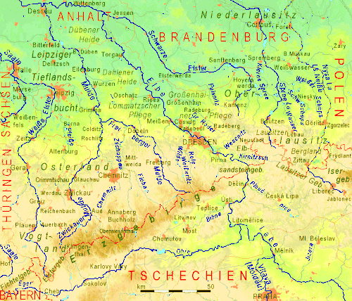
Lusatia is a historical region in Central Europe, split between Germany and Poland. Lusatia stretches from the Bóbr and Kwisa rivers in the east to the Pulsnitz and Black Elster rivers in the west, and is located within the German states of Saxony and Brandenburg as well as in the Polish voivodeships of Lower Silesia and Lubusz. Lusatia's central rivers are the Spree and the Lusatian Neisse, which constitutes the border between Germany and Poland since 1945. The Lusatian Mountains, separate Lusatia from Bohemia in the south. Lusatia is traditionally divided into Upper Lusatia and Lower Lusatia.
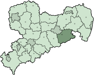
The Sächsische Schweiz is a former district (Kreis) in the south of Saxony, Germany. Neighboring districts were Weißeritzkreis, the district-free city Dresden and the districts Kamenz and Bautzen. To the south it borders the Czech Republic.

Saxon Switzerland is a hilly climbing area and national park in the Elbe Sandstone Mountains, located around the Elbe valley south-east of Dresden in Saxony, Germany. Together with Bohemian Switzerland in the Czech Republic, the region is known as Saxon-Bohemian Switzerland.

The Royal Saxon State Railways were the state-owned railways operating in the Kingdom of Saxony from 1869 to 1918. From 1918 until their merger into the Deutsche Reichsbahn the title 'Royal' was dropped and they were just called the Saxon State Railways.

This division of Germany into major natural regions takes account primarily of geomorphological, geological, hydrological, and pedological criteria in order to divide the country into large, physical units with a common geographical basis. Political boundaries play no part in this, apart from defining the national border.
The Saxon Loess Fields refer to a natural region that lies mainly within the state of Saxony in central Germany. In addition, small areas of this region extend to the northwest and west into Saxony-Anhalt, to the southeast into Thuringia and to the northeast into Brandenburg. It more-or-less combines the BfN's major regions listed as D19 Saxon Upland and Ore Mountain Foreland, and D14, Upper Lusatia (Oberlausitz); only the range of Central Uplands hills, the Lusatian Mountains, has been excluded and instead forms part of the Saxon Highlands and Uplands.
The Saxon-Bohemian Chalk Sandstone Region is a natural region in south Saxony on the southern border with the Czech Republic. It forms part of the northern perimeter of the Bohemian Massif and comprises Saxon Switzerland, the German part of the Elbsandsteingebirge and the Zittau Hills, a small section of the Lusatian Mountains on German soil. Because the boundary between the Elbsandsteingebirge and the Lusatian Uplands is on Czech territory, the two natural regions are physically separated.
The Saxon Highlands and Uplands refer to a natural region mainly in the south of Saxony with small elements also in southeast Thuringia and northeast Bavaria. It comprises, from (south)west to (north)east, of the Vogtland, the Ore Mountains, Saxon Switzerland, the Upper Lusatian Plateau and the Zittau Hills.
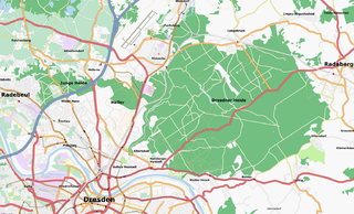
The Dresden Heath is a large forest in the city of Dresden, Germany. The heath is the most important recreation area in the city and is also actively forested. Approximately 6,133 hectares of the Dresden Heath are designated as a nature preserve, making it one of the largest municipal forests in Germany by area. Though mainly agricultural areas border the forest in the east, in all other directions the Dresden Heath is bordered by districts of the city and reaches nearly to the city centre in the southwest.

The Eastern Ore Mountains form a natural region of Saxony that covers the eastern part of the Saxon Ore Mountains range. Together with the Western and Central Ore Mountains, it is part of the larger Saxon Highlands and Uplands region. Its southern continuation beyond the German border covers an area of roughly the same extent in the Czech Republic.
The Western Ore Mountains is a natural region that forms the westernmost part of the Ore Mountains in the German state of Saxony. It is also part of the major landscape unit known as the Saxon Highlands and Uplands. It extends eastwards to include the valley of the Schwarzwasser, and, below its mouth, that of the Zwickauer Mulde, and incorporates the western parts of the former major units known as the Lower and Upper Western Ore Mountains, no. 423, as well as the Southern Slopes of the Ore Mountains, no. 420.

The Leipzig Bay(German: Leipziger Tieflandsbucht) or Leipzig Basin or Saxon Lowland or Saxon Bay is a relatively lakeless and highly fertile landscape in Central Germany, in northwestern Saxony and southeastern Saxony-Anhalt.

The Central Saxon Hills, is a region of Hügelland with indistinct boundaries in the centre of the German state of Saxony.

Eastern Upper Lusatia is a natural region in Saxony and, in a broader sense, part of the Western Sudetes range including the Lower Silesian Voivodeship. The current Saxon division of natural regions view the region as part of the Saxon Loess Fields and divides it into 12 subdivisions at the level of meso-geochores.

The West Lusatian Hill Country and Uplands, sometimes just the West Lusatian Hills, is a natural region in Saxony. It is divided into the West Lusatian Foothills in the east and the Lusatian Plateau in the west and forms the westernmost extremity of the Sudetes range.
The Upper Lusatian Heath and Pond Landscape is a natural region in Saxony. It runs from a line between Wittichenau and Kamenz for roughly 60 kilometres in an east-west direction as far as the River Neisse. Its width between the bordering natural regions of the Upper Lusatian Gefilde and Eastern Upper Lusatia to the south and the Muskau Heath and Upper Lusatian Mining Region to the north is between 15 and 20 kilometres.

The Upper Lusatian Gefilde is a natural region in Saxony near the German tripoint with the Czech Republic and Poland. It is considered part of the Saxon Loess Fields and the Western Sudetes range. Gefilde is German for "fields" or "country".

The Saxon-Lower Lusatian Heathland is a natural region in the German state of Saxony. The current natural region division of the Free State of Saxony groups landscape units of the upper geochore or sub-regional level into three "Saxon natural regions" to produce a large-scale classification. These are part of higher order (cross-border) natural regions, whereas the landscape units previously used described areas that were largely confined within the borders of Saxony.
Geochores are relatively large landscape areas with similar – but owing to their size not fully uniform – characteristics. They therefore consist of a tapestry of smaller landscape units, which can be hierarchically grouped: