Saxon-Lower Lusatian Heathland

Last updated
Saxon-Lower Lusatian Heathland
Native NameSächsisch-Niederlausitzer Heideland
Classification Natural regions of the Free State of Saxony
Natural region Saxon-Lower Lusatian Heathland
State(s) Saxony
Country Germany
The Saxon-Lower Lusatian Heathland within Saxony Naturregion Sachsisch-Niederlausitzer Heideland.jpg
The Saxon-Lower Lusatian Heathland within Saxony

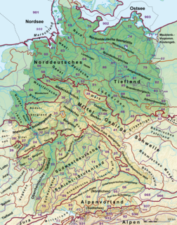
The Saxon-Lower Lusatian Heathland (German : Sächsisch-Niederlausitzer Heideland) is a natural region in the German state of Saxony. The current natural region division of the Free State of Saxony groups landscape units of the upper geochore or sub-regional level (so-called "macro-geochores") into three "Saxon natural regions" to produce a large-scale classification. These are part of higher order (cross-border) natural regions, whereas the landscape units previously used described areas that were largely confined within the borders of Saxony.

German language West Germanic language

German is a West Germanic language that is mainly spoken in Central Europe. It is the most widely spoken and official or co-official language in Germany, Austria, Switzerland, South Tyrol (Italy), the German-speaking Community of Belgium, and Liechtenstein. It is also one of the three official languages of Luxembourg and a co-official language in the Opole Voivodeship in Poland. The languages which are most similar to German are the other members of the West Germanic language branch: Afrikaans, Dutch, English, the Frisian languages, Low German/Low Saxon, Luxembourgish, and Yiddish. There are also strong similarities in vocabulary with Danish, Norwegian and Swedish, although those belong to the North Germanic group. German is the second most widely spoken Germanic language, after English.

Natural region region distinguished by its common natural features of geography, geology, and climate

A natural region is a basic geographic unit. Usually it is a region which is distinguished by its common natural features of geography, geology, and climate.

Saxony State in Germany

Saxony, officially the Free State of Saxony, is a landlocked federal state of Germany, bordering the federal states of Brandenburg, Saxony Anhalt, Thuringia, and Bavaria, as well as the countries of Poland and the Czech Republic. Its capital is Dresden, and its largest city is Leipzig.

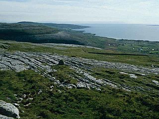
The Saxon-Lower Lusatian Heathland forms the southernmost extent of the North German Plain in eastern Germany. It comprises two separate regions on the northern edge of Saxony and covers about 20% of the state's area. Whilst its boundaries in the north and east are based on political boundaries, due to the limitations of the research and data collation that underpinned the classification, its remaining boundaries are based on physical geographic considerations and are identical with their subordinate natural regions. The western part of the Heathland, roughly between the rivers Mulde and Große Röder, comprises the macro-geochores of the Düben-Dahlen Heath, the Elbe-Elster Lowland and, in the extreme northwest, a small part of the Bitterfeld Mining District, the bulk of which lies in the Saxony-Anhalt and is referred to as the Bitterfeld Mining Region (Tagebauregion Bitterfeld) in the regional landscape planning of that state. [1] The eastern part of the Heathland covers the Königsbrück-Ruhland Heaths, the Upper Lusatian Heath and Pond Landscape, the Upper Lusatian Mining District, the Muskau Heath, the Lusatian Border Wall and, in the extreme north, a small element of the Cottbus Sand Plateau, which lies mainly within the state of Brandenburg. Between the two halves of this natural region is the Großenhainer Pflege, which is counted as part of the Saxon Loess Fields due to its natural regional characteristics.

North German Plain plain in Germany

The North German Plain or Northern Lowland is one of the major geographical regions of Germany. It is the German part of the North European Plain. The region is bounded by the coasts of the North Sea and the Baltic Sea to the north and Germany's Central Uplands to the south.

Physical geography The study of processes and patterns in the natural environment

Physical geography is one of the two major sub-fields of geography. Physical geography is the branch of natural science which deals with the study of processes and patterns in the natural environment like the atmosphere, hydrosphere, biosphere, and geosphere, as opposed to the cultural or built environment, the domain of human geography.

Mulde river in Saxony and Saxony-Anhalt, Germany

The Mulde is a river in Saxony and Saxony-Anhalt, Germany. It is a left tributary of the Elbe and is 124 kilometres (77 mi) long.

Characteristic and unifying features of the natural regions grouped within the Saxon-Lower Lusatian Heathland are soils that are poor in nutrients lying on thick, unconsolidated, Ice Age sediments, with an abundance of groundwater and underground deposits of brown coal. This is a so-called Old Drift landscape, in which erosion and soil-forming processes have been around for a very long time. The surface landforms that arose in the Pleistocene epoch are therefore heavily eroded or even levelled, the soils are heavily decalcified and, in places, strongly acidified. The low agricultural utility across wide areas resulted in a relatively sparse population and, especially in the 20th century, it was extensively used for military training purposes. Large areas also became an industrial landscape as a result of open-cast, lignite mining.

Sediment Particulate solid matter that is deposited on the surface of land

Sediment is a naturally occurring material that is broken down by processes of weathering and erosion, and is subsequently transported by the action of wind, water, or ice or by the force of gravity acting on the particles. For example, sand and silt can be carried in suspension in river water and on reaching the sea bed deposited by sedimentation and if buried, may eventually become sandstone and siltstone.

Groundwater water located beneath the ground surface

Groundwater is the water present beneath Earth's surface in soil pore spaces and in the fractures of rock formations. A unit of rock or an unconsolidated deposit is called an aquifer when it can yield a usable quantity of water. The depth at which soil pore spaces or fractures and voids in rock become completely saturated with water is called the water table. Groundwater is recharged from and eventually flows to the surface naturally; natural discharge often occurs at springs and seeps, and can form oases or wetlands. Groundwater is also often withdrawn for agricultural, municipal, and industrial use by constructing and operating extraction wells. The study of the distribution and movement of groundwater is hydrogeology, also called groundwater hydrology.

Old and Young Drift are geographic names given to the morainic landscapes that were formed in Central Europe; the Old Drift during the older ice ages and the Young Drift during the latest glaciations – the Weichselian in North Germany and the Würm in the Alps. Their landforms are quite different. Areas of Old Drift have been heavily flattened and transformed as a result of geomorphic processes such as denudation and erosion, whilst areas of Young Drift have largely retained their original shape. Whilst the majority of Old Drift moraines were formed during the Saale glaciation about 130,000 to 140,000 years ago, the Young Drift moraines in Central Europe are only about 15,000 to 20,000 years old. The terms Old and Young Drift are used for all elements of the glacial series even though the meltwater deposits and landforms are not strictly moraines.

Relatively un-fragmented areas, numerous water bodies and wetland sites and extensive nutrient-poor open land, amongst other features, have led to a high conservation value being placed on the region, which contains about 71% of Saxony's nature reserves.

Related Research Articles

Saxony-Anhalt State in Germany

Saxony-Anhalt is a state of Germany.

Lusatia Place

Lusatia is a region in Central Europe. The region is the home of the ethnic group of Sorbs, a small West Slavic people. It stretches from the Bóbr and Kwisa rivers in the east to the Pulsnitz and Black Elster in the west, today located within the German states of Saxony and Brandenburg as well as in the Lower Silesian and Lubusz voivodeships of western Poland.

Saxon Switzerland mountain range

Saxon Switzerland is a hilly climbing area and national park around the Elbe valley south-east of Dresden in Saxony, Germany. Together with the Bohemian Switzerland in the Czech Republic it forms the Elbe Sandstone Mountains.

Elbe Sandstone Mountains mountains in Germany

The Elbe Sandstone Mountains, also called the Elbe sandstone highlands is a mountain range straddling the border between the state of Saxony in southeastern Germany and the North Bohemian region of the Czech Republic, with about three-quarters of the area lying on the German side. The mountains are also referred to as Saxon Switzerland and Bohemian Switzerland in both German and Czech or simply combined as Saxon-Bohemian Switzerland. In both countries, the mountain range has been declared a national park. The name derives from the sandstone which was carved by erosion. The river Elbe breaks through the mountain range in a steep and narrow valley.

Natural regions of Germany

This division of Germany into major natural regions takes account primarily of geomorphological, geological, hydrological, and pedological criteria in order to divide the country into large, physical units with a common geographical basis. Political boundaries play no part in this, apart from defining the national border.

The Saxon Loess Fields refer to a natural region that lies mainly within the state of Saxony in central Germany. In addition, small areas of this region extend to the northwest and west into Saxony-Anhalt, to the southeast into Thuringia and to the northeast into Brandenburg. It more-or-less combines the BfN's major regions listed as D19 Saxon Upland and Ore Mountain Foreland, and D14, Upper Lusatia (Oberlausitz); only the range of Central Uplands hills, the Lusatian Mountains, has been excluded and instead forms part of the Saxon Highlands and Uplands.

Dresden Basin valley

The Dresden Basin is a roughly 45 km long and 10 km wide area of the Elbe Valley between the towns of Pirna and Meißen. The city of Dresden lies in the Dresden Basin.

The Saxon-Bohemian Chalk Sandstone Region is a natural region in south Saxony on the southern border with the Czech Republic. It forms part of the northern perimeter of the Bohemian Massif and comprises Saxon Switzerland, the German part of the Elbsandsteingebirge and the Zittau Hills, a small section of the Lusatian Mountains on German soil. Because the boundary between the Elbsandsteingebirge and the Lusatian Uplands is on Czech territory, the two natural regions are physically separated.

Dresden Heath forest in the city of Dresden, Germany

The Dresden Heath is a large forest in the city of Dresden. The heath is the most important recreation area in the city and is also actively forested. Approximately 6,133 hectares of the Dresden Heath are designated as a nature preserve, making it one of the largest municipal forests in Germany by area. Though mainly agricultural areas border the forest in the east, in all other directions the Dresden Heath is bordered by districts of the city and reaches nearly to the city centre in the southwest.

Eastern Ore Mountains

The Eastern Ore Mountains form a natural region of Saxony that covers the eastern part of the Saxon Ore Mountains range. Together with the Western and Central Ore Mountains, it is part of the larger Saxon Highlands and Uplands region. Its southern continuation beyond the German border covers an area of roughly the same extent in the Czech Republic.

Düben Heath landscape in Saxony and Saxony-Anhalt, Germany

The Düben Heath is a landscape in Germany in eastern Saxony-Anhalt and northern Saxony, between the rivers Elbe and the Mulde, on the northern edge of the Leipzig Bay.

Wendland and Altmark, named after the German regions of Wendland and Altmark, is the name of a natural regional major landscape unit group in Lower Saxony and Saxony-Anhalt, North Germany. In the Handbook of Natural Region Divisions of Germany it is given serial number 86, the Bundesamt für Naturschutz gives the same region the serial number D29.

Eastern Upper Lusatia is a natural region in Saxony and, in a broader sense, part of the Western Sudetes range including the Lower Silesian Voivodeship. The current Saxon division of natural regions view the region as part of the Saxon Loess Fields and divides it into 12 subdivisions at the level of meso-geochores.

West Lusatian Hill Country and Uplands

The West Lusatian Hill Country and Uplands, sometimes just the West Lusatian Hills, is a natural region in Saxony. It is divided into the West Lusatian Foothills in the east and the Lusatian Plateau in the west and forms the westernmost extremity of the Sudetes range.

The Upper Lusatian Heath and Pond Landscape is a natural region in Saxony. It runs from a line between Wittichenau and Kamenz for roughly 60 kilometres in an east-west direction as far as the River Neisse. Its width between the bordering natural regions of the Upper Lusatian Gefilde and Eastern Upper Lusatia to the south and the Muskau Heath and Upper Lusatian Mining Region to the north is between 15 and 20 kilometres.

Upper Lusatian Gefilde

The Upper Lusatian Gefilde is a natural region in Saxony near the German tripoint with the Czech Republic and Poland. It is considered part of the Saxon Loess Fields and the western Sudetes range. Gefilde is German for "fields" or "country".

Natural regions of Saxony

The classification of natural regions of Saxony shown here was produced between 1994 and 2001 by a working group called "Ecosystem and Regional Character" at the Saxonian Academy of Sciences in Leipzig as part of the research and development project "Natural Regions and Natural Region Potential of the Free State of Saxony" at a scale of 1:50,000 as the basis for the rural development and regional planning. This was also supported by the Saxon State Ministry of the Environment and Agriculture and the Saxon Ministry of the Interior.

The Muskau Heath, is a natural region in Saxony that lies south of the town of Bad Muskau. It has an area of 400 square kilometres.

Central Brandenburg Plateaux and Lowlands

The Central Brandenburg Plateaux and Lowlands form a natural region in the German state of Brandenburg and in parts of southwest Berlin and the east of Saxony-Anhalt. They are major unit group 81 in the system of natural regions of Germany and part of the East German Plateaux and Heathlands. The Brandenburg portion of the Central Brandenburg Plateaux and Lowlands is largely coincident with the natural region designated as the Central March in the structural atlas of the state of Brandenburg.

References

  1. Map of landscape units in Saxony-Anhalt at www.sachsen-anhalt.de

Sources

International Standard Book Number Unique numeric book identifier

The International Standard Book Number (ISBN) is a numeric commercial book identifier which is intended to be unique. Publishers purchase ISBNs from an affiliate of the International ISBN Agency.

Coordinates: 51°26′00″N14°15′00″E / 51.4333°N 14.2500°E / 51.4333; 14.2500

Geographic coordinate system Coordinate system

A geographic coordinate system is a coordinate system that enables every location on Earth to be specified by a set of numbers, letters or symbols. The coordinates are often chosen such that one of the numbers represents a vertical position and two or three of the numbers represent a horizontal position; alternatively, a geographic position may be expressed in a combined three-dimensional Cartesian vector. A common choice of coordinates is latitude, longitude and elevation. To specify a location on a plane requires a map projection.