Related Research Articles

Lusatia is a historical region in Central Europe, split between Germany and Poland. Lusatia stretches from the Bóbr and Kwisa rivers in the east to the Pulsnitz and Black Elster rivers in the west, and is located within the German states of Saxony and Brandenburg as well as in the Polish voivodeships of Lower Silesia and Lubusz. Lusatia's central rivers are the Spree and the Lusatian Neisse, which constitutes the border between Germany and Poland since 1945. The Lusatian Mountains, separate Lusatia from Bohemia in the south. Lusatia is traditionally divided into Upper Lusatia and Lower Lusatia.

Kamenz or Kamjenc (Sorbian) is a town in the district of Bautzen in Saxony, Germany. Until 2008 it was the administrative seat of Kamenz District. The town is known as the birthplace of the philosopher and poet Gotthold Ephraim Lessing and Bruno Hauptmann, convicted kidnapper of the Lindbergh baby. It lies north-east of the major city of Dresden.

Bad Muskau is a spa town in the historic Upper Lusatia region in Germany, at the border with Poland. It is part of the Görlitz district in the State of Saxony.
Lower Lusatia is a historical region in Central Europe, stretching from the southeast of the German state of Brandenburg to the southwest of Lubusz Voivodeship in Poland. Like adjacent Upper Lusatia in the south, Lower Lusatia is a settlement area of the West Slavic Sorbs whose endangered Lower Sorbian language is related to Upper Sorbian and Polish.

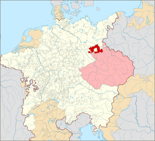
Upper Lusatia is a historical region in Germany and Poland. Along with Lower Lusatia to the north, it makes up the region of Lusatia, named after the Slavic Lusici tribe. Both parts of Lusatia are home to the West Slavic minority group of the Sorbs.

Lower Silesia is the northwestern part of the historical and geographical region of Silesia; Upper Silesia is to the southeast.

The Lusatian Lake District is a chain of artificial lakes under construction in Germany across the north-eastern part of Saxony and the southern part of Brandenburg. Through flooding as a part of an extensive regeneration programme, several decommissioned lignite opencast mines are in the process of being transformed into Europe's largest artificial lake district. However, the requirements of the project, especially the necessary water resources, are controversial.

Przewóz is a village in Żary County, Lubusz Voivodeship, in western Poland. It is located in the historic Lower Silesia region on the eastern shore of the Lusatian Neisse river, which today marks the border with Germany. Przewóz is the seat of the gmina called Gmina Przewóz. The village has a population of about 850.

The Diocese of Görlitz is a diocese of the Roman Catholic church in Germany. The current ordinary is Wolfgang Ipolt
Görlitz district is a district (Kreis) in Saxony, and the easternmost in Germany. It is named after its capital Görlitz. It borders the district of Bautzen, the state of Brandenburg, Poland and the Czech Republic.

This division of Germany into major natural regions takes account primarily of geomorphological, geological, hydrological, and pedological criteria in order to divide the country into large, physical units with a common geographical basis. Political boundaries play no part in this, apart from defining the national border.
The Saxon Highlands and Uplands refer to a natural region mainly in the south of Saxony with small elements also in southeast Thuringia and northeast Bavaria. It comprises, from (south)west to (north)east, of the Vogtland, the Ore Mountains, Saxon Switzerland, the Upper Lusatian Plateau and the Zittau Hills.
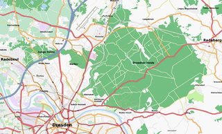
The Dresden Heath is a large forest in the city of Dresden, Germany. The heath is the most important recreation area in the city and is also actively forested. Approximately 6,133 hectares of the Dresden Heath are designated as a nature preserve, making it one of the largest municipal forests in Germany by area. Though mainly agricultural areas border the forest in the east, in all other directions the Dresden Heath is bordered by districts of the city and reaches nearly to the city centre in the southwest.

Eastern Upper Lusatia is a natural region in Saxony and, in a broader sense, part of the Western Sudetes range including the Lower Silesian Voivodeship. The current Saxon division of natural regions view the region as part of the Saxon Loess Fields and divides it into 12 subdivisions at the level of meso-geochores.
The term West Lusatia was coined in the 1950s for the old counties of Hoyerswerda, Kamenz and Bischofswerda – mainly in order to make the Museum of West Lusatia into a centrepoint. Culturally and historically, West Lusatia corresponds to western Upper Lusatia, including part of the Brandenburg county of Oberspreewald-Lausitz, between the rivers Pulsnitz and Black Elster.

The West Lusatian Hill Country and Uplands, sometimes just the West Lusatian Hills, is a natural region in Saxony. It is divided into the West Lusatian Foothills in the east and the Lusatian Plateau in the west and forms the westernmost extremity of the Sudetes range.

The classification of natural regions of Saxony shown here was produced between 1994 and 2001 by a working group called "Ecosystem and Regional Character" at the Saxonian Academy of Sciences in Leipzig as part of the research and development project "Natural Regions and Natural Region Potential of the Free State of Saxony" at a scale of 1:50,000 as the basis for the rural development and regional planning. This was also supported by the Saxon State Ministry of the Environment and Agriculture and the Saxon Ministry of the Interior.

The Saxon-Lower Lusatian Heathland is a natural region in the German state of Saxony. The current natural region division of the Free State of Saxony groups landscape units of the upper geochore or sub-regional level into three "Saxon natural regions" to produce a large-scale classification. These are part of higher order (cross-border) natural regions, whereas the landscape units previously used described areas that were largely confined within the borders of Saxony.
The Lusatian Border Ridge, also called the Lusatian Border Wall, is a natural region in Saxony and South Brandenburg. It lies not far from the town of Weißwasser and is bounded in the south and west by the Muskau Heath and in the north by the Cottbus Sand Plateau. To the west it transitions at the River Dahme into the Lower Fläming; to the east it continues on the far side of the border river of the Lusatian Neisse into Poland as the Wał Trzebnicki as far as the River Bóbr.
References
- ↑ Development and Perspectives of Landscape Ecology edited by O. Bastian, Uta Steinhardt, p. 181. (2002)
- ↑ World of Mining Vol. 58, GDMB Medienverlag, 2006, p. 376.
- ↑ Development of European landscapes, conference proceedings, Vol. 1, University of Tartu, Institute of Geography, 2001, pp. 253 and 257.
- ↑ Soil Organisms Vol. 81 (3), 2009, The 14th World Congress of Myriapodology, Staatliches Museum für Naturkunde Görlitz, p. v.
- ↑ Abhandlungen und Berichte des Naturkundemuseums Görlitz, Vol. 73, Das Museum, 2001, p. 79.