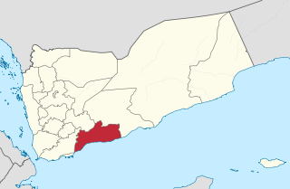
Abyan is a governorate of Yemen. The Abyan region was historically part of the Fadhli Sultanate. It was a base to the Aden-Abyan Islamic Army militant group. Its capital is the city of Zinjibar. This governorate is noted for its agriculture, in particular the cultivation of date palms and animal husbandry.
Al Qaflah District is a district of the 'Amran Governorate, Yemen. As of 2003, the district had a population of 36,722 inhabitants.

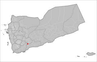
Sarar District is a district of the Abyan Governorate, Yemen. As of 2003, the district had a population of 15,093 inhabitants.
Sibah District is a district of the Abyan Governorate, Yemen. As of 2003, the district had a population of 15,996 inhabitants.
Al Mansuriyah District is a district of the Al Hudaydah Governorate, Yemen. As of 2003, the district had a population of 44,744 inhabitants.
Bayt al-Faqih District is a district of the Al Hudaydah Governorate, Yemen. As of 2003, the district had a population of 241,300 inhabitants.
Bura District is a district of the Al Hudaydah Governorate, Yemen. As of 2003, the district had a population of 45,116 inhabitants.
Man'ar District is a district of the Al Mahrah Governorate, Yemen. As of 2003, the district had a population of 5,388 inhabitants.
Shahan District is a district of the Al Mahrah Governorate, Yemen. As of 2003, the district had a population of 3,152 inhabitants.
Az'zal District is a district of the Sana'a, Yemen. As of 2003, it had a population of 115,054.
Washhah District is a district of the Hajjah Governorate, Yemen. As of 2003, the district had a population of 62,617 people.

Rumah District is a district of the Hadhramaut Governorate, Yemen. As of 2021, the district had a population of 10,080 inhabitants.
Radfan District is a district of the Lahij Governorate, Yemen. As of 2003, the district had a population of 45,570 people.
Harib District is a district of the Ma'rib Governorate, Yemen. As of 2003, the district had a population of 33,663 inhabitants.
Sirwah District is a district of the Ma'rib Governorate, Yemen. As of 2003, the district had a population of 19,939 inhabitants.
Baqim District is a district of the Sa'dah Governorate, Yemen. As of 2003, the district had a population of 22,965 people.
Kitaf wa Al Boqe'e District is a district of the Sa'dah Governorate, Yemen. As of 2003, the district had a population of 43,034 inhabitants.
Qatabir District is a district of the Sa'dah Governorate, Yemen. As of 2003, the district had a population of 22,658 inhabitants.

Arhab District is a district of the Sana'a Governorate, Yemen. As of 2003, the district had a population of 90,038 inhabitants.

Bander Beila, also known as Bander Beyla is a district in the northeastern Bari region of Puntland It is an old town near the Indian Ocean and is mountainous with old buildings. The Beyla region is a hybrid of fishing and a small number have farms. It is a peaceful region with little police
