
Alexander Island, which is also known as Alexander I Island, Alexander I Land, Alexander Land, Alexander I Archipelago, and Zemlja Alexandra I, is the largest island of Antarctica. It lies in the Bellingshausen Sea west of Palmer Land, Antarctic Peninsula from which it is separated by Marguerite Bay and George VI Sound. George VI Ice Shelf entirely fills George VI Sound and connects Alexander Island to Palmer Land. The island partly surrounds Wilkins Sound, which lies to its west. Alexander Island is about 390 kilometres (240 mi) long in a north–south direction, 80 kilometres (50 mi) wide in the north, and 240 kilometres (150 mi) wide in the south. Alexander Island is the second largest uninhabited island in the world, after Devon Island.
The Argentina Range is a mountain range of rock peaks and bluffs, 68 km (42 mi) long, lying 56 km (35 mi) east of the northern part of Forrestal Range in the northeastern portion of the Pensacola Mountains of Antarctica. Discovered and photographed on January 13, 1956, in the course of a US Navy transcontinental nonstop plane flight from McMurdo Sound to Weddell Sea and return.
The Forrestal Range is a largely snow-covered mountain range, about 105 km (65 mi) long, standing east of Dufek Massif and the Neptune Range in the Pensacola Mountains of Antarctica. Discovered and photographed on 13 January 1956 on a transcontinental patrol plane flight of U.S. Navy Operation Deep Freeze I from McMurdo Sound to the vicinity of the Weddell Sea and return.
Utopia Glacier is a glacier in Antarctica encircled by Mariner Hill, Syrtis Hill, Natal Ridge, and Ares Cliff; the feature was named for Utopia Planitia on the planet Mars, which was the landing site of the NASA Viking 2 Lander Mission on 3 September 1976. This name was applied to the feature by members of the Mars Oasis Party who were searching for life on the glacier, much in the same manner as the satellite was on the planet Mars.
Uranus Glacier is a glacier on the east coast of Alexander Island, Antarctica, 30 kilometres long and 10 km (6 mi) wide at its mouth, flowing east into George VI Sound immediately south of Fossil Bluff. Along the south face of the glacier is an east–west escarpment called Kuiper Scarp.

Scarabs were popular amulets and impression seals in ancient Egypt. They survive in large numbers and, through their inscriptions and typology, they are an important source of information for archaeologists and historians of the ancient world. They also represent a significant body of ancient art.
Witt Bluff is a rock bluff on the southwest side of Eros Glacier in eastern Alexander Island. The bluff is situated at the east end of a spur projecting from Planet Heights. Mapped by Directorate of Overseas Surveys from satellite imagery supplied by U.S. National Aeronautics and Space Administration in cooperation with U.S. Geological Survey. Named by United Kingdom Antarctic Place-Names Committee from association with nearby Eros Glacier after Carl G. Witt (1866–1946), the German astronomer who discovered Eros in 1898.
Belemnite Valley is a valley in Antarctica, 1.1 nautical miles (2 km) northwest of Fossil Bluff Base and bounded to the north by Eros Glacier. It is mostly snow and ice free with a central meltwater stream. It has been referred to as "Hollow Valley" in scientific reports in the early 1960s, and is sometimes referred to today as "Happy Valley". The name "Belemnite Valley" was proposed due to the preponderance of Belemnites found in the exposed rock in the valley.
Blodwen Peak(71°20′S68°22′W) is a peak on the Alexander Island, the largest island of Antarctica.
Callisto Cliffs, rising to 550 metres (1,800 ft), are two cliffs, one forming the southern margins of Jupiter Glacier, the other the eastern margin of Alexander Island, Antarctica. The feature was mapped from trimetrogon air photography taken by the Ronne Antarctic Research Expedition, 1947–48, and from survey by the Falklands Islands Dependencies Survey, 1948–50, and was named by the UK Antarctic Place-names Committee in association with Jupiter Glacier after Callisto, one of the moons of the planet Jupiter.
Copland Peak is a peak 3 nautical miles (6 km) northeast of the Mussorgsky Peaks and about 1.2 miles (2 km) south of Mazza Point near the tip of Derocher Peninsula, in the north central area of Beethoven Peninsula, situated in southwest Alexander Island, Antarctica. It was mapped by the United States Geological Survey from U.S. Navy aerial photographs taken 1967–68 and from Landsat imagery taken 1972–73. In association with names of composers in the area, it was named by the Advisory Committee on Antarctic Names after Aaron Copland, the American composer (1900–90).
Planet Heights is a series of summits running along an ice-free ridge, extending 24 nautical miles (44 km) in a north-south direction between the southernmost extremity of the LeMay Range and George VI Sound in the east part of Alexander Island, Antarctica. Many landforms and nearby features are named in association with this mountain range; some of these include landforms named after astronomers, satellites, planets and other things related to astrology and astrophysics. The mountain range was first mapped from air photos taken by the Ronne Antarctic Research Expedition (RARE), 1947–48, by Searle of the Falkland Islands Dependencies Survey (FIDS) in 1960. Named by the United Kingdom Antarctic Place-Names Committee (UK-APC) from association with the nearby glaciers named for planets of the Solar System. The only planet that is not featured in any of these glaciers is the planet Earth, as there are no glaciers named "Earth Glacier" and this glacier does not exist.
Eros Glacier is a glacier on the east coast of Alexander Island, Antarctica, 7 nautical miles (13 km) long and 2 nautical miles (4 km) wide at its mouth, flowing southeast from the Planet Heights into George VI Sound immediately north of Fossil Bluff. It was probably first seen on November 23, 1935, by Lincoln Ellsworth, who flew directly over the glacier and obtained photos of features north and south of it. The mouth of the glacier was observed and positioned by the British Graham Land Expedition in 1936 and the Falkland Islands Dependencies Survey (FIDS) in 1948 and 1949. The glacier was mapped in detail from air photos taken by the Ronne Antarctic Research Expedition, 1947–48, by D. Searle of the FIDS in 1960. It was named by the UK Antarctic Place-Names Committee after the minor planet Eros in association with nearby Pluto Glacier and Uranus Glacier.
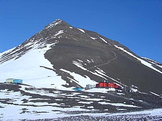
Pearce Dome is a dome shaped mountain rising to about 789 m that is snow and ice free on the north slopes and is situated about 0.5 nautical miles (0.9 km) west-northwest of Khufu Peak and 0.6 nautical miles (1.1 km) due east of Blodwen Peak, situated on the east coast of Alexander Island overlooking George VI Sound and the George VI Ice Shelf, Antarctica. The feature was referred to descriptively as The Snow Dome in scientific reports in the early 1960s, and referred to as Dome by those working in the area. Named for C.J. Pearce, a Falkland Islands Dependencies Survey Meteorologist who spent the first winter season (1961) at Fossil Bluff along with B.J. Taylor and J.P. Smith.
Forsythe Bluff is a bluff rising to more than 2,500 metres (8,200 ft) along the west edge of the Daniels Range, in the Usarp Mountains of Antarctica. The bluff is 11 nautical miles (20 km) north of Big Brother Bluff. It was mapped by the United States Geological Survey from surveys and U.S. Navy air photos, 1960–63, and was named by the Advisory Committee on Antarctic Names after Warren L. Forsythe, a United States Antarctic Research Program geologist at McMurdo Station, 1967–68.
Giza Peak is a peak rising to about 600 metres (2,000 ft) on the east side of the Fossil Bluff massif, eastern Alexander Island, Antarctica. For many years this peak was known to the British Antarctic Survey (BAS) workers as "Sphinx," a name already in use. To avoid duplication, the UK Antarctic Place-Names Committee in 1987 applied the name Giza Peak to this feature in reference to the site of the colossal statue of the Sphinx at El Giza, Egypt.
McArthur Glacier is a glacier between the Christie Peaks and Swine Hill, flowing west from Palmer Land, Antarctica, into George VI Sound. It was named by the UK Antarctic Place-Names Committee for Alistair H. McArthur, a British Antarctic Survey geophysicist at Stonington Island, 1967–68.
Spartan Glacier is a short valley glacier lying between Callisto Cliffs and Tombaugh Cliffs on the east side of Alexander Island, Antarctica. The glacier was first mapped by the Overseas Surveys Directorate from satellite imagery supplied by U.S. National Aeronautics and Space Administration in cooperation with U.S. Geological Survey. Named by United Kingdom Antarctic Place-Names Committee after the British dog team known as "The Spartans," used in ascending this glacier, 1969. This is one of the few glaciers in Antarctica to be named after a dog team.
Khufu Peak is a peak rising to about 745 m located in Planet Heights, near the center of the Fossil Bluff massif, on the east side of Alexander Island, Antarctica, in which the east face of the peak faces towards George VI Sound and the George VI Ice Shelf. For many years this was known to British Antarctic Survey (BAS) workers by the unofficial descriptive name "Pyramid," a name already in use. To avoid duplication, in 1987 the United Kingdom Antarctic Place-Names Committee (UK-APC) applied a new name after Khufu, the second Pharaoh of the Fourth Dynasty of Egypt, who erected the Great Pyramid of El Giza.