
Robben Island is an island in Table Bay, 6.9 kilometres (4.3 mi) west of the coast of Bloubergstrand, north of Cape Town, South Africa. It takes its name from the Dutch word for seals (robben), hence the Dutch/Afrikaans name Robbeneiland, which translates to Seal(s) Island.
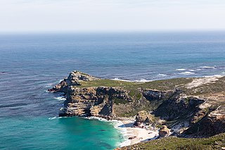
The Cape of Good Hope is a rocky headland on the Atlantic coast of the Cape Peninsula in South Africa.

USS Vincennes was a 703-ton Boston-class sloop of war in the United States Navy from 1826 to 1865. During her service, Vincennes patrolled the Pacific, explored the Antarctic, and blockaded the Confederate Gulf coast in the Civil War. Named for the Revolutionary War Battle of Vincennes, she was the first U.S. warship to circumnavigate the globe.

Weddell Island is one of the Falkland Islands in the South Atlantic, lying off the southwest extremity of West Falkland. It is situated 1,545 km (960 mi) west-northwest of South Georgia Island, 1,165 km (724 mi) north of Livingston Island, 606 km (377 mi) northeast of Cape Horn, 358 km (222 mi) northeast of Isla de los Estados, and 510 km (320 mi) east of the Atlantic entrance to Magellan Strait.

Joinville Island is the largest island of the Joinville Island group, about 40 nautical miles long in an east–west direction and 12 nautical miles wide, lying off the northeastern tip of the Antarctic Peninsula, from which it is separated by the Antarctic Sound.

Maria Island or wukaluwikiwayna in palawa kani is a mountainous island located in the Tasman Sea, off the east coast of Tasmania, Australia. The 115.5-square-kilometre (44.6 sq mi) island is contained within the Maria Island National Park, which includes a marine area of 18.78 square kilometres (7.25 sq mi) off the island's northwest coast. The island is about 20 kilometres (12 mi) in length from north to south and, at its widest, is about 13 kilometres (8.1 mi) west to east. At its closest point, Point Lesueur, the island lies approximately 4 kilometres (2.5 mi) off the east coast of Tasmania.

Saldanha Bay is a natural harbour on the south-western coast of South Africa. The town that developed on the northern shore of the bay, also called Saldanha, was incorporated with five other towns into the Saldanha Bay Local Municipality in 2000. The current population of the municipality is estimated at 72,000.

Algoa Bay is a maritime bay in the Eastern Cape, South Africa. It is located on the east coast, 683 kilometres (424 mi) east of the Cape of Good Hope.
British Peer was a 1428-ton three-masted iron sailing ship built for the British Shipowners Company at the Harland and Wolff yards in Belfast, Ireland, in 1865. She was 247.5 feet (75.4 m) long, 36.4 feet (11.1 m) wide and 22.5 feet (6.9 m) deep. She was bought by the Nourse Line in 1883, and was the fastest vessel in their fleet until British Ambassador was commissioned. In 1878, however, British Peer's sailing power was compromised when alterations were made to increase her tonnage by lengthening her hull by 32 feet (9.8 m), and she was never as fast again. She carried a crew of 23, including her master.
António de Saldanha was a Castilian-Portuguese 16th-century captain. He was the first European to set anchor in what is now called Table Bay, South Africa, and made the first recorded ascent of Table Mountain.

The West Coast National Park lies 88 km (55 mi) north of Cape Town in the Western Cape province of South Africa. The park is found inside of the Cape West Coast Biosphere Reserve, part of the UNESCO Man and the Biosphere Programme. It is bordered by the Atlantic Ocean on the west and the R27 coastal road, and runs from the town of Yzerfontein in the south, up to the Langebaan Lagoon. The park is particularly well known for its bird life and for the spring flowers which occur in the months from August to September, especially in the Postberg flower reserve section of the park. The park, with the islands in Saldanha Bay, has been identified by BirdLife International as an Important Bird Area. The park was proclaimed in 1985, and is 36,259.8 hectares (140.000 sq mi) in size.

Langebaan is a town in the Western Cape province of South Africa on the eastern shore of Langebaan Lagoon.

SAS Somerset was a Bar-class boom defence vessel of the South African Navy, formerly preserved as a museum ship in Cape Town. It was scrapped in April 2024. Formerly HMS Barcross, it operated in Saldanha Bay, was transferred to South Africa Naval Forces during World War II, and was purchased by South Africa in 1947.
The Fifth India Armada was assembled in 1503 on the order of King Manuel I of Portugal and placed under the command of Afonso de Albuquerque. It was Albuquerque's first trip to India. It was not a particularly successful armada - navigational mistakes scattered the fleet on the outward journey. Ships spent much time looking for each other and several ended up travelling alone.

Hopefield is a settlement in West Coast District Municipality in the Western Cape province of South Africa on the R45 between Malmesbury and Vredenburg. The town lies east of Saldanha Bay and Langebaan, 40 km (25 mi) southeast of Vredenburg and 120 km (75 mi) north of Cape Town.
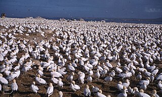
Malgas Island is a small, 8.3 hectares, uninhabited island lying in the northern part of the entrance to Saldanha Bay, in the Western Cape province of South Africa. It lies about 800 metres (2,600 ft) from the mainland in the Benguela upwelling system. It is circular in shape and flat, with the highest point about 9 metres (30 ft) above sea level. It is known for its large breeding colony of Cape gannets.
François Renier Duminy was a French mariner, navigator, cartographer and South African pioneer.
The MT Castillo de Bellver oil spill began on 6 August 1983, when the Spanish tanker caught on fire off Saldanha Bay, approximately 70 miles northwest of Cape Town, South Africa. It was carrying 250,000 tonnes of light crude oil, and was traveling through an environmentally sensitive area known for its seabird rookeries and important commercial fishing grounds. The burning vessel was abandoned and broke apart after drifting offshore. Three crew were lost. The stern capsized and sunk and the bow was sunk using explosives. A total of 145,000-170,000 tonnes of oil entered the sea. Onshore impacts were considered negligible as the slick traveled seaward. The only visible impact was the oiling of 1,500 gannets that were on a nearby island.

Portugal–South Africa relations refer to the current and historical relationship between Portugal and South Africa. Nowadays the two countries have solid relations, with South Africa representing a major partner for Portugal amongst AU members.
The Jutten Island Marine Protected Area is an inshore conservation region in the territorial waters of South Africa in Saldanha Bay, in the Western Cape.


