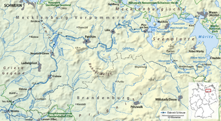
River course
The source area of the Schilde is located in the nature reserve Neuendorfer Moor, which belongs to the district Neuendorf of the municipality Pokrent, about 20 kilometres (12 mi) west of Schwerin. It first turns in a southerly direction and, after about 13 kilometres (8.1 mi), flows through Woezer See in the municipality of Wittendörp. From here, the Schilde flow towards the south-west. In Camin (district of Vellahn), the Motel, the only notable tributary flows into the Schilde. The river flows then into the Schaale near Bennin, a district of Vellahn.
The height difference from the source to the mouth is about 43 metres (141 ft) – from 58 metres (190 ft) to 15 metres (49 ft) above sea level.
At the Schilde, the communities Pokrent, Lützow, Schildetal of district Nordwestmecklenburg and Wittendörp and Vellahn of district Ludwigslust-Parchim are situated.

The Elbe is one of the major rivers of Central Europe. It rises in the Krkonoše Mountains of the northern Czech Republic before traversing much of Bohemia, then Germany and flowing into the North Sea at Cuxhaven, 110 km (68 mi) northwest of Hamburg. Its total length is 1,094 kilometres (680 mi).

The Aller is a 215-kilometre (134 mi) long river in the states of Saxony-Anhalt and Lower Saxony in Germany. It is a right-hand, and hence eastern, tributary of the Weser and is also its largest tributary. Its last 117 kilometres (73 mi) form the Lower Aller federal waterway (Bundeswasserstraße). The Aller was extensively straightened, widened and, in places, dyked, during the 1960s to provide flood control of the river. In a 20-kilometre (12 mi) long section near Gifhorn, the river meanders in its natural river bed.

The Havel is a river in north-eastern Germany, flowing through the German states of Mecklenburg-Vorpommern, Brandenburg, Berlin and Saxony-Anhalt. It is a right tributary of the Elbe and 325 kilometres (202 mi) long. However, the direct distance from its source to its mouth is only 94 kilometres (58 mi).

The Trave is a river in Schleswig-Holstein, Germany. It is approximately 124 kilometres (77 mi) long, running from its source near the village of Gießelrade in Ostholstein to Travemünde, where it flows into the Baltic Sea. It passes through Bad Segeberg, Bad Oldesloe, and Lübeck, where it is linked to the Elbe–Lübeck Canal. It is navigable for sea-going vessels from the Baltic to the Lübeck ports. The Herren Tunnel crosses the Trave, as do numerous bridges, and a ferry connects Travemünde with Priwall. Tributaries of the Trave include the Wakenitz and the Stepenitz.

The Black Elster or Schwarze Elster is a 179-kilometre (111 mi) long river in eastern Germany, in the states Saxony, Brandenburg and Saxony-Anhalt, right tributary of the Elbe. Its source is in the Upper Lusatia region, near Elstra.
The Stecknitz Canal was an artificial waterway in northern Germany which connected Lauenburg and Lübeck on the Old Salt Route by linking the tiny rivers Stecknitz and Delvenau, thus establishing an inland water route across the drainage divide from the North Sea to the Baltic Sea. Built between 1391 and 1398, the Stecknitz Canal was the first European summit-level canal and one of the earliest artificial waterways in Europe. In the 1890s the canal was replaced by an enlarged and straightened waterway called the Elbe–Lübeck Canal, which includes some of the Stecknitz Canal's watercourse.

Lake Schwerin is a lake in Mecklenburg-Vorpommern, northern Germany. It was named after the city Schwerin, on its southwestern shore. The smaller town Bad Kleinen is on the north shore of the lake. Its surface is approximately 61.54 square kilometres (23.76 sq mi), and its maximum depth is 52.4 metres (172 ft). The natural outflow of the lake is the (channelized) river Stör, a tributary of the Elde, and part of the Elbe watershed. The Wallensteingraben, a 16th-century canal, connects the lake with the Baltic Sea at Wismar.

Löcknitz is a river in northern Germany.

The Müritz (help·info) is a lake in Mecklenburg-Vorpommern, northern Germany. Its area is 117 km2 (45 sq mi), which makes it the second largest lake in Germany and the largest lake located entirely within German territory.
The Elde is a river in northern Germany, a right tributary of the Elbe. Its total length is 220 kilometres (140 mi). The Elde originates near Altenhof, south of Malchow. It first flows southeast towards the southern end of Lake Müritz, which it enters at Vipperow. It flows out of the Müritz at its northern end, near Waren. It turns west, and flows through a series of small lakes, and along the town of Malchow, until the Plauer See. It flows out of the Plauer See at Plau am See, and continues west and southwest through Lübz, Parchim, Neustadt-Glewe, Grabow and Eldena, and flows into the Elbe at Dömitz. Near Eldena, the Alte Elde branches off and flows into the Löcknitz near Eldenburg, part of Lenzen (Elbe). For much of its length, 180 kilometres (110 mi), it forms the navigable Müritz-Elde-Wasserstraße, with 17 locks.
Pritzier is a municipality in the Ludwigslust-Parchim district, in Mecklenburg-Vorpommern, Germany. The municipality Pritzier consists of three villages: Pritzier, Pritzier Bahnhof and Schwechow.

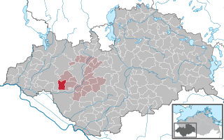
Wittendörp is a municipality in the administrative district of Ludwigslust-Parchim in Mecklenburg-Vorpommern, Germany. The municipality has a seat in the Amt of Wittenburg from where it is administered. The municipality is about 25 kilometres west of Schwerin in the north of the administrative district Ludwigslust-Parchim and borders on the administrative district of Nordwestmecklenburg in the north. The river Schilde flows through the municipality.

Dorf Mecklenburg is a municipality in the Nordwestmecklenburg district, in Mecklenburg-Vorpommern, Germany. It is located 6 km south of Wismar.

The Tarnitz is a tributary of the Löcknitz in southwest Mecklenburg-Vorpommern and north Brandenburg in Germany.
Poland is a country that extends across the North European Plain from the Sudetes and Carpathian Mountains in the south to the sandy beaches of the Baltic Sea in the north. Poland is the fifth-most populous country of the European Union and the ninth-largest country in Europe by area. The territory of Poland covers approximately 312,696 km2 (120,733 sq mi), of which 98.52% is land and 1.48% is water. The Polish coastline was estimated at 770 km (478 mi) in length. Poland's highest point is Mount Rysy, at 2,499 km (1,553 mi).

The Stepenitz is a right-hand tributary of the Trave in the northwest of the German state of Mecklenburg-Vorpommern and within the borough of Lübeck in the state of Schleswig-Holstein.
The Sissle is a 16-kilometre (10 mi) long river in the Swiss canton of Aargau in Switzerland. It is a tributary of the Rhine and drains the eastern part of the Fricktal. The largest town on the river is Frick.
The Ruhn Hills are a terminal moraine ridge up to 176.8 m above sea level (NHN), which lies on either side of the border between the German states of Brandenburg and Mecklenburg-Vorpommern near Parchim. After the Helpt Hills they are the second highest points in the latter federal state.

The Mecklenburg Elbe Valley Nature Park is part of the UNESCO biosphere reserve of Elbe River Landscape, which is over 400 river kilometres long and which runs through the five German states of Saxony-Anhalt, Brandenburg, Lower Saxony, Mecklenburg-Vorpommern and Schleswig-Holstein. It lies in the district of Ludwigslust-Parchim in Mecklenburg-Vorpommern. The nature park was called into existence in 1990 and legally established by act of state in 1998. It has an area of 426 km2 (164 sq mi).
