
Berlin is the capital and largest city of Germany, both by area and by population. Its more than 3.85 million inhabitants make it the European Union's most populous city, as measured by population within city limits. The city is also one of the states of Germany, and is the third smallest state in the country in terms of area. Berlin is surrounded by the state of Brandenburg, and Brandenburg's capital Potsdam is nearby. The urban area of Berlin has a population of over 4.5 million and is therefore the most populous urban area in Germany. The Berlin-Brandenburg capital region has around 6.2 million inhabitants and is Germany's second-largest metropolitan region after the Rhine-Ruhr region, and the sixth-biggest metropolitan region by GDP in the European Union.

The FIFA World Cup, often called the World Cup, is an international association football competition among the senior men's national teams of the members of the Fédération Internationale de Football Association (FIFA), the sport's global governing body. The tournament has been held every four years since the inaugural tournament in 1930, with the exception of 1942 and 1946 due to the Second World War. The reigning champions are Argentina, who won their third title at the 2022 tournament.

Germany, officially the Federal Republic of Germany, is a country in Central Europe. It lies between the Baltic and North Sea to the north and the Alps to the south. Its sixteen constituent states have a total population of over 82 million in an area of 357,569 km2 (138,058 sq mi), making it the most populous member state of the European Union. It borders Denmark to the north, Poland and Czechia to the east, Austria and Switzerland to the south, and France, Luxembourg, Belgium, and the Netherlands to the west. The nation's capital and most populous city is Berlin and its main financial centre is Frankfurt; the largest urban area is the Ruhr.

East Germany, officially known as the German Democratic Republic, was a country in Central Europe from its formation on 7 October 1949 until its reunification with West Germany on 3 October 1990. Until 1989, it was generally viewed as a communist state and described itself as a socialist "workers' and peasants' state". The economy of the country was centrally planned and state-owned. Although the GDR had to pay substantial war reparations to the Soviets, its economy became the most successful in the Eastern Bloc.
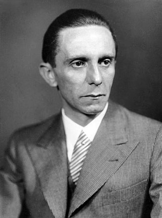
Paul Joseph Goebbels was a German Nazi politician and philologist who was the Gauleiter of Berlin, chief propagandist for the Nazi Party, and then Reich Minister of Propaganda from 1933 to 1945. He was one of Adolf Hitler's closest and most devoted followers, known for his skills in public speaking and his deeply virulent antisemitism which was evident in his publicly voiced views. He advocated progressively harsher discrimination, including the extermination of the Jews in the Holocaust.

Luxembourg, officially the Grand Duchy of Luxembourg, is a small landlocked country in Western Europe. It is bordered by Belgium to the west and north, Germany to the east, and France to the south. Its capital and most populous city, Luxembourg City, is one of the four institutional seats of the European Union and the seat of several EU institutions, notably the Court of Justice of the European Union, the highest judicial authority. Luxembourg's culture, people, and languages are greatly influenced by France and Germany; for example, Luxembourgish, a Germanic language, is the only national language of the Luxembourgish people and of the Grand Duchy of Luxembourg, French is the only language for legislation, and all three – Luxembourgish, German and French – are used for administrative matters in the country.

Nazi Germany, officially known as the German Reich and later the Greater German Reich, was the German state between 1933 and 1945, when Adolf Hitler and the Nazi Party controlled the country, transforming it into a totalitarian dictatorship. The Third Reich, meaning "Third Realm" or "Third Empire", referred to the Nazi claim that Nazi Germany was the successor to the earlier Holy Roman Empire (800–1806) and German Empire (1871–1918). The Third Reich, which the Nazis referred to as the Thousand-Year Reich, ended in May 1945, after only 12 years, when the Allies defeated Germany and entered the capital, Berlin, ending World War II in Europe.

Rammstein is a German Neue Deutsche Härte band formed in Berlin in 1994. The band's lineup—consisting of lead vocalist Till Lindemann, lead guitarist Richard Kruspe, rhythm guitarist Paul Landers, bassist Oliver Riedel, drummer Christoph Schneider, and keyboardist Christian "Flake" Lorenz—has remained unchanged throughout their history, along with their approach to songwriting, which consists of Lindemann writing and singing the lyrics over instrumental pieces the rest of the band has completed beforehand. Prior to their formation, some members were associated with the punk rock acts Feeling B and First Arsch.

Switzerland, officially the Swiss Confederation, is a landlocked country located in west-central Europe. It is bordered by Italy to the south, France to the west, Germany to the north, and Austria and Liechtenstein to the east. Switzerland is geographically divided among the Swiss Plateau, the Alps and the Jura; the Alps occupy the greater part of the territory, whereas most of the country's population of 9 million are concentrated on the plateau, which hosts its largest cities and economic centres, including Zurich, Geneva, and Basel.

The Schutzstaffel was a major paramilitary organisation under Adolf Hitler and the Nazi Party in Nazi Germany, and later throughout German-occupied Europe during World War II.
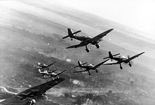
World War II or the Second World War was a global conflict between two coalitions: the Allies and the Axis powers. Nearly all the world's countries—including all the great powers—participated, with many investing all available economic, industrial, and scientific capabilities in pursuit of total war, blurring the distinction between military and civilian resources. Tanks and aircraft played major roles, with the latter enabling the strategic bombing of population centres and delivery of the only two nuclear weapons ever used in war. World War II was the deadliest conflict in history, resulting in 70 to 85 million fatalities, more than half of which were civilians. Millions died in genocides, including the Holocaust of European Jews, and by massacres, starvation, and disease. Following the Allied powers' victory, Germany, Austria, Japan, and Korea were occupied, and war crimes tribunals were conducted against German and Japanese leaders.

Angela Dorothea Merkel is a German retired politician who served as the eighth chancellor of Germany from 2005 to 2021 and was the first woman to hold that office. She previously served as leader of the Opposition from 2002 to 2005 and as the leader of the Christian Democratic Union from 2000 to 2018. During her chancellorship, Merkel was frequently referred to as the de facto leader of the European Union (EU) and the most powerful woman in the world. Beginning in 2016, she was often described as the leader of the free world.

The German Shepherd, also known in Britain as an Alsatian, is a German breed of working dog of medium to large size. The breed was developed by Max von Stephanitz using various traditional German herding dogs from 1899.

The Germany national football team represents Germany in men's international football and played its first match in 1908. The team is governed by the German Football Association, founded in 1900. Between 1949 and 1990, separate German national teams were recognised by FIFA due to Allied occupation and division: the DFB's team representing the Federal Republic of Germany, the Saarland team representing the Saar Protectorate (1950–1956) and the East Germany team representing the German Democratic Republic (1952–1990). The latter two were absorbed along with their records; the present team represents the reunified Federal Republic. The official name and code "Germany FR (FRG)" was shortened to "Germany (GER)" following reunification in 1990.

Heidi Klum is a German-American model, television host, producer, and businesswoman. She appeared on the cover of the Sports Illustrated Swimsuit Issue in 1998 and was the first German model to become a Victoria's Secret Angel.

Inglourious Basterds is a 2009 war film written and directed by Quentin Tarantino, starring Brad Pitt, Christoph Waltz, Michael Fassbender, Eli Roth, Diane Kruger, Daniel Brühl, Til Schweiger and Mélanie Laurent. The film tells an alternate history story of two converging plots to assassinate Nazi Germany's leadership at a Paris cinema—one through a British operation largely carried out by a team of Jewish American soldiers led by First Lieutenant Aldo Raine (Pitt), and another by French Jewish cinema proprietor Shosanna Dreyfus (Laurent) who seeks to avenge her murdered family. Both are faced against Hans Landa (Waltz), an SS colonel with a fearsome reputation for hunting Jews.

Adolf Hitler was an Austrian-born German politician who was the dictator of Nazi Germany from 1933 until his suicide in 1945. He rose to power as the leader of the Nazi Party, becoming the chancellor in 1933 and then taking the title of Führer und Reichskanzler in 1934. His invasion of Poland on 1 September 1939 marked the start of the Second World War. He was closely involved in military operations throughout the war and was central to the perpetration of the Holocaust: the genocide of about six million Jews and millions of other victims.
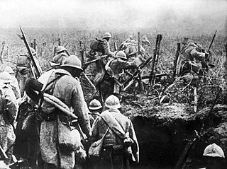
World War I or the First World War, also known as the Great War, was a global conflict between two coalitions: the Allies and the Central Powers. Fighting took place mainly in Europe and the Middle East, as well as in parts of Africa and the Asia-Pacific, and in Europe was characterised by trench warfare and the use of artillery, machine guns, and chemical weapons (gas). World War I was one of the deadliest conflicts in history, resulting in an estimated 9 million military dead and 23 million wounded, plus up to 8 million civilian deaths from causes including genocide. The movement of large numbers of people was a major factor in the Spanish flu pandemic, which killed millions.

Thomas Müller is a German professional footballer who plays for Bundesliga club Bayern Munich. He plays as an attacking midfielder or a second striker. Widely regarded as one of the greatest players in the history of the game, Müller has been praised for his positioning, finishing, playmaking, work-rate, and consistency in both scoring and creating goals.

Dutch is a West Germanic language, spoken by about 25 million people as a first language and 5 million as a second language and is the third most spoken Germanic language. In Europe, Dutch is the native language of most of the population of the Netherlands and Flanders. Dutch was one of the official languages of South Africa until 1925, when it was replaced by Afrikaans, a separate but partially mutually intelligible daughter language of Dutch. Afrikaans, depending on the definition used, may be considered a sister language, spoken, to some degree, by at least 16 million people, mainly in South Africa and Namibia, and evolving from Cape Dutch dialects.


