| Schneeberg | |
|---|---|
| Highest point | |
| Elevation | 692.4 m above sea level (NN) (2,272 ft) |
| Listing | Höchster Berg im Kl. Thür. Wald, südlichster Punkt der Stadt Suhl |
| Coordinates | 50°33′41″N10°39′31″E / 50.5613°N 10.6585°E Coordinates: 50°33′41″N10°39′31″E / 50.5613°N 10.6585°E |
| Geography | |
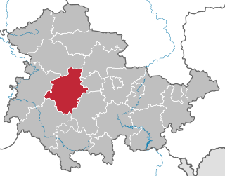
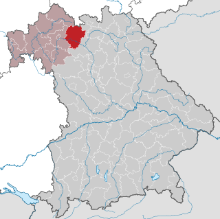
| Location | Thuringia, Germany |
| Parent range | Thuringian Forest |

The Schneeberg is a mountain, 692.4 metres high, that marks the southernmost boundary point of the borough of Suhl in the German state of Thuringia. [1]

Suhl is a city in Thuringia, Germany, located 50 kilometres SW of Erfurt, 110 kilometres NE of Würzburg and 130 kilometres N of Nuremberg. With its 35,000 inhabitants, it is the smallest of the six urban districts within Thuringia. Together with its northern neighbour-town Zella-Mehlis, Suhl forms the largest urban area in the Thuringian Forest with a population of 46,000. The region around Suhl is marked by up to 1,000-meter high mountains, including Thuringia's highest peak, the Großer Beerberg, approximately 5 kilometres NE of the city centre.

Thuringia, officially the Free State of Thuringia, is a state of Germany.
The mountain is forested down to the valley in the south. Its southern mountainside belongs to the parish of Grub and Eichenberg, both small forest villages near Themar in the county of Hildburghausen. The Schneeberg is the highest point of the Little Thuringian Forest. A hiking trail runs over the wooded Schneeberg linking Dolmar to the Rennsteig trail.

Themar is a town in the district of Hildburghausen, in Thuringia, Germany. It is situated on the river Werra, 11 km northwest of Hildburghausen, and 14 km southwest of Suhl.
The Little Thuringian Forest is a region of mountains and hills that lies southwest of Suhl and northwest of Schleusingen, and extends as far as an imaginary line from Schmeheim via Bischofrod and Gethles to Rappelsdorf. Its length is about 11 km (6.8 mi), its width varies between 1 km (0.62 mi) and 2 km (1.2 mi). Its name is not to be understood in an orographic or geographic sense, but is due to the marked similarity of its bedrock to that of the Thuringian Forest to the north of it.
Makita Engineering Germany GmbH (Dolmar) is one of the oldest manufacturers of portable gasoline chainsaws and is headquartered in Hamburg, Germany. The company founder, Emil Lerp, developed in 1927 the "type A" saw, which weighed 125 lb and required two men to operate. It was tested on Mount Dolmar in the Thüringer forest and the company took its name from the test site.