Little Thuringian Forest

Last updated

The Little Thuringian Forest (German : Kleiner Thüringer Wald) [1] is a region of mountains and hills that lies southwest of Suhl and northwest of Schleusingen, and extends as far as an imaginary line from Schmeheim via Bischofrod and Gethles to Rappelsdorf. Its length is about 11 km (6.8 mi), its width varies between 1 km (0.62 mi) and 2 km (1.2 mi). [2] [3] Its name is not to be understood in an orographic or geographic sense, but is due to the marked similarity of its bedrock to that of the Thuringian Forest to the north of it. [4]

German language West Germanic language

German is a West Germanic language that is mainly spoken in Central Europe. It is the most widely spoken and official or co-official language in Germany, Austria, Switzerland, South Tyrol (Italy), the German-speaking Community of Belgium, and Liechtenstein. It is also one of the three official languages of Luxembourg and a co-official language in the Opole Voivodeship in Poland. The languages which are most similar to German are the other members of the West Germanic language branch: Afrikaans, Dutch, English, the Frisian languages, Low German/Low Saxon, Luxembourgish, and Yiddish. There are also strong similarities in vocabulary with Danish, Norwegian and Swedish, although those belong to the North Germanic group. German is the second most widely spoken Germanic language, after English.

Suhl Place in Thuringia, Germany

Suhl is a city in Thuringia, Germany, located 50 kilometres SW of Erfurt, 110 kilometres NE of Würzburg and 130 kilometres N of Nuremberg. With its 37,000 inhabitants, it is the smallest of the six urban districts within Thuringia. Together with its northern neighbour-town Zella-Mehlis, Suhl forms the largest urban area in the Thuringian Forest with a population of 46,000. The region around Suhl is marked by up to 1,000-meter high mountains, including Thuringia's highest peak, the Großer Beerberg, approximately 5 kilometres NE of the city centre.

Schleusingen Place in Thuringia, Germany

Schleusingen is a city in the district of Hildburghausen, in Thuringia, Germany. It is situated 10 km north of Hildburghausen, and 12 km southeast of Suhl.

Contents

Geography

Gethles in the Little Thuringian Forest Gethles.jpg
Gethles in the Little Thuringian Forest
Eichenberg in the Little Thuringian Forest Ansicht von Eichenberg.JPG
Eichenberg in the Little Thuringian Forest

The region extends northwest from Schleusingen, beginning near Rappelsdorf, via Gethles, Ahlstädt, Bischofrod, Keulrod, Eichenberg to north of the Sandberg near Grub, in the northwest of Hildburghausen district, parallel to the Thuringian Forest range. The Little Thuringian Forest is surrounded on all sides by forested mountains formed of Buntsandstein and Muschelkalk, some of which rise over 200 metres above it.

Ahlstädt Place in Thuringia, Germany

Ahlstädt is a municipality in the district of Hildburghausen, in Thuringia, Germany.

Bischofrod Place in Thuringia, Germany

Bischofrod is a municipality in the district of Hildburghausen, in Thuringia, Germany.

Hildburghausen (district) District in Thuringia, Germany

Hildburghausen is a district in Thuringia, Germany. It is bounded by the district of Schmalkalden-Meiningen, the city of Suhl, the districts of Ilm-Kreis, Saalfeld-Rudolstadt and Sonneberg, and the state of Bavaria. Located roughly halfway between the mountain chains of the Rhön and the Thuringian Forest, the district is densely forested and covered by hilly countryside. Its territory is similar to that of the former Ernestine duchy, Saxe-Hildburghausen.

Geology

Geologically, the Little Thuringian Forest is a horst that consists of a band-like island of paleozoic materials similar to those in the bedrock of the Thuringian Forest that surfaces in the southwestern foothills of the latter mountains. Like the latter, it is part of the Variscan mountains, but the stratigraphic throws are lower and have occurred on a smaller scale. It is tectonically isolated from the Thuringian Forest and the Thuringian Highlands, and is situated outside their border fault. Its highest summit is Schneeberg near Bischofrod at 692 m a.s.l., rising from a Buntsandstein layer. While geologically a separate mountain range, it does not appear as such to the casual observer, but as a hilly area with an average height of 460 m a.s.l. embedded between eroded deposits of the Triassic period. Towards the southwest it is limited by a marked border fault. Even the Muschelkalk hills beyond the latter are 30 m (98 ft) to 50 m (160 ft) higher. Several valleys of the foothills of the Thuringian Forest transect the area, showing evidence of a weak folding process. [2] The Little Thuringian Forest is surrounded by Zechstein formations everywhere except along its border fault west of Gethles and Bischofrod. Its northern border is Gruber Berg with an outcrop of Zechstein rock. [3]

Horst (geology) A raised fault block bounded by normal faults

In physical geography and geology, a horst is a raised fault block bounded by normal faults. A horst is a raised block of the Earth's crust that has lifted, or has remained stationary, while the land on either side (graben) has subsided. The word Horst in Dutch and German means heap – cognate with English "hurst".

The PaleozoicEra is the earliest of three geologic eras of the Phanerozoic Eon. It is the longest of the Phanerozoic eras, lasting from 541 to 251.902 million years ago, and is subdivided into six geologic periods : the Cambrian, Ordovician, Silurian, Devonian, Carboniferous, and Permian. The Paleozoic comes after the Neoproterozoic Era of the Proterozoic Eon and is followed by the Mesozoic Era.

Thuringian Forest mountain range in the German state of Thuringia

The Thuringian Forest, is a mountain range in the southern parts of the German state of Thuringia, running northwest to southeast between the valley of the river Werra near Eisenach and the Thuringian-Vogtlandian Slate Mountains. The geographical boundary with the latter range follows approximately a line from Gehren via Großbreitenbach to Schönbrunn near Schleusingen, defined by the rivers Schleuse and Neubrunn on the southwestern slope, and Talwasser, Wohlrose and Möhre on the northeastern slope.

Economy

The area is characterised by farmed fields, since the condition of the soils allows for agricultural productivity, in contrast to the forested Buntsandstein heights. The settlements in the region are thus traditionally farmers' villages. In particular, the Zechstein subsoil around Gethles, Ahlstädt, and Eichenberg yields a good, albeit heavy farming soil. Also, the stratified dolomitic rocks (Plattendolomit) underlie a good farming soil, as does the finely grained lower Buntsandstein with interspersed clay layers. Less suited for cultivation are the upper Buntsandstein soils, and the areas with nutrient-poor porphyric and granitic subsoils are the least cultivable ones. [3]

Iron ore, baryte, and fluorite were mined on Kuhberg hill near Gethles, [3] on Steinberg near Ahlstädt, and between Bischofrod and Eichenberg. Mining, however, was not profitable in the long run due to difficult drainage. The conformation of large deposits of baryte of high quality in the late 1950s did not lead to a revival of mining activities.

Iron ore ore rich in iron or the element Fe

Iron ores are rocks and minerals from which metallic iron can be economically extracted. The ores are usually rich in iron oxides and vary in colour from dark grey, bright yellow, or deep purple to rusty red. The iron is usually found in the form of magnetite (Fe
3
O
4
, 72.4% Fe), hematite (Fe
2
O
3
, 69.9% Fe), goethite (FeO(OH), 62.9% Fe), limonite (FeO(OH)·n(H2O), 55% Fe) or siderite (FeCO3, 48.2% Fe).

Baryte sulfate mineral

Baryte or barite (, ) is a mineral consisting of barium sulfate (BaSO4). Baryte is generally white or colorless, and is the main source of barium. The baryte group consists of baryte, celestine (strontium sulfate), anglesite (lead sulfate), and anhydrite (calcium sulfate). Baryte and celestine form a solid solution (Ba,Sr)SO4.

Fluorite mineral, calcium fluoride

Fluorite (also called fluorspar) is the mineral form of calcium fluoride, CaF2. It belongs to the halide minerals. It crystallizes in isometric cubic habit, although octahedral and more complex isometric forms are not uncommon.

Tourism

There is no protected landscape in the Little Thuringian Forest. An application in the early 1990s was never implemented. Maps and publications implying the contrary do not refer to the geological rock complex described above, but the wooded ridges that rise to the north and northwest of it, including peaks such as the Donnersberg, Schleusinger Berg, Schneeberg , Kesselberg, Galgenberg, Eichenberg , Ehrenberg etc. that are part of the Buntsandstein formation. Hikers following these maps, for example, from Bischofrod or Eichenberg across Schneeberg to the northwest will actually leave the Little Thuringian Forest, as defined in the geological sense.

Protected area location which receives protection because of its recognised natural, ecological or cultural landscape values

Protected areas or conservation areas are locations which receive protection because of their recognized natural, ecological or cultural values. There are several kinds of protected areas, which vary by level of protection depending on the enabling laws of each country or the regulations of the international organizations involved.

Related Research Articles

Franconia Cultural region of Germany

Franconia is a region in Germany, characterised by its culture and language, and may be roughly associated with the areas in which the East Franconian dialect group, colloquially referred to as "Franconian", is spoken. There are several other Franconian dialects, but only the East Franconian ones are colloquially referred to as "Franconian".

Ore Mountains low mountain range in central Europe

The Ore Mountains or Ore Mountain Range in Central Europe have formed a natural border between Saxony and Bohemia for around 800 years, from the 12th to the 20th centuries. Today, the border between Germany and the Czech Republic runs just north of the main crest of the mountain range. The highest peaks are the Klínovec, which rises to 1,244 metres (4,081 ft) above sea level and the Fichtelberg.

Gotha (district) District in Thuringia, Germany

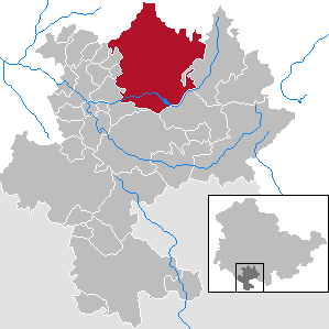
Gotha is a Kreis (district) in western central Thuringia, Germany. Neighboring districts are Unstrut-Hainich-Kreis, Sömmerda, the Kreis-free city Erfurt, Ilm-Kreis, Schmalkalden-Meiningen and the Wartburgkreis.

Schmalkalden-Meiningen District in Thuringia, Germany

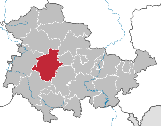
Schmalkalden-Meiningen is a Landkreis in the southwest of Thuringia, Germany. Its neighboring districts are the districts Wartburgkreis, Gotha, Ilm-Kreis, the district-free city Suhl, the district Hildburghausen, the Bavarian district Rhön-Grabfeld, and the district Fulda in Hesse.

Cumberland Mountains mountain range

The Cumberland Mountains are a mountain range in the southeastern section of the Appalachian Mountains. They are located in western Virginia, eastern edges of Kentucky, and eastern middle Tennessee, including the Crab Orchard Mountains. Their highest peak, with an elevation of 4,223 feet (1,287 m) above mean sea level, is High Knob, which is located near Norton, Virginia.

Palatinate Forest low mountain range in Germany

The Palatinate Forest, sometimes also called the Palatine Forest, is a low-mountain region in southwestern Germany, located in the Palatinate in the state of Rhineland-Palatinate. The forest is a designated nature park covering 1,771 km2 and its highest elevation is the Kalmit.

House of Henneberg noble family

Henneberg was a medieval German comital family (Grafen) which from the 11th century onwards held large territories in the Duchy of Franconia. Their county was raised to a princely county in 1310.

Lichte Ortsteil of Neuhaus am Rennweg in Thuringia, Germany

Lichte is a village and a former municipality in the district of Sonneberg in Thuringia, Germany, close to the Thuringian Rennsteig. Formerly in the district Saalfeld-Rudolstadt, it is part of the town Neuhaus am Rennweg since January 2019.

Thuringian Basin

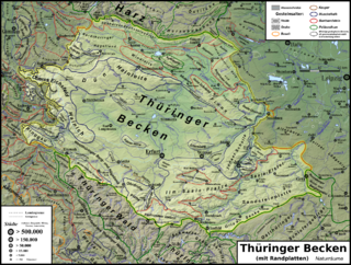
The Thuringian Basin is a depression in the central and northwest part of Thuringia in Germany which is crossed by several rivers, the longest of which is the Unstrut. It stretches about 60 kilometres (37 mi) from north to south and around 120 kilometres (75 mi) from east to west. Its height varies from about 150 to 250 m above sea level (NN).

Thuringian Highland mountain range

The Thuringian HighlandThuringian Highlands or Thuringian-Vogtlandian Slate Mountains is a low range of mountains in the German state of Thuringia.

South German Scarplands natural region of Germany

The South German Scarplands is a geological and geomorphological natural region or landscape in Switzerland and the south German states of Bavaria and Baden-Württemberg. The landscape is characterised by escarpments.

Rennsteig hiking trail in Germany

The Rennsteig is a ridge walk as well as an historical boundary path in the Thuringian Forest, Thuringian Highland and Franconian Forest in Central Germany. The long-distance trail runs for about 170 km from Eisenach and the Werra valley in the northwest to Blankenstein and the Selbitz river in the southeast.

Halle–Hann. Münden railway railway line

The Halle-Halle–Hann. Münden railway is a 218 km long main line operated by the Deutsche Bahn in Germany, which links Halle (Saale) in Saxony-Anhalt with Hann. Münden in the state of Lower Saxony. It is mainly used by regional and east-west goods trains. From 1990 to 1994 it was upgraded as part of a German Unification Transport Project.

Göttingen Forest mountain range in Lower Saxony, Germany

The Göttingen Forest is a ridge in Germany's Central Uplands that is up to 427.5 metres high. It forms part of the Lower Saxon Hills in South Lower Saxony.

Schneeberg (Thuringian Forest)

The Schneeberg is a mountain, 692.4 metres high, that marks the southernmost boundary point of the borough of Suhl in the German state of Thuringia.

Double summit

A double summit, double peak, twin summit or twin peak refers to a mountain or hill that has two summits, separated by a col or saddle.

Geology of Germany

The geology of Germany is heavily influenced by several phases of orogeny in the Paleozoic and the Cenozoic, by sedimentation in shelf seas and epicontinental seas and on plains in the Permian and Mesozoic as well as by the Quaternary glaciations.

Simmersberg mountain in Germany

The Simmersberg is a mountain, 780.8 m above sea level (NHN), near Schnett in the municipality of Masserberg) in the county of Hildburghausen in Germany. It is the main summit of a forked mountain chain, which runs along the boundary between the Thuringian Forest and the Thuringian Highland from Masserberg towards the southwest and is bounded by the valleys of the Schleuse and its tributary, the Biber.

References

  1. Horst Kohl, Joachim Marcinek, Bernhard Nitz (1986). Geography of the German Democratic Republic. Gotha: Haack. ISBN   978-3-7301-0522-1. Translated by D. Hucke and M. Dworatzek
  2. 1 2 Maximilian Tornow (1907). Die Geologie des Kleinen Thüringer Waldes. Schade.
  3. 1 2 3 4 Gerda Schnurr (1963). Die Grundgebirgsscholle des Kleinen Thüringer Waldes und seine bergbauliche Nutzung.
  4. Emmrich and Pröscholdt (1868). Realschulprogramm. Meiningen. p. 3.

Maps