
Indian Hills is a home rule-class city along the Ohio River in Jefferson County, Kentucky, United States. The population was 2,860 as of the 2020 census. Indian Hills and the nearby cities of Mockingbird Valley, Glenview, and Anchorage have been cited as Louisville's most prosperous suburbs since the mid-20th century. Indian Hills was among the nation's highest-income places as of the 2000 U.S. census.

Mockingbird Valley is a home rule-class city in Jefferson County, Kentucky, United States. Since incorporation, there has been some interest in making it a historic preservation district, largely to prevent unwanted development. The population was 167 at the 2010 census. It has the highest per capita income of any location in Kentucky and the tenth-highest of any location in the United States.

Kentucky Kingdom, formerly known as Six Flags Kentucky Kingdom, is an amusement park in Louisville, Kentucky, United States. The 67-acre (27 ha) park includes a collection of amusement rides and the Hurricane Bay water park. Kentucky Kingdom is at the intersection of Interstate 65 and Interstate 264, sharing a parking lot with the Kentucky Exposition Center.

The Louisville Slugger Museum & Factory, is a museum and factory tour attraction located in Louisville, Kentucky's "Museum Row", part of the West Main District of downtown. The museum showcases the story of Louisville Slugger baseball bats in baseball and in American history. The museum also creates temporary exhibits with more of a pop culture focus, including collaborations with the Norman Rockwell Museum, the Charles M. Schulz Museum and Research Center, Coca-Cola, LEGO artists Sean Kenney and Jason Burik, Topps Trading Cards, The Children's Museum of Indianapolis, and Ripley's Believe It or Not!.

Deer Park is a neighborhood four miles southeast of downtown Louisville, Kentucky, USA. Most of the neighborhood was developed from 1890 through the 1920s as a streetcar suburb, with all but six of its 24 subdivisions being developed by 1917, and the last laid out by 1935, although some development west of Norris Place continued after World War II.

Tyler Park is a neighborhood three miles (5 km) southeast of downtown Louisville, Kentucky, USA. It is considered a part of a larger area of Louisville called The Highlands. Near the middle of the neighborhood is a city park of the same name, and many houses in the neighborhood feature park views. The neighborhood boundaries are St Louis Cemetery to the north, Bardstown Road to the east, Eastern Parkway to the south and Beargrass Creek to the west.

The Highlands is an area in Louisville, Kentucky which contains a high density of nightclubs, eclectic businesses, and many upscale and fast food restaurants. It is centered along a three-mile (5 km) stretch of Bardstown Road and Baxter Avenue and is so named because it sits atop a ridge between the middle and south forks of Beargrass Creek. The commercial area extends from the intersection of Bardstown Road and Taylorsville Road/Trevillian Way in the south, to the intersection of Baxter Avenue and Lexington Road in the north, a length of 3.2 miles (5.1 km). A 1⁄2-mile (800 m) section of the nearby Barret Avenue also contains many similar businesses. The residential area is separated from other adjacent areas like Germantown and Crescent Hill by the south and north forks of Beargrass Creek. The middle fork runs through Cherokee Park, and the south fork divides Germantown from Tyler Park, after flowing past several cemeteries and undeveloped forests downstream from Joe Creason Park. Due to its large collection of night clubs and restaurants, it is locally known as "Restaurant Row".

Since it earliest days, the economy of Louisville, Kentucky, has been underpinned by the shipping and cargo industries. Today, Louisville is home to dozens of companies and organizations across several industrial classifications.

The Uptown Theater, known as The Uptown, was a single-screen movie theater in the Cleveland Park neighborhood of Washington, D.C. Opened in 1936, it hosted the world premieres of such movies as 2001: A Space Odyssey and Jurassic Park. It closed in March 2020.

Benjamin Bosworth Smith was an American Protestant Episcopal bishop, and the Presiding Bishop of his Church beginning in 1868.

Mid City Mall is a shopping mall in Louisville, Kentucky's Highlands area. While called a mall, and containing an enclosed shopping area, it has features atypical of suburban American malls, such as a comedy club, bar, grocery store and public library. A 1994 article in Louisville's Courier-Journal newspaper argued that the mall could be considered the "crossroads" of Louisville, and described it as being "only part shopping center, because it is also community center, courthouse square and retirement-village rec room."
Owsley Brown Frazier was a philanthropist from Louisville, Kentucky United States who founded the Frazier History Museum. He retired from the board of directors of the Brown-Forman corporation, which his grandfather George Garvin Brown founded in 1870, and is one of the largest American-owned companies in the spirits and wine business. He was raised in Louisville.

The Willam R. Belknap School is a former school building in the Belknap neighborhood of Louisville, Kentucky United States. It was added to the National Register of Historic Places in 1982. It was designated as a local landmark by the Louisville Metro Landmarks Commission in 2001.

The parkway system of Louisville, Kentucky, also known as the Olmsted Park System, was designed by the firm of preeminent 19th century landscape architect Frederick Law Olmsted. The 26-mile (42 km) system was built from the early 1890s through the 1930s, and initially owned by a state-level parks commission, which passed control to the city of Louisville in 1942.
Bardstown Road is a major road in Louisville, Kentucky. It is known as "Restaurant Row", which comes from Bardstown Road's many restaurants, bakeries, and cafes, such as: "SuperChefs ", "Ramsi's Cafe on the World ", "Mark's Feed Store ", "Kizito Cookies ", and "Louisville Joe's Coffee Company ". It carries U.S. Route 31E and U.S. Route 150, from the intersection of Baxter Avenue (US 31E) and Broadway (US 150), southeast through Jefferson and Bullitt counties; in Spencer and Nelson counties, the road is named Louisville Road; that road becomes 3rd Street in Bardstown, where US 31E and US 150 split at the intersection with U.S. Route 62.

The Cherokee Triangle is a historic neighborhood in Louisville, Kentucky, USA, known for its large homes displaying an eclectic mix of architectural styles. Its boundaries are Bardstown Road to the southwest, Cherokee Park and Eastern Parkway to the southeast, and Cave Hill Cemetery to the north, and is considered a part of a larger area of Louisville called The Highlands. It is named for nearby Cherokee Park, a 409 acres (1.7 km2) park designed by Frederick Law Olmsted, the designer of New York's Central Park.
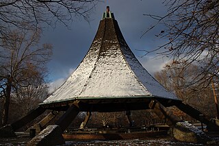
The Hogan's Fountain Pavilion was a large gazebo and picnic shelter of mid-century modern architecture built in 1965 and located in Cherokee Park, Louisville, Kentucky, United States. It was considered the most prominent landmark in Cherokee Park until it was demolished in 2023.
The Louisville Zombie Attack, which started on August 29, 2005, as a flash mob, is a public event in Louisville, Kentucky held annually in August. Before 2016, it had been held on August 29 at 8:29 p.m., but the 2016 event was moved to August 27 at the same time and rebranded as the "Louisville Zombie Walk". This resulted in a lawsuit between two of the event's co-founders, John King and Lyndi Curtis, which resulted in Curtis abandoning all rights to the event. The Louisville Zombie Walk's co-organizer, Jason Bessemann, was not named in the suit and went on to promote the 2017 Louisville Zombie Walk as a separate event three days before the original. Several thousand participants dressed and made up as zombies gather in the Highlands area and march down Bardstown Road to the end point of the walk. An after party is typically thrown by all the bars included in the nightlife throughout the street after the walk. Some of the bars included are: Nowhere Bar, Highlands Taproom, Big Bar, Baxter's, and many others in the local area. Throughout the years, the walk grew by thousands as word of mouth caught on. The last few years, the walk has generated over 10,000 walkers, with 30,000 in 2013 and 32,000 in 2014. Over 40,000 walkers were anticipated for the 2015 event. It began as a birthday party for three friends, but has turned into a real event recognized by local businesses. The event typically costs around $10,000 to function, but the event is kept free to the public due to donations.


