Schwarzhofen

Last updated
Schwarzhofen
DEU Schwarzhofen COA.svg
Location of Schwarzhofen within Schwandorf district
Schwarzhofen in SAD.svgAltendorfSchwarzachWeidingWolferlohe
Germany adm location map.svg
Red pog.svg
Schwarzhofen
Bavaria location map.svg
Red pog.svg
Schwarzhofen
Coordinates: 49°23′N12°21′E / 49.383°N 12.350°E / 49.383; 12.350
Country Germany
State Bavaria
Admin. region Oberpfalz
District Schwandorf
Municipal assoc. Neunburg vorm Wald
Government
   Mayor (202026) Maximilian Beer [1] (CSU)
Area
  Total
36.11 km2 (13.94 sq mi)
Elevation
382 m (1,253 ft)
Population
 (2023-12-31) [2]
  Total
1,409
  Density39/km2 (100/sq mi)
Time zone UTC+01:00 (CET)
  Summer (DST) UTC+02:00 (CEST)
Postal codes
92447
Dialling codes 09672
Vehicle registration SAD
Website www.schwarzhofen.de

Schwarzhofen is a municipality in the district of Schwandorf in Bavaria, Germany.

Contents

Climate

Schwarzhofen
Climate chart (explanation)
J
F
M
A
M
J
J
A
S
O
N
D
 
 
107
 
 
−4
−8
 
 
60
 
 
−2
−7
 
 
31
 
 
7
−1
 
 
56
 
 
16
4
 
 
124
 
 
19
9
 
 
106
 
 
24
12
 
 
96
 
 
23
14
 
 
119
 
 
22
12
 
 
85
 
 
20
8
 
 
84
 
 
12
6
 
 
74
 
 
3
−2
 
 
95
 
 
−3
−7
Average max. and min. temperatures in °C
Precipitation totals in mm
Source: [3]
Imperial conversion
JFMAMJJASOND
 
 
4.2
 
 
25
18
 
 
2.4
 
 
28
19
 
 
1.2
 
 
45
30
 
 
2.2
 
 
61
39
 
 
4.9
 
 
66
48
 
 
4.2
 
 
75
54
 
 
3.8
 
 
73
57
 
 
4.7
 
 
72
54
 
 
3.3
 
 
68
46
 
 
3.3
 
 
54
43
 
 
2.9
 
 
37
28
 
 
3.7
 
 
27
19
Average max. and min. temperatures in °F
Precipitation totals in inches

Neighbouring communities

The neighbouring communities clockwise: Niedermurach, Dieterskirchen, Neunburg vorm Wald, Altendorf.

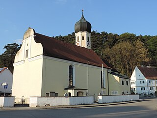
Schwarzhofen (2011) Schwarzhofen 2011 01.jpg
Schwarzhofen (2011)
Market-Place Schwarzhofen Bild Schwarzhofen 2011 01.JPG
Market-Place Schwarzhofen

Related Research Articles

<span class="mw-page-title-main">Baar, Bavaria</span> Municipality in Bavaria, Germany

Baar is a municipality in Aichach-Friedberg district, in Bavaria, southern Germany.

<span class="mw-page-title-main">Brunn, Upper Palatinate</span> Municipality in Bavaria, Germany

Brunn is a municipality in the Upper Palatinate (Oberpfalz) in the administrative district Landkreis Regensburg.

<span class="mw-page-title-main">Bruckmühl</span> Municipality in Bavaria, Germany

Bruckmühl is a market town in the district of Rosenheim, in Bavaria, Germany. It is situated on the river Mangfall, 16 km west of Rosenheim.

<span class="mw-page-title-main">Thannhausen</span> Town in Bavaria, Germany

Thannhausen is a town in the district of Günzburg, in Bavaria, Germany. It is situated on the river Mindel, 24 kilometres (15 mi) southeast of Günzburg, and 33 kilometres (21 mi) west of Augsburg.

<span class="mw-page-title-main">Eggolsheim</span> Municipality in Bavaria, Germany

Eggolsheim is a municipality in the district of Forchheim in Bavaria in Germany.

<span class="mw-page-title-main">Wörnitz</span> Municipality in Bavaria, Germany

Wörnitz is a municipality in the district of Ansbach, in Bavaria, Germany. It is situated on the river Wörnitz, west of Ansbach.

<span class="mw-page-title-main">Adelshofen, Middle Franconia</span> Municipality in Bavaria, Germany

Adelshofen is a municipality in the district of Ansbach in Bavaria in Germany.
<span class="mw-page-title-main">Dürrwangen</span> Municipality in Bavaria, Germany

Dürrwangen is a municipality in the district of Ansbach in Bavaria in Germany.

<span class="mw-page-title-main">Flachslanden</span> Municipality in Bavaria, Germany

Flachslanden is a municipality in the district of Ansbach in Bavaria in Germany.

<span class="mw-page-title-main">Mönchsroth</span> Municipality in Bavaria, Germany

Mönchsroth is a municipality in the district of Ansbach in Bavaria in Germany.

<span class="mw-page-title-main">Ohrenbach</span> Municipality in Bavaria, Germany

Ohrenbach is a municipality in the district of Ansbach in Bavaria in Germany.

<span class="mw-page-title-main">Bischofswiesen</span> Municipality in Bavaria, Germany

Bischofswiesen is a municipality in the district of Berchtesgadener Land in Bavaria in Germany.

<span class="mw-page-title-main">Leuchtenberg</span> Municipality in Bavaria, Germany

Leuchtenberg is a municipality in the district of Neustadt an der Waldnaab in Bavaria, Germany, essentially a suburb of nearby Weiden in der Oberpfalz, and a larger historical region in the Holy Roman Empire governed by the Landgraves of Leuchtenberg.

<span class="mw-page-title-main">Roßhaupten</span> Municipality in Bavaria, Germany

Roßhaupten is a municipality in the district of Ostallgäu in Bavaria in Germany.

<span class="mw-page-title-main">Beratzhausen</span> Municipality in Bavaria, Germany

Beratzhausen is a market town and municipality in the district of Regensburg in Bavaria in Germany.

<span class="mw-page-title-main">Hohenroth</span> Municipality in Bavaria, Germany

Hohenroth is a municipality in the district of Rhön-Grabfeld in Bavaria in Germany.

<span class="mw-page-title-main">Schwarzenfeld</span> Municipality in Bavaria, Germany

Schwarzenfeld is a municipality in the district of Schwandorf in Bavaria, Germany. Schwarzenfeld was first mentioned as “Suarzinvelt” on April 17, 1015 in a deed of gift from Emperor Henry II to the diocese of Bamberg. In 1890 Schwarzenfeld was elevated to market status.
<span class="mw-page-title-main">Dieterskirchen</span> Municipality in Bavaria, Germany

Dieterskirchen is a municipality in the district of Schwandorf in Bavaria, Germany.

<span class="mw-page-title-main">Buxheim, Swabia</span> Municipality in Bavaria, Germany

Buxheim is a municipality in the district of Unterallgäu in Bavaria, Germany.

<span class="mw-page-title-main">Kist, Bavaria</span> Municipality in Bavaria, Germany

Kist is a municipality in the district of Würzburg in Bavaria in Germany.

References

  1. Liste der ersten Bürgermeister/Oberbürgermeister in kreisangehörigen Gemeinden, Bayerisches Landesamt für Statistik, 15 July 2021.
  2. Genesis Online-Datenbank des Bayerischen Landesamtes für Statistik Tabelle 12411-003r Fortschreibung des Bevölkerungsstandes: Gemeinden, Stichtag (Einwohnerzahlen auf Grundlage des Zensus 2011).
  3. "NASA Earth Observations Data Set Index". NASA. Retrieved 30 January 2016.