Schwielochsee

Last updated
Schwielochsee
Location of Schwielochsee within Dahme-Spreewald district
Schwielochsee in LDS.pngHalbeLübbenSchönwaldSchwerin
Germany adm location map.svg
Red pog.svg
Schwielochsee
Brandenburg location map.svg
Red pog.svg
Schwielochsee
Coordinates: 51°59′08″N14°13′09″E / 51.985514°N 14.219055°E / 51.985514; 14.219055
Country Germany
State Brandenburg
District Dahme-Spreewald
Municipal assoc. Lieberose/Oberspreewald
Government
   Mayor (202429) Rainer Hilgenfeld [1]
Area
  Total130.83 km2 (50.51 sq mi)
Highest elevation
103 m (338 ft)
Lowest elevation
41 m (135 ft)
Population
 (2022-12-31) [2]
  Total1,501
  Density11/km2 (30/sq mi)
Time zone UTC+01:00 (CET)
  Summer (DST) UTC+02:00 (CEST)
Postal codes
15848, 15913
Dialling codes 033676, 033671, 035478, 035751
Vehicle registration LDS
Website Gemeinde Schwielochsee

Schwielochsee is a municipality in the district of Dahme-Spreewald in Brandenburg in Germany formed of 10 small villages. It is located at the southern shores of the lake Schwielochsee.

Contents

History

On 26 October 2003, the municipality of Schwielochsee was formed by merging six municipalities. These were Goyatz-Guhlen, Jessern, Lamsfeld-Groß Liebitz, Mochow, Ressen-Zaue and Speichrow.

From 1815 to 1947, the constituent localities of Schwielochsee were part of the Prussian Province of Brandenburg, from 1947 to 1952 of the State of Brandenburg, from 1952 to 1990 partially (Goyatz-Guhlen, Jessern, Lamsfeld-Groß Liebitz, Mochow and Ressen-Zaue) of the Bezirk Cottbus and partially (Speichrow) of the Bezirk Frankfurt of East Germany. Since 1990, they have again been part of Brandenburg, since 2003 united as the municipality of Schwielochsee.

Demography

Development of population since 1875 within the current boundaries (Blue line: Population; Dotted line: Comparison to population development of Brandenburg state; Grey background: Time of Nazi rule; Red background: Time of communist rule) Bevolkerungsentwicklung Schwielochsee.pdf
Development of population since 1875 within the current boundaries (Blue line: Population; Dotted line: Comparison to population development of Brandenburg state; Grey background: Time of Nazi rule; Red background: Time of communist rule)
Schwielochsee: Population development
within the current boundaries (2017) [3]
YearPop.±% p.a.
1875 2,517    
1890 2,327−0.52%
1910 1,985−0.79%
1925 1,950−0.12%
1933 1,928−0.14%
1939 1,929+0.01%
1946 2,790+5.41%
1950 2,538−2.34%
1964 1,785−2.48%
1971 1,698−0.71%
1981 1,509−1.17%
1985 1,491−0.30%
1989 1,501+0.17%
1990 1,500−0.07%
YearPop.±% p.a.
1991 1,506+0.40%
1992 1,548+2.79%
1993 1,523−1.61%
1994 1,522−0.07%
1995 1,549+1.77%
1996 1,572+1.48%
1997 1,588+1.02%
1998 1,643+3.46%
1999 1,700+3.47%
2000 1,706+0.35%
2001 1,741+2.05%
2002 1,734−0.40%
2003 1,699−2.02%
2004 1,693−0.35%
YearPop.±% p.a.
2005 1,702+0.53%
2006 1,668−2.00%
2007 1,666−0.12%
2008 1,633−1.98%
2009 1,628−0.31%
2010 1,613−0.92%
2011 1,600−0.81%
2012 1,561−2.44%
2013 1,556−0.32%
2014 1,523−2.12%
2015 1,499−1.58%
2016 1,490−0.60%
2017 1,488−0.13%

Related Research Articles

<span class="mw-page-title-main">Spree (river)</span> River in Germany and the Czech Republic

The Spree or Sprjewja is, with a length of approximately 400 kilometres (250 mi), the main tributary of the River Havel. The Spree is much longer than the Havel, which it flows into at Berlin-Spandau; the Havel then flows into the Elbe at Havelberg. The river rises in the Lusatian Highlands, that are part of the Sudetes, in the Lusatian part of Saxony, where it has three sources: the historical one called Spreeborn in the village of Spreedorf, the water-richest one in Neugersdorf, and the highest elevated one in Eibau. The Spree then flows northwards through Upper and Lower Lusatia, where it crosses the border between Saxony and Brandenburg. After passing through Cottbus, it forms the Spree Forest, a large inland delta and Biosphere reserve. It then flows through Lake Schwielochsee before entering Berlin, as Müggelspree(pronounced[ˈmʏɡl̩ˌʃpʁeː] ).

Dahme-Spreewald is a district in Brandenburg, Germany. It is bounded by the districts of Oder-Spree, Spree-Neiße, Oberspreewald-Lausitz, Elbe-Elster and Teltow-Fläming, and by the city of Berlin.

<span class="mw-page-title-main">Lübbenau</span> Town in Brandenburg, Germany

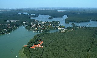
Lübbenau is a town in the Upper Spree Forest-Lusatia District of Brandenburg, Germany. It is located in the bilingual German/Sorbian region of (Lower) Lusatia, on the river Spree, where this forms a large inland delta surrounded by woodland, called "Spree Forest", about 82 km (51 mi) southeast of Berlin. The town is best known through the incorporated villages of Lehde/Lědy and Leipe/Lipje, villages where there just exist anabranches of the Spree River instead of streets.

<span class="mw-page-title-main">Dahme, Brandenburg</span> Town in Brandenburg, Germany

Dahme is a town in the Teltow-Fläming district of Brandenburg, Germany. It is situated on the Dahme River, 30 km southeast of Luckenwalde, and 38 km west of Lübbenau.

<span class="mw-page-title-main">Storkow, Brandenburg</span> Town in Brandenburg, Germany

Storkow (Mark) is a town in Oder-Spree district, in Brandenburg, Germany. The town was the part of Brandenberg Province of Prussia, from 1815 - 1947, then it was the part of the State of Brandenburg from 1947 to 1952, Bezirk Frankfurt of East Germany from 1952 to 1990 and it again became a part of the State of Brandenburg since 1990.

<span class="mw-page-title-main">Lieberose</span> Town in Brandenburg, Germany

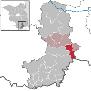
Lieberose is a town in the Dahme-Spreewald district, in Brandenburg, Germany. It is situated 25 km north of Cottbus.

<span class="mw-page-title-main">Vetschau</span> Town in Brandenburg, Germany

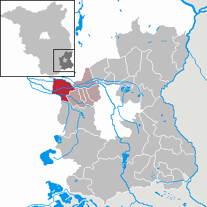
Vetschau/Spreewald is a town in the Oberspreewald-Lausitz district, in Lower Lusatia, Brandenburg, Germany. It is situated in the Spreewald, 18 km west of Cottbus.

<span class="mw-page-title-main">Schorfheide, Brandenburg</span> Municipality in Brandenburg, Germany

Schorfheide is a municipality in the Barnim district of Brandenburg, Germany. It was established in 2003 by the merger of Finowfurt and Groß Schönebeck.

<span class="mw-page-title-main">Ziethen, Brandenburg</span> Municipality in Brandenburg, Germany

Ziethen is a municipality in the district of Barnim in Brandenburg in Germany.

<span class="mw-page-title-main">Heidesee</span> Municipality in Brandenburg, Germany

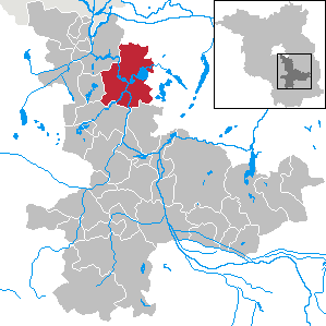
Heidesee is a municipality in the district of Dahme-Spreewald in Brandenburg, which is located in the eastern part of Germany.

<span class="mw-page-title-main">Märkische Heide</span> Municipality in Brandenburg, Germany

Märkische Heide is a municipality in the district of Dahme-Spreewald in Brandenburg in Germany.

<span class="mw-page-title-main">Groß Köris</span> Municipality in Brandenburg, Germany

Groß Köris is a municipality in the district of Dahme-Spreewald in Brandenburg in Germany.

<span class="mw-page-title-main">Jamlitz</span> Municipality in Brandenburg, Germany

Jamlitz is a municipality in the district of Dahme-Spreewald in Brandenburg in Germany.

<span class="mw-page-title-main">Krausnick-Groß Wasserburg</span> Municipality in Brandenburg, Germany

Krausnick-Groß Wasserburg is a municipality in the district of Dahme-Spreewald in Brandenburg in Germany. Tropical Islands Resort, the biggest free-standing hall in the world, is located in Krausnick.

<span class="mw-page-title-main">Zeuthen</span> Municipality in Brandenburg, Germany

Zeuthen is a municipality in the district of Dahme-Spreewald in Brandenburg in Germany.

<span class="mw-page-title-main">Neu-Seeland</span> Municipality in Brandenburg, Germany

Neu-Seeland is a municipality in the Oberspreewald-Lausitz district, in Lower Lusatia, Brandenburg, Germany.

<span class="mw-page-title-main">Burg (Spreewald)</span> Municipality in Brandenburg, Germany

Burg (Spreewald) (Lower Sorbian: Bórkowy (Błota)) is a municipality in the district of Spree-Neiße, in Lower Lusatia, Brandenburg, Germany.

<span class="mw-page-title-main">Hohenselchow-Groß Pinnow</span> Municipality in Brandenburg, Germany

Hohenselchow-Groß Pinnow is a municipality in the Uckermark district, in Brandenburg, Germany.

<span class="mw-page-title-main">Schmöckwitz</span> Quarter of Berlin in Germany

Schmöckwitz is a German locality (Ortsteil) within the Berlin borough (Bezirk) of Treptow-Köpenick. Until 2001 it was part of the former borough of Köpenick.

<span class="mw-page-title-main">Grünau (Berlin)</span> Quarter of Berlin in Germany

Grünau is a German locality (Ortsteil) within the Berlin borough (Bezirk) of Treptow-Köpenick. Until 2001 it was part of the former borough of Köpenick.

References

  1. Landkreis Dahme-Spreewald Wahl der Bürgermeisterin / des Bürgermeisters. Retrieved 27 June 2024.
  2. "Bevölkerungsentwicklung und Bevölkerungsstandim Land Brandenburg Dezember 2022" (PDF). Amt für Statistik Berlin-Brandenburg (in German). June 2023.
  3. Detailed data sources are to be found in the Wikimedia Commons.Population Projection Brandenburg at Wikimedia Commons