Schwinge (Elbe)

Last updated
Schwinge
Schwinge Unterlauf im Fruhling.jpg
Lower reach of the Schwinge in Spring
Location
Country Germany
State Lower Saxony
Physical characteristics
Source 
  locationIn the Hohes Moor near Mulsum  [ de; nds; nl ] (part of Kutenholz)
  elevation9 m (30 ft)
Mouth  
  location
Stadersand
  coordinates
53°37′45″N9°31′37″E / 53.6293°N 9.5269°E / 53.6293; 9.5269 Coordinates: 53°37′45″N9°31′37″E / 53.6293°N 9.5269°E / 53.6293; 9.5269
  elevation
0 m (0 ft)
Length31.8 km (19.8 mi) [1]
Basin size214 km2 (83 sq mi) [1]
Basin features
Progression ElbeNorth Sea
Tributaries 
  leftGrenzgraben, Kattenbeck, Harschenflether Wettern
  rightKühlhornsbach, Beverbeck, Fredenbecker Mühlenbach, Westernbeck, Steinbeck, Heidbeck, Hollerner Moorwettern

The Schwinge is a river of Lower Saxony, Germany, a left tributary of the Elbe.

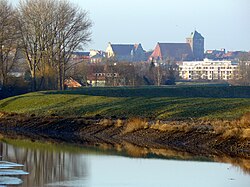
The Schwinge is 31.8 kilometres (19.8 mi) long. It rises in the Hohes Moor near Mulsum  [ de; nds; nl ] (a part of Kutenholz) on the Stade Geest in the bifurcation area with the Oste. From there it flows in a largely natural, more than 20-kilometre-long (12 mi) upper reach towards Stade. Because of its very natural river scenery and its biodiversity, the floodplains of the upper reach and the meadows near Stade are protected for landscape conservation.

In Stade the ca. 1000-year-old Hanse port ( Alter Hansehafen Stade  [ de ]) lies at the Schwinge. Here the upper reach is isolated from tides by a sluice called Salztorschleuse since 1792; the lower reach of the Schwinge, which flows into the lower Elbe north-eastern of Stade at Stadersand, begins. Because of the deepening of the Elbe the average tidal hub of the lower reach rose to 3.3 metres (11 ft), because of the backlog when the sluice gates are closed the fluctuations of the upper reach only amounts to a few decimeters. Despite the embankment the banks of the lower reach are lined with exceptional rare fresh water mudflats.

The Schwinge is a 4.6-kilometre-long (2.9 mi) federal waterway from the Elbe to the Salztorschleuse. Since the completion of the Schwingesperrwerk, a flood barrier near the mouth of the river in 1971, all places at the Schwinge are protected better against storm surges. The 16-metre-wide (52 ft) gap is closed with two gates.

From the Late Middle Ages until the 1950s the Schwinge was used for the transport of goods with smack-like ships called "Ewer  [ da; de; nds ]". During dredging of the Schwinge and the Hansehafen countless historic artefacts were found, including famous Ulfberht swords from the 8th to 12th century. Today, however, the leisure and sports boat traffic dominates the shipping on the lower reach, the upper reach beyond Stade isn't navigable.

ItDozent Schwingewiesen 001.jpg
The meadows of the Schwinge near Stade during a flood. View towards the Schwarzer Berg (Stade)  [ de; nds ], a geest height.

See also

Related Research Articles

Elbe Major river in Central Europe

The Elbe is one of the major rivers of Central Europe. It rises in the Giant Mountains of the northern Czech Republic before traversing much of Bohemia, then Germany and flowing into the North Sea at Cuxhaven, 110 kilometres northwest of Hamburg. Its total length is 1,094 km (680 mi).

Aller (Germany) River in Germany

The Aller is a 215-kilometre-long (134 mi) river in the states of Saxony-Anhalt and Lower Saxony in Germany. It is a right-hand, and hence eastern, tributary of the Weser and is also its largest tributary. Its last 117 kilometres (73 mi) form the Lower Aller federal waterway (Bundeswasserstraße). The Aller was extensively straightened, widened and, in places, dyked, during the 1960s to provide flood control of the river. In a 20-kilometre-long (12 mi) section near Gifhorn, the river meanders in its natural river bed.

Havel River in Germany

The Havel is a river in northeastern Germany, flowing through the states of Mecklenburg-Vorpommern, Brandenburg, Berlin and Saxony-Anhalt. It is a right tributary of the Elbe and 325 kilometres (202 mi) long. However, the direct distance from its source to its mouth is only 94 kilometres (58 mi). For much of its length, the Havel is navigable; it provides an important link in the waterway connections between the east and west of Germany, as well as beyond.

Saale River in Germany

The Saale, also known as the Saxon Saale and Thuringian Saale, is a river in Germany and a left-bank tributary of the Elbe. It is not to be confused with the smaller Franconian Saale, a right-bank tributary of the Main, or the Saale in Lower Saxony, a tributary of the Leine.

Bad Schandau Town in Saxony, Germany

Bad Schandau is a spa town in Germany, in the Sächsische Schweiz-Osterzgebirge district of the Free State of Saxony. It is situated on the right bank of the Elbe, at the mouth of the valley of the Kirnitzsch and in the area often described as Saxon Switzerland.

Oste River in Lower Saxony, Germany

Oste is a river in northern Lower Saxony, Germany with a length of 156 km (97 mi). It is a left tributary of the Elbe.

Black Elster River in Germany

The Black Elster or Schwarze Elster is a 179-kilometre (111 mi) long river in eastern Germany, in the states Saxony, Brandenburg and Saxony-Anhalt, right tributary of the Elbe. Its source is in the Upper Lusatia region, near Elstra.

Aue (Elbe) River in Germany

The Aue is a river in northern Germany in the district of Stade in Lower Saxony. It has a length of about 30 km (19 mi).

Ise (river) River in Germany

The Ise is a 43 km (27 mi) long, almost natural river of East Lower Saxony and Saxony-Anhalt, Germany. It crosses the district of Gifhorn from north to south and discharges into the Aller at Gifhorn itself.

Geeste (river) River in Germany

The Geeste is a river in northwestern Germany, running through Lower Saxony and Bremen. It is the most downstream tributary of the River Weser and joins it near Bremerhaven. The Geeste rises in Hipstedt in the district of Rotenburg (Wümme) ten kilometres west of Bremervörde and drains a large part of the old district of Wesermünde.

Elbe–Weser waterway

The Elbe–Weser waterway or Elbe–Weser shipping channel is a short-cut between the rivers Elbe and Weser in North Germany which is part-canal and part-river. It has a length of 54.7 kilometres (34.0 mi) and is designed for smaller coastal vessels. It includes some 60 kilometres (37 mi) of canal dykes and 45 kilometres (28 mi) of canal paths. The channel starts in Otterndorf with the Hadeln Canal, then becomes the Bederkesa-Geeste Canal from the town of Bad Bederkesa to the River Geeste, the final leg of the shipping channel, which flows into the Weser at Bremerhaven. It is owned by the state of Lower Saxony, maintained by the NLWKN from its Stade office. Today they just look after maintenance of the drainage system, because the economic element of the canal – commercial shipping which was particularly thriving in the late 1960s – declined increasingly from 1973 onwards and today hardly exists at all. Nevertheless the waterway is still used by smaller yachts as a short cut between Elbe and Weser.

Abelitz (river) River in Germany

The Abelitz is a river of Lower Saxony, Germany, in East Frisia. It is about 20 kilometres (12 mi) long and flows from Marienhafe to its mouth on the Alte Greetsieler Sieltief. This type of river that drains the low-lying polders through a sluice in the sea dyke is also known locally as a Tief and is often the course of an old creek between mudflats.

Lühe (river) River in Germany

Lühe is a river in northern Germany in the district of Stade in Lower Saxony, Germany.

Black Pockau River in Germany

The Black Pockau is a river of Saxony, Germany, in the Ore Mountains. It is a left tributary of the Flöha. This virtually unspoilt wild stream with a length of 33 km (21 mi) is known for the picturesque gorge in its middle reaches.

Sebnitz (river) River in Germany

The Sebnitz is the left, larger headstream of the Lachsbach and runs through both the Czech Republic as well as the German Free State of Saxony. The upper section in the Czech Republic is known as Vilémovský potok in Czech and Wölmsdorfer Bach in German.

Lake Cachí Body of water

Lake Cachi is an artificial lake in central Costa Rica created by the Cachí Dam, an arch dam north of Tapantí National Park, to the east-southeast of Cartago in Cartago Province. The main town is Cachí, away from the east bank of the lake. Built in the 1970s, it was one of the first hydroelectric projects in Costa Rica. It has an installed capacity of 102 MW with three units of 34 MW capacity each.

Niederelbe River in Germany

The Niederelbe is a 108 kilometers long section of the river Elbe, from western Hamburg downstream to its mouth into the North Sea near Cuxhaven. Starting at Mühlenberger Loch near Finkenwerder, Hamburg, it gradually widens from 2 km (1.2 mi) to 18 km (11 mi). Once passing the Hamburg state border, the Niederelbe also forms the border between the states of Lower Saxony and Schleswig-Holstein.

Unterelbe River in Germany

The Unterelbe or, in English usually the Lower Elbe, refers to the lower reaches of the river Elbe in Germany influenced by the tides.

Schwingesperrwerk Movable barrier on the Elbe River in Germany

The Schwingesperrwerk is a man-made movable barrier located on the Schwinge at its confluence with the Elbe near Stade, Germany. It is part of the flood control program for the Lower Elbe tidewater region, from the weir in Geesthacht to the mouth of the Elbe where it flows into the North Sea. Engineers constructed the Schwingesperrwerk after a storm surge caused severe floods in the region in 1962.

Upper Noteć Canals Waterway, canals, 1882, Kuyavian-Pomeranian Voivodeship, Poland

The Upper Noteć Canals are an aggregate of inland water channels in Kuyavian-Pomeranian Voivodeship, Poland. They stem from the upper part of the Noteć river, north of Gopło lake, and mouth at their northern point into the Bydgoszcz Canal, west of the city territory. These canals have been put into operation between the 1770s and the 1880s and are still partly navigable today.

References