Related Research Articles

Torell Land is a land area at the southeast part of Spitsbergen, Svalbard. It is named after Otto Martin Torell. Two glaciers, Hornbreen and Hambergbreen, divide Torell Land from Sørkapp Land.
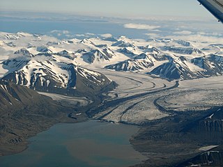
Hambergbreen is a glacier on Spitsbergen, Svalbard, dividing Torell Land and Sørkapp Land, and debouching into the sea at the eastern coast of Spitsbergen. The glacier is named after Swedish geographer and explorer Axel Hamberg.

Fridtjovbreen is a glacier in Nordenskiöld Land at Spitsbergen, Svalbard. It has a length of about 14 kilometers, and debouches into the bay Fridtjovhamna at the northern side of Van Mijenfjorden. The name stems from a hunting vessel used during the Torell expedition to Spitsbergen. The lower part of the glacier is included in the Nordenskiöld Land National Park.
Recherchebreen is a glacier in Wedel Jarlsberg Land at Spitsbergen, Svalbard. The glacier has a length of about 16 kilometers (9.9 mi). It is located in a valley between Martinfjella and Observatoriefjellet, and debouches into Recherche Fjord. Among its tributary glaciers are Foldnutfonna, Varderyggfonna, Dollfusbreen, Ramondbreen and Bjørnbreen.

Renardbreen is a glacier in Wedel Jarlsberg Land at Spitsbergen, Svalbard. The glacier has a length of about 8 kilometers (5.0

Bohlinryggen is a mountain ridge in Wedel Jarlsberg Land at Spitsbergen, Svalbard. It has a length of about 4.5 kilometers, and the highest peak is 716 m.a.s.l. It is located between the glaciers Scottbreen and Renardbreen. The ridge is named after Swedish astronomer Karl Bohlin.

Markhambreen is a glacier in Torell Land at Spitsbergen, Svalbard. It is named after English geographer Clements Robert Markham.
Qvigstadfjellet is a mountain in Nordenskiöld Land at Spitsbergen, Svalbard. It is named after Norwegian philologist and politician Just Knud Qvigstad. The mountain reaches a height of 770 m.a.s.l. It is located between the valley of Orustdalen and the glacier of Vestre Grønfjordbreen, south of Aldegondabreen.
Aldegondabreen is a glacier in Nordenskiöld Land at Spitsbergen, Svalbard, Norway. It is named after Infanta Adelgundes, Duchess of Guimarães. The glacier has a length of about 5.5 kilometers. It flows from Qvigstadfjellet, Christensenfjella and Hermod Petersenfjellet towards Grønfjorden.
Erdmannbreen is a glacier in Nordenskiöld Land at Spitsbergen, Svalbard. It is named after Swedish geologist Axel Joachim Erdmann. The glacier has a length of about six kilometers, and is surrounded by the mountains of Malmberget, Ytterdalsgubben and Kosterfjellet. The river of Ytterdalselva originates from Erdmannbreen and flows through the valley of Ytterdalen to the bay of Van Muydenbukta.
Paulabreen is a glacier in Nathorst Land and Heer Land at Spitsbergen, Svalbard. It has a length of about fifteen kilometers, extending from the mountain of Kjølberget to the bay of Rindersbukta. The glacier is named after Paula, the wife of shipmaster Richard Ritter von Barry. Paulabreen borders to the mountain area of Vriompeisen, and the mountain of Hollertoppen. A tributary glacier is Bakaninbreen.
Bakaninbreen is a glacier in Heer Land at Spitsbergen, Svalbard. It has a length of about 9.5 kilometers, and merges with the glacier of Paulabreen. The glacier is named after a member of the Swedish-Russian Arc-of-Meridian Expedition. The mountain of Hollertoppen is located between Bakaninbreen and Ragna-Mariebreen.
Kvitskarvbreen is a glacier in Nathorst Land at Spitsbergen, Svalbard. It has a length of about 8.5 kilometers, and extend northwestwards from the mountain of Kvitskarvet to the valley of Bromelldalen. The glaciers of Lundbreen, Juvbreen and Zimmerbreen are all tributaries to Kvitskarvbreen.
Steindolpbreen is a glacier in Nathorst Land at Spitsbergen, Svalbard. It extends from Juvtinden and the eastern side of Steindolptoppen to Snøkuvbreen. North of the glacier are the mountains of Rånekampen and Vengefjellet.
Charpentierbreen is a glacier in Nathorst Land at Spitsbergen, Svalbard. It is named after Swiss geologist Jean de Charpentier. The glacier has a length of about four kilometers, and is located within the mountain range of Törnbohmfjella, flowing eastwards from the peak of Såta down to the valley of Davisdalen. The mountain of Venetzhumpen separates Charpentierbreen from Venetzbreen.

Penckbreen is a glacier in Wedel Jarlsberg Land at Spitsbergen, Svalbard. It is named after German geographer Albrecht Penck. The glacier has a length of about 22 kilometers, and is situated west of the mountain ridge of Friherrefjella. Tributary glaciers are Suessbreen, Tirolarbreen and Sveitsarfonna.
Krøkjebreen is a glacier in Torell Land at Spitsbergen, Svalbard. It has a length of nine kilometers. Krøkjebreen is part of the Liestølbreen glacier complex, situated between the mountains of Arrheniusfjellet and Wijkberget.
Glasiologbreen is a glacier in Torell Land at Spitsbergen, Svalbard. The glacier has a length of five kilometers, and is situated between the mountains of Gerdnuten and Wijkberget. Glasiologbreen is part of the Liestølbreen glacier complex.

Wijkanderberget is a mountain in Wedel Jarlsberg Land at Spitsbergen, Svalbard.
Werenskioldbreen is a glacier in Wedel Jarlsberg Land, Svalbard, Norway. The glacier is named after Norwegian geologist and Arctic explorer Werner Werenskiold.
References
- ↑ "Scottbreen (Svalbard)". Norwegian Polar Institute. Archived from the original on 6 May 2016. Retrieved 17 April 2016.
- ↑ "Wijkanderberget (Svalbard)". Norwegian Polar Institute. Archived from the original on 6 May 2016. Retrieved 17 April 2016.
- ↑ "Bohlinryggen (Svalbard)". Norwegian Polar Institute. Archived from the original on 6 May 2016. Retrieved 17 April 2016.
77°32′38″N14°21′25″E / 77.544°N 14.357°E
| | This article about a glacier in Spitsbergen is a stub. You can help Wikipedia by expanding it. |