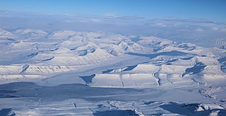
Svalbard, previously known as Spitsbergen or Spitzbergen, is a Norwegian archipelago in the Arctic Ocean. North of mainland Europe, it lies about midway between the northern coast of Norway and the North Pole. The islands of the group range from 74° to 81° north latitude, and from 10° to 35° east longitude. The largest island is Spitsbergen, followed in size by Nordaustlandet and Edgeøya. The largest settlement is Longyearbyen on the west coast of Spitsbergen.

Longyearbyen is the world's northernmost settlement with a population greater than 1,000, and the largest inhabited area of Svalbard, Norway. It stretches along the foot of the left bank of the Longyear Valley and on the shore of Adventfjorden, the short estuary leading into Isfjorden on the west coast of Spitsbergen, the island's broadest inlet. As of 2002 Longyearbyen Community Council became an official Norwegian municipality. It is the seat of the Governor of Svalbard. The town's mayor is Arild Olsen.

Torell Land is a land area at the southeast part of Spitsbergen, Svalbard. It is named after Otto Martin Torell. Two glaciers, Hornbreen and Hambergbreen, divide Torell Land from Sørkapp Land.
Reindalselva is a river in Nordenskiöld Land at Spitsbergen, Svalbard. The river flows through the valley of Reindalen, starting from the mountain pass Reindalspasset, and ending into the bay Kaldbukta in Van Mijenfjorden. It has created one of Svalbard's largest river deltas. Among its tributary rivers are Semmeldalselva and Tverrdalselva.

Grøndalen is a valley in Nordenskiöld Land at Spitsbergen, Svalbard. It has a length of about 19 kilometers. The valley stretches westwards from the mountain pass Grøndalspasset, and debouches into Grønfjorden, at the eastern side of the fjord. The river Grøndalselva flows through the valley.

Fridtjovbreen is a glacier in Nordenskiöld Land at Spitsbergen, Svalbard. It has a length of about 14 kilometers, and debouches into the bay Fridtjovhamna at the northern side of Van Mijenfjorden. The name stems from a hunting vessel used during the Torell expedition to Spitsbergen. The lower part of the glacier is included in the Nordenskiöld Land National Park.

Renardbreen is a glacier in Wedel Jarlsberg Land at Spitsbergen, Svalbard. The glacier has a length of about 8 kilometers (5.0 mi). It is located between the ridges of Activekammen and Bohlinryggen, and debouches into Recherche Fjord.

Bohlinryggen is a mountain ridge in Wedel Jarlsberg Land at Spitsbergen, Svalbard. It has a length of about 4.5 kilometers, and the highest peak is 716 m.a.s.l. It is located between the glaciers Scottbreen and Renardbreen. The ridge is named after Swedish astronomer Karl Bohlin.
Martinfjella is a mountain range in Wedel Jarlsberg Land at Spitsbergen, Svalbard. The range has an extension of about ten kilometers, and is located between the glaciers Antoniabreen and Recherchebreen. Among the mountains are Maria Theresiatoppen, Jarnfjellet, Magnethøgda, Durochertoppen, Bienaimétoppane and Gavltoppane.
Qvigstadfjellet is a mountain in Nordenskiöld Land at Spitsbergen, Svalbard. It is named after Norwegian philologist and politician Just Knud Qvigstad. The mountain reaches a height of 770 m.a.s.l. It is located between the valley of Orustdalen and the glacier of Vestre Grønfjordbreen, south of Aldegondabreen.
Erdmannbreen is a glacier in Nordenskiöld Land at Spitsbergen, Svalbard. It is named after Swedish geologist Axel Joachim Erdmann. The glacier has a length of about six kilometers, and is surrounded by the mountains of Malmberget, Ytterdalsgubben and Kosterfjellet. The river of Ytterdalselva originates from Erdmannbreen and flows through the valley of Ytterdalen to the bay of Van Muydenbukta.

Ytterdalssåta is a mountain in Nordenskiöld Land at Spitsbergen, Svalbard. It has a height of 598 m.a.s.l. and is located between the plain of Lågnesflya and the valley of Ytterdalen. The mountain pass of Ytterskaret separates Ytterdalssåta from the mountain of Skarkampen further north.
Skarkampen is a mountain in Nordenskiöld Land at Spitsbergen, Svalbard. It has a height of 621 m.a.s.l. and is located between the plain of Lågnesflya and the valley of Ytterdalen. The mountain pass of Ytterskaret separates Skarkampen from the mountain of Ytterdalssåta further south.
Langlifjellet is a mountain in Nathorst Land at Spitsbergen, Svalbard. It has peaks with heights of 1,011, 973 and 885 m.a.s.l. respectively. The mountain is surrounded by the mountains of Sven Nilssonfjellet, Bassøefjellet, and Steindolptoppen, and the glaciers of Løyndbreen, Lundbreen and Langlibreen. The valley of Langlidalen separates Langlifjellet and Sven Nilssonfjellet from the mountain of Rånekampen.
Rånekampen is a mountain in Nathorst Land at Spitsbergen, Svalbard. It has a height of 1,185 m.a.s.l. The mountain is located south of Van Mijenfjorden, and is surrounded by the mountains of Vengefjellet, Lundgrenfjellet and Steindolptoppen, and the glaciers of Langlibreen, Steindolpbreen, Vengebreen, and Rånebreen. The valley of Langlidalen separates Rånekampen from the mountains of Langlifjellet and Sven Nilssonfjellet.
Charpentierbreen is a glacier in Nathorst Land at Spitsbergen, Svalbard. It is named after Swiss geologist Jean de Charpentier. The glacier has a length of about four kilometers, and is located within the mountain range of Törnbohmfjella, flowing eastwards from the peak of Såta down to the valley of Davisdalen. The mountain of Venetzhumpen separates Charpentierbreen from Venetzbreen.

Penckbreen is a glacier in Wedel Jarlsberg Land at Spitsbergen, Svalbard. It is named after German geographer Albrecht Penck. The glacier has a length of about 22 kilometers, and is situated west of the mountain ridge of Friherrefjella. Tributary glaciers are Suessbreen, Tirolarbreen and Sveitsarfonna.
Krøkjebreen is a glacier in Torell Land at Spitsbergen, Svalbard. It has a length of nine kilometers. Krøkjebreen is part of the Liestølbreen glacier complex, situated between the mountains of Arrheniusfjellet and Wijkberget.
Glasiologbreen is a glacier in Torell Land at Spitsbergen, Svalbard. The glacier has a length of five kilometers, and is situated between the mountains of Gerdnuten and Wijkberget. Glasiologbreen is part of the Liestølbreen glacier complex.
Scottbreen is a glacier in Wedel Jarlsberg Land at Spitsbergen, Svalbard. The glacier has a length of about 4.5 kilometers. It is located between Wijkanderberget and the ridge of Bohlinryggen, which separates Scottbreen from the glacier of Renardbreen.


