The Norwegian Sea is a marginal sea, grouped with either the Atlantic Ocean or the Arctic Ocean, northwest of Norway between the North Sea and the Greenland Sea, adjoining the Barents Sea to the northeast. In the southwest, it is separated from the Atlantic Ocean by a submarine ridge running between Iceland and the Faroe Islands. To the north, the Jan Mayen Ridge separates it from the Greenland Sea.

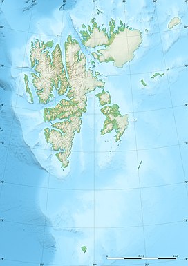
Svalbard, previously known as Spitsbergen or Spitzbergen, is a Norwegian archipelago in the Arctic Ocean. North of mainland Europe, it lies about midway between the northern coast of Norway and the North Pole. The islands of the group range from 74° to 81° north latitude, and from 10° to 35° east longitude. The largest island is Spitsbergen, followed in size by Nordaustlandet and Edgeøya. The largest settlement is Longyearbyen on the west coast of Spitsbergen.

Spitsbergen is the largest and the only permanently populated island of the Svalbard archipelago in northern Norway.

Svalbard and Jan Mayen is a statistical designation defined by ISO 3166-1 for a collective grouping of two remote jurisdictions of Norway: Svalbard and Jan Mayen. While the two are combined for the purposes of the International Organization for Standardization (ISO) category, they are not administratively related. This has further resulted in the country code top-level domain .sj being issued for Svalbard and Jan Mayen, and ISO 3166-2:SJ. The United Nations Statistics Division also uses this code, but has named it the Svalbard and Jan Mayen Islands.

Longyearbyen is the world's northernmost settlement with a population greater than 1,000 and the largest inhabited area of Svalbard, Norway. It stretches along the foot of the left bank of the Longyear Valley and on the shore of Adventfjorden, the short estuary leading into Isfjorden on the west coast of Spitsbergen, the island's broadest inlet. As of 2002 Longyearbyen Community Council became an official Norwegian municipality. It is the seat of the Governor of Svalbard. The town's mayor is Arild Olsen.

The Greenland Sea is a body of water that borders Greenland to the west, the Svalbard archipelago to the east, Fram Strait and the Arctic Ocean to the north, and the Norwegian Sea and Iceland to the south. The Greenland Sea is often defined as part of the Arctic Ocean, sometimes as part of the Atlantic Ocean. However, definitions of the Arctic Ocean and its seas tend to be imprecise or arbitrary. In general usage the term "Arctic Ocean" would exclude the Greenland Sea. In oceanographic studies the Greenland Sea is considered part of the Nordic Seas, along with the Norwegian Sea. The Nordic Seas are the main connection between the Arctic and Atlantic oceans and, as such, could be of great significance in a possible shutdown of thermohaline circulation. In oceanography the Arctic Ocean and Nordic Seas are often referred to collectively as the "Arctic Mediterranean Sea", a marginal sea of the Atlantic.
The High Arctic Large Igneous Province (HALIP) is a Cretaceous large igneous province in the Arctic. The region is divided into several smaller magmatic provinces. Svalbard, Franz Josef Land, Sverdrup Basin, Amerasian Basin, and northern Greenland are some of the larger divisions. Today, HALIP covers an area greater than 1,000,000 km2 (390,000 sq mi), making it one of the largest and most intense magmatic complexes on the planet. However, eroded volcanic sediments in sedimentary strata in Svalbard and Franz Josef Land suggest that an extremely large portion of HALIP volcanics have already been eroded away.

The following outline is provided as an overview of and topical guide to Svalbard:

Lilliehöökfjorden is a 14 kilometer long fjord branch of Krossfjorden in Albert I Land at the northwestern side of Spitsbergen, Svalbard. The fjord is named after Gustaf Bertil Lilliehöök.
Carlsfjella is a mountain ridge in Oscar II Land at Spitsbergen, Svalbard. The ridge has a length of 14 kilometers, is located between St. Jonsfjorden and Løvenskioldfonna, and includes Valentinryggen, Patronen, Knausen and Haraldfjellet. The ridge is named after land owner Carl Otto Løvenskiold.
Jämtlandryggen is a mountain ridge in Oscar II Land at Spitsbergen, Svalbard. It has a length of 26 kilometer, and comprises a number of mountains with altitudes in the range roughly between 750 and 950 meters, including Årefjellet, Svenskane, Bydalsfjellet, Frösöfjellet, Ragundafjellet, Triryggtoppen and Gavltinden (Mediumfjellet). The ridge is located between the glaciers Sveabreen and Wahlenbergbreen.

Värmlandryggen is a mountain ridge in Oscar II Land at Spitsbergen, Svalbard. The ridge has a length of about nine kilometers, and is located at the northern side of Isfjorden, east of Trygghamna and Lovénvatnet, and west of Ymerbukta.The ridge includes the mountains Klaratoppen, Hovtinden, Karlstadtoppen and Svenskegga.
Påskefjella is a mountain ridge in Sørkapp Land at Spitsbergen, Svalbard. It is located south of Hornsund, east of the bay Samarinvågen and glacier Samarinbreen, and west of Chomjakovbreen. The ridge comprises the mountains Tverraksla, Pinsetoppen, Påsketoppen, Julhøgda and Meranfjellet.
Gedenovfjellet is a mountain ridge in Sørkapp Land at Spitsbergen, Svalbard. It has a length of about four kilometers, with a highest peak of 456 m.a.s.l. The ridge is located between Øydebreen and Austjøkulen. It is separated from the northern ridge Isryggen by the mountain pass Isryggpasset. The ridge is named after Russian astronomer Dmitrij Dmitrievich Gedenov.
Grampianfjella is a mountain ridge in Prins Karls Forland, Svalbard. The ridge is named after the Scottish Grampian Mountains. Among the mountains of the ridge are Monacofjellet, Jessiefjellet, Charlesfjellet, Parnasset, Phippsaksla, Nipenosa, Phippsfjellet, Djevletommelen, Klørne, Neglene and Kasinoet.
Sefströmkammen is a mountain ridge in Nordenskiöld Land at Spitsbergen, Svalbard. It has a length of about six kilometers, extending along Aurdalen from Søre Aurdalsbre, and comprises the peak of Hamretoppen and other peaks. The ridge is named after Swedish geologist Nils Gabriel Sefström. The glacier-dammed Kamvatnet is located between Sefströmkammen and Fridtjovbreen. The lower ridge of Flathaugen is proximate to Sefströmkammen.
Målarryggen is a mountain ridge in Haakon VII Land at Spitsbergen, Svalbard. It has a length of about three kilometers, and is located between the glaciers of Hakebreen and Tinayrebreen. The ridge is named in honor of the French painter Jean Paul Louis Tinayre.
Linnéfjella is a mountain ridge in Nordenskiöld Land at Spitsbergen, Svalbard. It is named after Swedish botanist Carl Linnaeus. The ridge contains the mountains of Solryggen, Aagaardtoppen, Griegfjellet and Griegaksla. East of the ridge is the valley of Linnédalen.
Mjellegga is a mountain ridge in Nathorst Land at Spitsbergen, Svalbard. It has a length of about 3.5 kilometers, and its highest peak is 785 m.a.s.l. Surrounding glaciers are Mjellfonna, Greenbreen and Martinbreen. The valley of Davisdalen extends from Mjellegga down to the headland of Davisodden, at the northern side of Van Keulenfjorden.
Kjellmanberget is a mountain ridge in Nathorst Land at Spitsbergen, Svalbard. It is named after the Swedish botanist and Arctic explorer Frans Reinhold Kjellman. The ridge has a length of about five kilometers, extending from Gyllensköldfjellet eastwards to Breskarvet. Its highest peak is 795 m.a.s.l. Surrounding glaciers are Richterbreen, Frysjabreen and Instebreen.