Tunisia is a country in Northern Africa, bordering the Mediterranean Sea, having a western border with Algeria (965 km) and south-eastern border with Libya (459 km) where the width of land tapers to the south-west into the Sahara. The country has north, east and complex east-to-north coasts including the curved Gulf of Gabès, which forms the western part of Africa's Gulf of Sidra. Most of this greater gulf forms the main coast of Libya including the city of Sirte which shares its root name. The country's geographic coordinates are 34°00′N9°00′E. Tunisia occupies an area of 163,610 square kilometres, of which 8,250 are water. The principal and reliable rivers rise in the north of the country with a few notable exceptions from north-east Algeria and flow through the northern plain where sufficient rainfall supports diverse plant cover and irrigated agriculture.

The Tunisian Sahel or more precisely the Central East Tunisia is an area of central eastern Tunisia and one of the six Tunisian regions. It stretches along the eastern shore, from Hammamet in the north to Mahdia in the south, including the governorates of Monastir, Mahdia, Sfax and Sousse. Its name derives from the Arabic word sāḥil (ساحل), meaning "shore" or "coast". The region's economy is based especially on tourism and it contains the second-biggest airport in Tunisia: Monastir Habib Bourguiba International Airport.

Monastir, also called Mestir, is a city on the central coast of Tunisia, in the Sahel area, some 20 kilometres south of Sousse and 162 kilometres south of Tunis. Traditionally a fishing port, Monastir is now a major tourist resort. Its population is about 93,306. It is the capital of Monastir Governorate.

Sousse or Soussa is a city in Tunisia, capital of the Sousse Governorate. Located 140 km (87 mi) south of the capital Tunis, the city has 271,428 inhabitants (2014). Sousse is in the central-east of the country, on the Gulf of Hammamet, which is a part of the Mediterranean Sea. Its economy is based on transport equipment, processed food, olive oil, textiles, and tourism. It is home to the Université de Sousse.

Port El Kantaoui is a tourist complex 10 kilometres north of Sousse city in central Tunisia. It was built in 1979 specifically as a tourist center, around a large artificial harbour that provides mooring with 340 berths for luxury yachts, hosting sporting activities from water skiing to paragliding, and several golf courses.

Hammam Sousse is a coastal town in eastern Tunisia. It is located north of Sousse. It has about 42,691 inhabitants in 2014.

Sousse Governorate is one of the twenty-four governorates (provinces) of Tunisia. It is beside the eastern coast of Tunisia in the north-east of the country and covers an area of 2,621 km2 and has a population of 674,971. The capital is Sousse.
Uzita was a Roman period town and bishopric in the Roman province of Byzacena, in present-day Tunisia. It continues to be a Latin Catholic titular see.

Tinja or Tindja (تينجة) is a town and commune (municipality) in the Bizerte Governorate, in northern Tunisia, on the shores of Lake Ichkeul. Its name derives from that of the ancient Roman era city of Thimida, a former bishopric which remains a Latin Catholic titular see.
Hiboun is a town and commune in the Mahdia Governorate, Tunisia, located in Sahel, Tunisia region south of Monastir and southeast of Sousse in tourist area and contain many hotels and nightclubs and universities. As of 2009 it had a population of 23,241.
Ezzouhour (Arabic:الزهور) is a town and commune in the Sousse Governorate, Tunisia. As of 2014 it had a population of 17,348. Ezzouhour was originally a spontaneous locality that formed as migrants from the countryside of other areas of Sousse and the neighbouring governorate of Kairouan settled there. It was then connected to public services and integrated in the urban area of Sousse.

Kalaa Sghira is a town and commune in the Sousse Governorate, Tunisia. As of 2004 it had a population of 25,078.
Messaadine or Messaâdine is a town and commune in the Sousse Governorate, Tunisia, located four kilometres northeast of M'saken and seven kilometres southwest of Sousse, along Route RN1, a highway connecting Sousse and M'saken. Administratively part of M'saken, it had a population of 12,916 inhabitants in 2014.
Sidi Bou Ali is a town and commune in the Sousse Governorate, Tunisia. As of 2004 it had a population of 9,011.
Sidi El Hani is a town and commune in the Sousse Governorate, Tunisia located at 35.67n, 10.30e. As of 2004 it had a population of 3,058. It gives its name to the largest lake of the governorate, a natural salt lake or salt pan (sabkha) in dry seasons, the Sebkhet de Sidi El Hani which is shared with between one and two other areas depending on precipitation and its maximum extent forms the official boundary with part of a third, Monastir Governorate. The town is 30 km south-west of the coast, its straightest connection being by Tunisian Railways, with a secondary connection by road, the P12 road which is a principal road to Kairouan from the A1 a few kilometres to the east. it is 19 km from Kairouan and 26 km from Raqqada.
Zaouiet Sousse is a town and commune in the Sousse Governorate, Tunisia. As of 2014 it had a population of 20,681.

Dhorbania, also known as Henchir Oued Nebhana, is a village and locality in Tunisia. It's also the site of Ancient city and former bishopric Bahanna, now a Latin Catholic titular see.

Chott Meriem is a city of the Sahel, Tunisia located on the Mediterranean coast just north of Sousse.
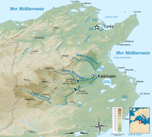
Oued Merguellil is a stream in central Tunisia that flows via Sebkhet Cherita Lake, into the Mediterranean at the Gulf of Hammamet.

The Sebkha Kelbia is an intermittent lake in Tunisia that covers 8000 hectares in Sousse Governorate, at 35°50'34"North, 10°16'18"East, south of Kondar.