
Bavaria, officially the Free State of Bavaria, is a landlocked state of Germany, occupying its southeastern corner. With an area of 70,550.19 square kilometres (27,239.58 sq mi) Bavaria is the largest German state by land area comprising roughly a fifth of the total land area of Germany. With 13 million inhabitants, it is Germany's second-most-populous state after North Rhine-Westphalia. Bavaria's main cities are Munich, Nuremberg, and Augsburg.

Swabia is one of the seven administrative regions of Bavaria, Germany.

Upper Franconia is a Regierungsbezirk of the state of Bavaria, southern Germany. It forms part of the historically significant region of Franconia, all now part of the German Federal State of Bayern (Bavaria).
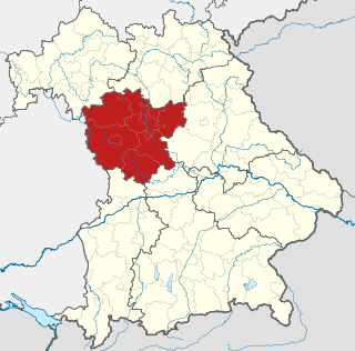
Middle Franconia is one of the three administrative regions of Franconia in Bavaria, Germany. It is located in the west of Bavaria and borders the state of Baden-Württemberg. The administrative seat is Ansbach; however, the most populous city is Nuremberg.

Upper Bavaria is one of the seven administrative districts of Bavaria, Germany.
Lower Bavaria is one of the seven administrative regions of Bavaria, Germany, located in the east of the state.

The Upper Palatinate is one of the seven administrative districts of Bavaria, Germany, located in the east of Bavaria.

The Iller (help·info) is a river of Bavaria and Baden-Württemberg in Germany. It is a right tributary of the Danube, 146 kilometres (91 mi) long.
Altötting is a Landkreis (district) in Bavaria, Germany. It is bounded by Austria and the Bavarian districts of Traunstein, Mühldorf and Rottal-Inn.

Freyung-Grafenau is a Landkreis (district) in Bavaria, Germany. It is bounded by the districts of Passau, Deggendorf and Regen, the Czech Republic and by Austria.

Landshut is a town in Bavaria in the south-east of Germany. Situated on the banks of the River Isar, Landshut is the capital of Lower Bavaria, one of the seven administrative regions of the Free State of Bavaria. It is also the seat of the surrounding district, and has a population of more than 70,000. Landshut is the largest city in Lower Bavaria, followed by Passau and Straubing, and Eastern Bavaria's second biggest city.

Bavarians are an ethnographic group of Germans of the Bavaria region, a state within Germany. The group's dialect or speech is known as the Bavarian language, native to Altbayern, roughly the territory of the Electorate of Bavaria in the 17th century.

Kelheim is a town and municipality in Bavaria, Germany. It is the capital of the district Kelheim and is situated at the confluence of the rivers Altmühl and Danube. Kelheim has a population of around 15,750.
The Duchy of Bavaria was a frontier region in the southeastern part of the Merovingian kingdom from the sixth through the eighth century. It was settled by Bavarian tribes and ruled by dukes (duces) under Frankish overlordship. A new duchy was created from this area during the decline of the Carolingian Empire in the late ninth century. It became one of the stem duchies of the East Frankish realm which evolved as the Kingdom of Germany and the Holy Roman Empire.
The Kingdom of Bavaria was a German state that succeeded the former Electorate of Bavaria in 1805 and continued to exist until 1918. The Bavarian Elector Maximilian IV Joseph of the House of Wittelsbach became the first King of Bavaria in 1805 as Maximilian I Joseph. The crown would go on being held by the Wittelsbachs until the kingdom came to an end in 1918. Most of Bavaria's present-day borders were established after 1814 with the Treaty of Paris, in which Bavaria ceded Tyrol and Vorarlberg to the Austrian Empire while receiving Aschaffenburg and Würzburg. With the unification of Germany into the German Empire in 1871, the kingdom became a federated state of the new empire and was second in size, power, and wealth only to the leading state, the Kingdom of Prussia. In 1918, Bavaria became a republic after the German Revolution, and the kingdom was thus succeeded by the current Free State of Bavaria.

Albert III the Pious of Bavaria-Munich, since 1438 Duke of Bavaria-Munich. He was born in Wolfratshausen to Ernest, Duke of Bavaria and Elisabetta Visconti, daughter of Bernabò Visconti.
Southern Germany as a region has no exact boundary but is generally taken to include the areas in which Upper German dialects are spoken. That corresponds roughly to the historical stem duchies of Bavaria and Swabia or, in a modern context, to Bavaria and Baden-Württemberg within the Federal Republic of Germany, to the exclusion of the areas of the modern states of Austria and Switzerland. The Saarland and the southern parts of Hesse and Rhineland-Palatinate are sometimes included as well and correspond to the historical Franconia.
Main-Franconian is group of Upper German dialects being part of the East Franconian group. The name is derived from the river Main which meets the river Rhine near Frankfurt after having crossed the former West Germany from East to West. The dialect is estimated by Ethnologue as 40% intelligible with Standard German.

The Margraviate of Austria was a southeastern frontier march of the Holy Roman Empire created in 803 by Charlemagne on the banks of the Danube. It was originally put under the overlordship of the Dukes of Bavaria and served as a bulwark against the ever threatening onrushes of the Avars. Raided by Magyars in the 10th century, it was ruled by margraves of the Franconian Babenberg dynasty since 976 with the scope of protecting the Empire's border with the Principality of Hungary. It became an Imperial State in its own right, when the Babenbergs were elevated to Dukes of Austria in 1156.

The Danube is Europe's second-longest river, after the Volga. It is located in Central and Eastern Europe.
