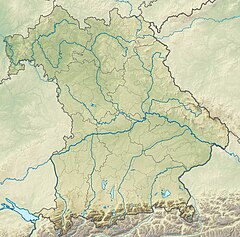
The Main is the longest tributary of the Rhine. It rises as the White Main in the Fichtel Mountains of northeastern Bavaria and flows west through central Germany for 525 kilometres (326 mi) to meet the Rhine below Rüsselsheim, Hesse. The cities of Mainz and Wiesbaden are close to the confluence.

Aschaffenburg is a town in northwest Bavaria, Germany. The town of Aschaffenburg is not part of the district of Aschaffenburg, but is its administrative seat.

Spessart is a Mittelgebirge, a range of low wooded mountains, in the States of Bavaria and Hesse in Germany. It is bordered by the Vogelsberg, Rhön and Odenwald. The highest elevation is the Geiersberg at 586 metres above sea level.

The Isar is a river in Austria and in Bavaria, Germany. Its source is in the Karwendel mountain range of the Alps. The Isar river enters Germany near Mittenwald and flows through Bad Tölz, Munich, and Landshut before reaching the Danube near Deggendorf. With 295 km length, it is among the longest rivers in Bavaria. It is Germany's second most important tributary of the Danube.

The Tauber is a river in Franconia, Germany. It is a left tributary of the Main and is 132 km (82 mi) in length. The name derives from the Celtic word for water.

Kleinkahl is a community in the Aschaffenburg district in the Regierungsbezirk of Lower Franconia (Unterfranken) in Bavaria, Germany, and a member of the Verwaltungsgemeinschaft of Schöllkrippen. Kleinkahl has around 1,800 inhabitants.
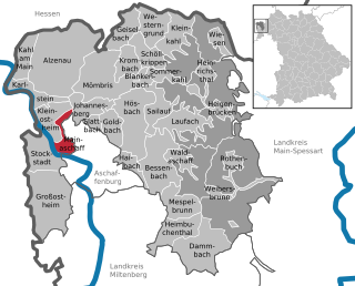
Mainaschaff is a community in the Aschaffenburg district in the Regierungsbezirk of Lower Franconia (Unterfranken) in Bavaria, Germany. It has a population of around 9,000 (2020).

The Ludwig Western Railway is a German railway line that was originally funded by the Kingdom of Bavaria. It runs from Bamberg via Würzburg to Aschaffenburg and on into the former "Kurhessian" Hanau.

The Sinn is a river that flows through the state of Hesse and the Bavarian province of Lower Franconia in southern Germany. It is about 69 kilometres (43 mi) long and is a right, northerly tributary of the Franconian Saale.

The Kahl is a river in the northern Spessart in Bavaria and Hesse, Germany. It is a right tributary of the Main and is 35.6 km (22.1 mi) long. The name Kahl comes from the Old High German word kaldaha, which means cool and clear. The Kahl rises from two sources left and right of the road at the foot of the Spessart hills, near Kleinkahl. These springs produce 50–60 litres per second. The Kahl flows into the river Main in Kahl am Main. The mouth is near the old Kahl Nuclear Power Plant. The largest tributaries are Westerbach, Sommerkahl, Reichenbach and Geiselbach.

Glattbach is a small river of Bavaria, Germany. It flows into the Aschaff near Aschaffenburg.

Hafenlohr is a river of Bavaria, Germany. It is around 28 km (17 mi) long and discharges into the Main at the town of Hafenlohr. The Hafenlohr is located in the districts of Aschaffenburg and Main-Spessart in the Lower Franconia region.

Hösbach is a river of Bavaria, Germany, at the market community Hösbach in the Aschaffenburg district in the Regierungsbezirk of Lower Franconia (Unterfranken).

Laufach is a river of Bavaria, Germany. It flows into the Aschaff near Hösbach.

Elsava is a 27-kilometre-long (17 mi) right tributary of the Main in the administrative districts Aschaffenburg and Miltenberg in the Bavarian Spessart. It flows into the river Main in Elsenfeld. The short section upstream from Hessenthal to Mespelbrunn is called Kaltenbach.

Goldbach is a small river of Bavaria, Germany. It is a right tributary of the Aschaff near Aschaffenburg.

Gersprenz is a river that starts in the Odenwald, Hesse and flows into the river Main near Aschaffenburg, Bavaria, Germany. Including its source river Mergbach, it is 62.1 km (38.6 mi) long, without the Mergbach it is 51.3 km (31.9 mi) long.

Welzbach is a river of Hesse and Bavaria, Germany. It is a left tributary of the Main at the district Leider of Aschaffenburg.

Lohmgraben is a small river of Bavaria, Germany. It is formed by the confluence of two small streams: Fahrbach and Grundgraben. It flows into the Aschaff near Aschaffenburg.