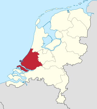
South Holland is a province of the Netherlands with a population of over 3.8 million as of January 2023 and a population density of about 1,410/km2 (3,700/sq mi), making it the country's most populous province and one of the world's most densely populated areas. Situated on the North Sea in the west of the Netherlands, South Holland covers an area of 3,308 km2 (1,277 sq mi), of which 609 km2 (235 sq mi) is water. It borders North Holland to the north, Utrecht and Gelderland to the east, and North Brabant and Zeeland to the south. The provincial capital is the Dutch seat of government The Hague, while its largest city is Rotterdam. The Rhine-Meuse-Scheldt delta drains through South Holland into the North Sea. Europe's busiest seaport, the Port of Rotterdam, is located in South Holland.
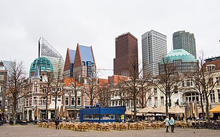
The Hague is the capital city of the South Holland province of the Netherlands. With a population of over half a million, it is the third-largest city in the Netherlands. Situated on the west coast facing the North Sea, The Hague is the country's administrative centre and its seat of government, and while the official capital of the Netherlands is Amsterdam, The Hague has been described as the country's de facto capital since the time of the Dutch Republic.

Berkel en Rodenrijs is a town and former municipality in the municipality of Lansingerland, in the province of South Holland, The Netherlands. The town is very close to Rotterdam.

Leidschendam-Voorburg is a municipality in the Western Netherlands, in the province of South Holland, just northeast of The Hague. It had a population of 76,433 in 2021, and covers an area of 35.62 km2 (13.75 sq mi) of which 3.07 km2 (1.19 sq mi) is water.

Zoetermeer is a city in the Western Netherlands, in the province of South Holland. The municipality covers an area of 37.05 km2 (14.31 sq mi) of which 2.60 km2 (1.00 sq mi) is water. A small village until the late 1960s, it had 6,392 inhabitants in 1950. By 2023 this had grown to 126.998, making it the fourth largest population centre in the province of South Holland, after Rotterdam, The Hague and Leiden. While now a city in its own right, Zoetermeer started out as a suburb of The Hague and is still a part of the Greater The Hague urban area.

Zoeterwoude is a municipality in the province of South Holland, Western Netherlands. It covers 21.96 km2 (8.48 sq mi) of which 0.77 km2 (0.30 sq mi) is water. It had a population of 8,843 in 2021.

HTM Personenvervoer NV is a public transport company in the Netherlands operating trams, lightrail and buses in The Hague, Rijswijk, Leidschendam, Voorburg, Delft, Zoetermeer, Wateringen, Pijnacker and Nootdorp, the so-called Conurbation Haaglanden. The lightrail connection to Zoetermeer is operated in cooperation with RET, the Rotterdam-public transport company, which operates the connection between The Hague Central Station and Slinge in the south of Rotterdam, thus giving a fast and easy connection between the two city-centres. Regional transports are serviced by Connexxion, Arriva and RET.
Pijnacker is a town in the Dutch province of South Holland. It is bordered by Zoetermeer to the north, by Nootdorp to the northwest, by Delfgauw to the southwest, by Rotterdam to the south and by Berkel en Rodenrijs to the east.

Nootdorp is a small town in the Dutch province of South Holland. It is bordered by Zoetermeer to the north, by The Hague to the west, by Delfgauw to the south and by Pijnacker to the east. Nootdorp was a separate municipality until 2002, when it merged with Pijnacker to form Pijnacker-Nootdorp, which is a part of Greater The Hague.
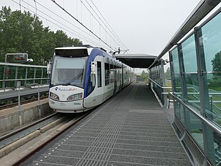
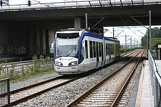
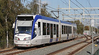
RandstadRail is a tram-train network in the Rotterdam–The Hague metropolitan area in the west of the Netherlands that is jointly operated by HTM Personenvervoer (HTM) and Rotterdamse Elektrische Tram (RET). It connects the cities of Rotterdam, The Hague and Zoetermeer, primarily using former train and existing tram tracks.

Suriname has possibly the highest proportion of Hindus who are Arya Samajis, compared to any other country. In Suriname, the Hindu population had split, with roughly 20% following the teachings of Swami Dayanand Saraswati, founder of the Ārya Samāj, and 80% following the Sanatan Dharm. According to the census of 2012 the number of Ārya Samājĩs is 16,661. The arrival of Arya Samaj preachers in Suriname, in 1929, caused a rift in the Hindu community, between the followers of Sanātanī and the Ārya Samāj.
Moerkapelle is a village in the Dutch province of South Holland. It is located about 6 km east of the city of Zoetermeer, in the municipality of Zuidplas.

Zegwaart was a village in the Dutch province of South Holland. It was located directly to the east of Zoetermeer. Around 1978 a division of Zoetermeer was named after the old village and got the name Seghwaert.

Den Haag Laan van NOI railway station is a railway station in the Netherlands, on the border between The Hague and the town of Voorburg. It is served by the Nederlandse Spoorwegen and by the RandstadRail light-rail network. The station is named after the road on which it is located, Laan van Nieuw Oost-Indië, which literally translates as New East Indies Avenue, but probably refers to a former inn called Nieuw Oosteinde.
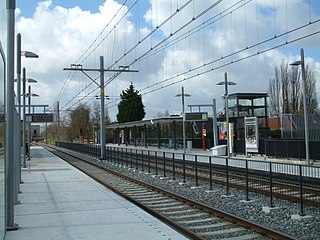
Zoetermeer Stadslijn is a light-rail line converted from a former commuter rail line in the Netherlands, between The Hague and Zoetermeer.
Seghwaert is a RandstadRail station in Zoetermeer, the Netherlands.

Javalaan is a RandstadRail station in Zoetermeer, Netherlands. It is the final stop of line 4, located on a viaduct. The station opened on 8 October 2007, as part of the Oosterheemlijn.
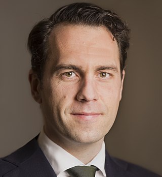
Martinus Hendricus Petrus "Martijn" van Dam is a Dutch engineer and politician. A member of the Labour Party (PvdA), he served as State Secretary for Economic Affairs from 3 November, 2015 until 1 September, 2017 in the Second Rutte cabinet. He was a member of the House of Representatives between 2003 and 2015. He previously served as councillor for the municipality of Eindhoven from April 1998 to January 2003. From the time he entered the States General on 30 January 2003 to 29 November 2006, he was the youngest member of the House.
The Hague Tram is a tram network forming part of the public transport system in and around the city of The Hague in South Holland, Netherlands.

Adrianus Johannes Maria "Adriaan" van Well was a Dutch entrepreneur, credited as the founder of the supermarket chain Spar on 28 June 1932.


