Sekicol

Last updated
Sekicol
Village
Serbia adm location map.svg
Red pog.svg
Sekicol
Coordinates: 42°58′48″N21°40′48″E / 42.98000°N 21.68000°E / 42.98000; 21.68000
CountryFlag of Serbia.svg  Serbia
District Jablanica District
Municipality Lebane
Population (2002)
  Total 57
Time zone CET (UTC+1)
  Summer (DST) CEST (UTC+2)

Sekicol is a village in the municipality of Lebane, Serbia. According to the 2002 census, the village has a population of 57 people. [1]

Village Small clustered human settlement smaller than a town

A village is a clustered human settlement or community, larger than a hamlet but smaller than a town, with a population ranging from a few hundred to a few thousand. Though villages are often located in rural areas, the term urban village is also applied to certain urban neighborhoods. Villages are normally permanent, with fixed dwellings; however, transient villages can occur. Further, the dwellings of a village are fairly close to one another, not scattered broadly over the landscape, as a dispersed settlement.

Lebane Town and municipality in Southern and Eastern Serbia, Serbia

Lebane is a town and municipality located in Jablanica District of southern Serbia. According to the 2011 census, the town has a population of 10,062 inhabitants, while the municipality has 20,000 inhabitants.

Serbia Republic in Southeastern Europe

Serbia, officially the Republic of Serbia, is a country situated at the crossroads of Central and Southeast Europe in the southern Pannonian Plain and the central Balkans. The sovereign state borders Hungary to the north, Romania to the northeast, Bulgaria to the southeast, North Macedonia to the south, Croatia and Bosnia and Herzegovina to the west, and Montenegro to the southwest. The country claims a border with Albania through the disputed territory of Kosovo. Serbia's population is about seven million. Its capital, Belgrade, ranks among the oldest and largest citiеs in Europe.

Related Research Articles

Litošice Village in Pardubice county of Pardubice region

Litošice is a small village in the Pardubice Region of the Czech Republic. It has around 100 inhabitants.

Kraljevec na Sutli municipality of Croatia

Kraljevec na Sutli is a village and municipality in Krapina-Zagorje County in Croatia. According to the 2011 census, there are 1,727 inhabitants in the area, absolute majority of which are Croats.

Novi Golubovec municipality of Croatia

Novi Golubovec is a village and municipality in Krapina-Zagorje County in Croatia. According to the 2011 census, there are 996 inhabitants in the area, absolute majority of which are Croats.

Yokokura Station (Nagano) railway station in Sakae, Shimominochi district, Nagano prefecture, Japan

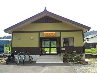
Yokokura Station is a railway station in the Iiyama Line, East Japan Railway Company, in Hokushin in the village of Sakae, Shimominochi District, Nagano Prefecture, Japan.

Kuchmy-Pietruki is a village in the administrative district of Gmina Michałowo, within Białystok County, Podlaskie Voivodeship, in north-eastern Poland, close to the border with Belarus.

Obârșia de Câmp is a commune located in Mehedinți County, Romania. It is composed of two villages, Izimșa and Obârșia de Câmp.

Pərioğlular, Agdam Place in Agdam, Azerbaijan

Pərioğlular is a village in the Agdam Rayon of Azerbaijan.

Magonie Village in Świętokrzyskie, Poland

Magonie is a village in the administrative district of Gmina Bodzechów, within Ostrowiec County, Świętokrzyskie Voivodeship, in south-central Poland. It lies approximately 10 kilometres (6 mi) north-east of Ostrowiec Świętokrzyski and 64 km (40 mi) east of the regional capital Kielce.

Biskupice is a village in the administrative district of Gmina Drobin, within Płock County, Masovian Voivodeship, in east-central Poland.

Wólka Zaleska is a village in the administrative district of Gmina Pokrzywnica, within Pułtusk County, Masovian Voivodeship, in east-central Poland.

Wólka Wręcka Village in Masovian, Poland

Wólka Wręcka is a village in the administrative district of Gmina Mszczonów, within Żyrardów County, Masovian Voivodeship, in east-central Poland. It lies approximately 7 kilometres (4 mi) west of Mszczonów, 8 km (5 mi) south of Żyrardów, and 47 km (29 mi) south-west of Warsaw.

Chełkowo is a village in the administrative district of Gmina Śmigiel, within Kościan County, Greater Poland Voivodeship, in west-central Poland.

Jezierzyce is a village in the administrative district of Gmina Śmigiel, within Kościan County, Greater Poland Voivodeship, in west-central Poland.

Nowa Cerkiew Szlachetna Village in Pomeranian, Poland

Nowa Cerkiew Szlachetna is a village in the administrative district of Gmina Chojnice, within Chojnice County, Pomeranian Voivodeship, in northern Poland. It lies approximately 9 kilometres (6 mi) east of Chojnice and 96 km (60 mi) south-west of the regional capital Gdańsk.

Nasutowo Village in West Pomeranian, Poland

Nasutowo is a village in the administrative district of Gmina Białogard, within Białogard County, West Pomeranian Voivodeship, in north-western Poland. It lies approximately 9 kilometres (6 mi) west of Białogard and 105 km (65 mi) north-east of the regional capital Szczecin.

Luśno Settlement in West Pomeranian, Poland

Luśno is a settlement in the administrative district of Gmina Barlinek, within Myślibórz County, West Pomeranian Voivodeship, in north-western Poland. It lies approximately 6 kilometres (4 mi) south-east of Barlinek, 28 km (17 mi) east of Myślibórz, and 67 km (42 mi) south-east of the regional capital Szczecin.

Terjola Municipality District in Georgia

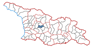
Terjola is a district of Georgia, in the region of Imereti. Its main town is Terjola.

Dan-Goulbi is a village and rural commune in Niger.

El Bradâa is a town and commune in the Mahdia Governorate, Tunisia. As of 2004 it had a population of 6,416.

Urmanica Village in Pčinja District, Serbia

Urmanica is a village in the municipality of Vranje, Serbia. According to the 2002 census, the village has a population of 32 people.

References

  1. Popis stanovništva, domaćinstava i Stanova 2002. Knjiga 1: Nacionalna ili etnička pripadnost po naseljima. Republika Srbija, Republički zavod za statistiku Beograd 2003. ISBN   86-84433-00-9

Coordinates: 42°58′48″N21°40′48″E / 42.98000°N 21.68000°E / 42.98000; 21.68000

Geographic coordinate system Coordinate system

A geographic coordinate system is a coordinate system that enables every location on Earth to be specified by a set of numbers, letters or symbols. The coordinates are often chosen such that one of the numbers represents a vertical position and two or three of the numbers represent a horizontal position; alternatively, a geographic position may be expressed in a combined three-dimensional Cartesian vector. A common choice of coordinates is latitude, longitude and elevation. To specify a location on a plane requires a map projection.