The road starts in South Norwood from the High Street, which is also part of the A213, then it carries on to Selhurst railway station opposite Heavers Meadow then on a side road it passes the BRIT School. The road carries on until it meets Northcote Road at a corner, this road carries on until it hits a five way junction with Whitehorse Road (towards Thornton Heath and Croydon), Windmill Road (towards Purley Way), Limes Road (residential) and Hampton Road (retail). The road passes four different schools within only 1,500 metres of each other.
The London Borough of Croydon is a London borough in south London, part of Outer London. It covers an area of 87 km2 (33.6 sq mi). It is the southernmost borough of London. At its centre is the historic town of Croydon from which the borough takes its name; while other urban centres include Coulsdon, Purley, South Norwood, Norbury, New Addington, Selsdon and Thornton Heath. Croydon is mentioned in Domesday Book, and from a small market town has expanded into one of the most populous areas on the fringe of London. The borough is now one of London's leading business, financial and cultural centres, and its influence in entertainment and the arts contribute to its status as a major metropolitan centre. Its population is 390,719, making it the most populous London borough and sixteenth largest English district.
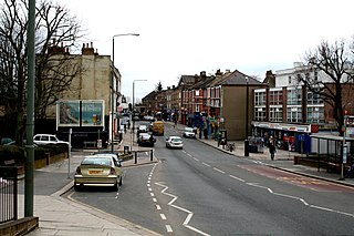
Thornton Heath is a district of South London, England, within the London Borough of Croydon. It is around 1.5 miles (2.4 km) north of the town of Croydon, and 7.2 miles (11.6 km) south of Charing Cross. Prior to the creation of Greater London in 1965, Thornton Heath was in the County Borough of Croydon.
Croydon is a large town in South London, England, 9.3 miles (15.0 km) south of Charing Cross. Part of the London Borough of Croydon, a local government district of Greater London, it is one of the largest commercial districts in Greater London, with an extensive shopping district. The entire town had a population of 192,064 as of 2011, whilst the wider borough had a population of 384,837.
East Croydon is a railway station, tram stop and associated bus station in Croydon, Greater London, England. It is located in Travelcard Zone 5. At 10 miles 28 chains from London Bridge, it is the 20th busiest station in Britain, was the 10th busiest in 2020–21, is the busiest national rail station in London outside of fare zones 1 and 2 and is one of the busiest non-terminal stations in the country. It is one of three railway stations in the London Borough of Croydon with Croydon in their name, the others being West Croydon and South Croydon. A Tramlink tram stop is located immediately outside the main station entrance.
The Croydon Canal ran 9+1⁄4 miles (15 km) from Croydon, via Forest Hill, to the Grand Surrey Canal at New Cross in south London, England. It opened in 1809 and closed in 1836, the first canal to be abandoned by an act of Parliament.
South Norwood is a district of south-east London, England, within the London Borough of Croydon, Greater London and formerly in the historic county of Surrey. It is located 7.8 miles (12.5 km) south-east of Charing Cross, north of Woodside and Addiscombe, east of Selhurst and Thornton Heath, south of Crystal Palace/Upper Norwood and Anerley, and south-west of Penge.
Norwood Junction railway station is a National Rail station in South Norwood in the London Borough of Croydon, south London, and is in Travelcard Zone 4. It is 8 miles 55 chains down the line from London Bridge.
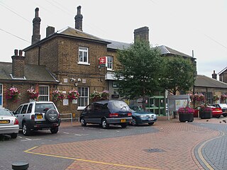
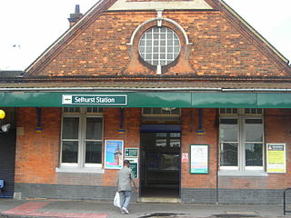
Selhurst railway station is in the London Borough of Croydon in south London, 9 miles 31 chains (15.1 km) along the line from London Victoria. It is operated by Southern, which also provides all the train services. The station is in Travelcard Zone 4.
Arena tram stop is a light rail stop in the Woodside area of South Norwood in the London Borough of Croydon in the southern suburbs of London. The stop is located by the Croydon Sports Arena and serves the council estates of Longheath Gardens Estate and Tollgate Estate.
Woodside is an area in south London, in the London Borough of Croydon. It is between Addiscombe and South Norwood. It is south of South Norwood, west of Shirley and Monks Orchard, north of Addiscombe, and east of Selhurst.
Anerley is suburb of south east London, England, within the London Borough of Bromley. It is located 7 miles (11 km) south south-east of Charing Cross, to the south of Upper Norwood, west of Penge, north of Elmers End and east of South Norwood. The northern edge of Anerley contains part of the area commonly known as Crystal Palace, and the site of the ancient Vicar's Oak where the London boroughs of Bromley, Croydon, Lambeth and Southwark meet, with Lewisham 800 yards (740m) away.
Croydon North West was a borough constituency represented in the House of Commons of the Parliament of the United Kingdom. It elected one Member of Parliament (MP) by the first past the post system of election.
Central Croydon railway station in Croydon, England, was a largely unsuccessful venture by the London Brighton and South Coast Railway to bring trains closer to the centre of Croydon, as East Croydon station was deemed too far from the busy town centre. It originally opened in 1868 and closed in 1871: it then reopened in 1886, before closing permanently in 1890. Its site was used for the building of Croydon Town Hall, erected in 1892–1896.
The A215 is an A road in south London, starting at Elephant and Castle and finishing around Shirley. It runs through the London Boroughs of Lambeth, Southwark and Croydon.
The Great North Wood was a natural oak woodland that started three miles (4.8 km) south-east of central London and scaled the Norwood Ridge. At its full extent, the wood's boundaries stretched almost as far as Croydon and as far north as Camberwell. It had occasional landownings as large clearings, well-established by the Middle Ages such as the hamlets of Penge and Dulwich.
London Buses route 75 is a Transport for London contracted bus route in London, England. Running between Fairfield Halls and Lewisham station, it is operated by Stagecoach London.
Heavers Meadow is a meadow located in South Norwood and Selhurst in the London Borough of Croydon. South Norwood Recreation Ground is on the other side of the road. The meadow covers an area of 83⁄4 acres. With meadows there are not usually many facilities. Heavers is no exception; the only facility stated on the council's website is a footpath through a flood meadow.
Selhurst is an area in the London Borough of Croydon, England, 7.8 miles (12.6 km) south-south-east of Charing Cross. Historically it lays in Surrey. The area is bounded to the west and south by Thornton Heath and Croydon and to the east and south by South Norwood and Woodside. Selhurst Park, the home stadium of Crystal Palace Football Club, is sited at the northern end of the neighbourhood.
South Norwood Library is a purpose-built public library in South Norwood, South London. Also known locally as 'Brutalist Library' it stands in the London Borough of Croydon and is part of the Croydon Libraries arm of the council. The site on the corner of Selhurst Road and Lawrence Road first had a library built in 1897, which was replaced by the current building in 1966.
Grangewood Park is an extensive woodland area situated in South Norwood, London. It is managed by the London Borough of Croydon. It is bounded by Grange Road, Wharncliffe Road, and Ross Road. It covers an area of 27.7 acres. The park is located on the main A212 road between Thornton Heath and Upper Norwood/Crystal Palace. The nearest stations are Thornton Heath, Selhurst and Norwood Junction.
This page is based on this Wikipedia article Text is available under the CC BY-SA 4.0 license; additional terms may apply. Images, videos and audio are available under their respective licenses.