Arghakhanchi is one of the districts of Lumbini Province in Nepal. The district headquarter is Sandhikharka. The district covers an area of 1,193 km2 (461 sq mi) and has a population (2011) of 197,632. Its neighboring districts are Palpa in the east, Gulmi in the north, Kapilvastu District in the south and Pyuthan in the west.

Dadeldhura district, a part of Sudurpashchim Province, is one of the seventy-seven districts of Nepal. The district, with Dadeldhura as its district headquarters, covers an area of 1,538 km2 (594 sq mi) and had a population of 126,162 in 2001 and 142,094 in 2011.
Gorkha District, a part of Gandaki Province, is one of the 77 districts of Nepal, which is the fourth largest district of Nepal and connected historically with the creation of the modern Nepal and the name of the legendary Gorkha soldiers. The district, with Gorkha Municipality as its district headquarters, covers an area of 3,610 km2 (1,390 sq mi) and has a population of 252,201 according to the 2021 Nepal census. Gorkha district is the site of the Manakamana Temple. The temples of Gorakh Nath and Gorakh Kali are found in the district. Several major rivers—the Chepe, Daraudi, Marsyangdi, Budi Gandaki, and Trishuli—run through the district.

Lamjung District, a part of Gandaki Province, is one of the 77 districts of Nepal. The district, with Besisahar as its district headquarters, covers an area of 1,692 square kilometres (653 sq mi) and as of 2011 had a population of 167,724. Lamjung lies in the mid-hills of Nepal spanning tropical to trans-Himalayan geo-ecological belts, including the geographical midpoint of the country. It has mixed habitation of casts and ethnicities. It is host to probably the highest density of the Gurung ethnic population in the country.

Mugu District, a part of Karnali Province, is one of the seventy-seven districts of Nepal. The district, with Gamgadhi as its district headquarters, covers an area of 3,535 km2 (1,365 sq mi) and had a population (2011) of 55,286. Mugu is known for being both the most remote district in Nepal, as well as the least developed.

Solukhumbu District (Nepali: सोलुखुम्बु जिल्ला[solukʰumbu], Sherpa: ཤར་ཁུམ་བུ་རྫོང་།, Wylie: shar khum bu dzong) is one of 14 districts of Province No. 1 of eastern Nepal. As the name suggests, it consists of the subregions Solu and Khumbu.

A village development committee in Nepal was the lower administrative part of its Ministry of Federal Affairs and Local Development. Each district had several VDCs, similar to municipalities but with greater public-government interaction and administration. There were 3,157 village development committees in Nepal. Each village development committee was further divided into several wards depending on the population of the district, the average being nine wards.
The 1991 Nepal census was a widespread national census conducted by the Nepal Central Bureau of Statistics.
Listikot is a village in Sindhupalchok District in the Bagmati Zone of central Nepal. At the time of the 1991 Nepal census it had a population of 3664 and had 714 houses in the village.
Dhapasi is a residentially preferred village and former Village Development Committee that is now part of Tokha Municipality, just outside the Kathmandu Ring Road, in Kathmandu District in Province No. 3 of central Nepal. At the time of the 2011 Nepal census it had a population of 31,406 and had 8,202 households in it.
Borlang is a village development committee in northern-central Nepal. As of the 1991 Nepal census it had a population of 4,737 and had 837 houses.
Mahadevsthan Mandan is a village development committee in Kavrepalanchok District in the Bagmati Zone of central Nepal.

Katahariya is a municipality in Rautahat District in the Narayani Zone of south-eastern Nepal. Before September 2017, Katahariya was one of the Village Development Committees with 8 wards. At the time of the 1991 Nepal census, it had a population of 4,619 people living in 835 individual households. Katahariya is famous for its vegetables and cattle market. It has a well-maintained Farmers' market (vegetable) and Cattle (domestic-animal) market. Katahariya is a fast-growing VDC, with the main occupations of local people being business and farming.
Dohani is a village development committee in Kapilvastu District in the Lumbini Zone of southern Nepal. When the 1991 Nepal census came around, Dohani had a population of 4253 people living in 716 individual households. This village is the head quarter of Kapilvastu ward no.8.

Urlabari is a city and municipality in Morang District in the Koshi Zone of south-eastern Nepal. It is considered to be the second largest city in Morang District after Biratnagar. At the time of the 1991 Nepal census it had a population of 18,224. At the time of the 2011 Nepal census it had a population of 35,166 and 8,165 households.
Thumpakhar is a village in Sindhupalchok District in the Bagmati Zone of central Nepal. In the 1991 Nepal census, it had a population of 5210, with 1023 houses.
Nepal conducted a widespread national census in 2011 by the Nepal Central Bureau of Statistics. Working with the 58 municipalities and the 3915 Village Development Committees at a district level, they recorded data from all the municipalities and villages of each district. The data included statistics on population size, households, sex and age distribution, place of birth, residence characteristics, literacy, marital status, religion, language spoken, caste/ethnic group, economically active population, education, number of children, employment status, and occupation.
Sundar Haraicha is a municipality in Morang District of Province No. 1 in Nepal. It is centered around Biratchowk town which is the gateway to Biratnagar. It borders Itahari Sub- Metropolitan city to the West, Dharan Sub- Metropolitan city to the Northwest and Belbari municipality to the East and is connected by the Mahendra Highway. It is one of the fastest growing cities in the Eastern Nepal and the second largest city of Morang district after Biratnagar with 121,305 inhabitants living in 26,677 households. It consists the town centres of Biratchowk and Gothgaun which are parts of the Greater Birat Development Area which incorporates the cities of Biratnagar-Itahari-Gothgau-Biratchowk-Dharan primarily located on the Koshi Highway in Eastern Nepal, with an estimated total urban agglomerated population of 804,300 people living in 159,332 households.
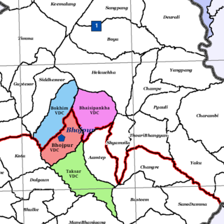
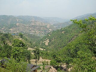
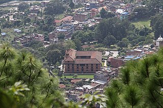
Bhojpur is a neighborhood in Bhojpur Municipality which is located in Bhojpur District in Province No. 1 of Nepal. The Bhojpur Village Panchayat was established in 1962 and was renamed as Bhojpur Village development committee in 1990.

