Senegambia Bridge | |
---|---|
Coordinates | 13°30′59″N15°34′21″W / 13.51639°N 15.57250°W |
Carries | Trans-Gambia Highway and Highway N4 |
Crosses | Gambia River |
Locale | Bamba Tenda, Gambia and Yelitenda, Gambia |
Other name(s) | Trans-Gambia Bridge |
Maintained by | National Roads Authority [1] |
Characteristics | |
Total length | 1.9 kilometres (1.2 mi) |
Width | 12 metres (39 ft) |
Longest span | 100 metres (110 yd) |
History | |
Designer | BCEOM and SCET Tunisie |
Constructed by | Isolux Corsán and the Arezki Group |
Construction cost | US$ 93 million |
Opened | January 21, 2019 |
Statistics | |
Toll | US$ 5 for cars |
Location | |
The Senegambia bridge, also known as the Trans-Gambia Bridge, is a bridge in The Gambia that carries the Trans-Gambia Highway connecting northern and southern Gambia. It also provides access to the isolated Casamance province from the rest of Senegal. A bridge had been proposed for this location in 1956 but political considerations delayed construction which finally began in 2015. Construction was funded largely by a loan of US$ 65 million from the African Development Bank, with remaining funding coming from the Gambian government. Construction works were carried out by a joint venture of Spanish company Isolux Corsán and the Senegalese Arezki Group.
The bridge, made from reinforced concrete, opened to light vehicles on 21 January 2019. At 1.9 kilometres (1.2 mi) in length it is one of West Africa's longest bridges and includes a 100-metre-wide (110 yd) central span to facilitate continued use of the river by boats. The Senegambia bridge forms part of the Trans-Gambia Highway and the Trans–West African Coastal Highway.
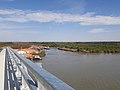
The bridge lies approximately 10 kilometres (6 mi) south of Farafenni, a Gambian town on the border with Senegal, and carries the Trans-Gambia Highway across the Gambia River, [2] which runs east-west through The Gambia and splits the country in two. The river also prevents easy movement of people from the main portion of Senegal, which lies north of The Gambia, to its southern province of Casamance which is south of the river. [3] Travellers had previously used a ferry crossing at this location, but it was unreliable and delays of 10–20 days waiting for a ferry were not uncommon. [3] [4] The alternative was a 400-kilometre (250 mi) detour eastwards to the next available crossing of the Gambia River. [4] Development in Casamance had been hindered by the poor access to the rest of the country. [2]
The bridge was first mooted in 1956 and the French government committed funds for its construction in 1971 but the start of works was delayed by periods of strained tensions between Gambia and Senegal. [3] [5] The project was formerly led by the Organisation pour la Mise en Valeur du Fleuve Gambie (OMVG) which commissioned engineering feasibility studies of the scheme from French firm BCEOM and Tunisian firm SCET Tunisie in the 1990s. [1] These studies were updated by the same companies between 2007 and 2009 and form the basis of the current design which has a 100-year design life. [1] [6]
Funding was finally secured through the African Development Fund (ADF) of the African Development Bank (ADB), which contributed US$ 65 million as lead lender for the project. [7] [8] The remaining funding was approved for the project by the Alliance for Patriotic Reorientation and Construction government of Gambia; who state that no contribution was made by Senegal. [9] Approval to proceed was granted by the government of Gambia in 2011. [6]
Final design and planning work commenced in 2012 and construction began in 2015. [2] [3] Construction was led by a joint-venture of Spanish company Isolux Corsán and the Senegalese Arezki Group. The construction contract had a value of 51.7 million euros. [10]
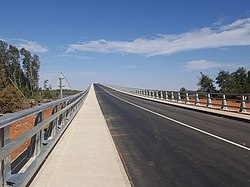
The structure is made of reinforced concrete and has a total length of 1.9 kilometres (1.2 mi) – of which the section that crosses the river is 942 metres (1,030 yd) long. [2] [3] [6] It has piled foundations but unexpectedly thick layers of mud (up to 20 metres (66 ft) in depth) on the river banks caused delays in construction. [11] It is one of the longest bridges in West Africa and incorporates a 100-metre-wide (110 yd) central span to allow for passage of boats along the river. [7] [10] The bridge deck is 12 metres (39 ft) wide and carries a 7.5-metre-wide (25 ft) single-carriageway road. [12]
The bridge's official name is a portmanteau of the names of Senegal and Gambia and is intended to reflect the bonds of friendship between the two countries, but it is also known as the Trans-Gambia Bridge. [11] [13] Total project costs were $93 million. [6] A large portion of the workforce were local: 58 % were Gambians and 20 % were from the wider ECOWAS countries. [11]
The bridge's opening ceremony took place on 21 January 2019 and was led by Gambia's President Adama Barrow and Senegal's President Macky Sall who made the first official crossing of the bridge together shortly after 4:30 p.m. local time. [3] [14] Gambian Vice President Fatoumata Tambajang, the minister of works Bai Lamin Jobe and his Senegalese counterpart Abdoulaye Daouda Diallo were also in attendance. [13] [15] Zinguinchor mayor Abdoulaye Baldé and Senegalese national football team coach Aliou Cissé were also present and Senegalese musician Youssou Ndour performed music at the opening ceremony. [3] [15]
The bridge forms part of a link on the proposed Trans–West African Coastal Highway, part of the Trans-African Highway network. [1] This project, spearheaded by the New Partnership for Africa's Development seeks to link Nouakchott in Mauritania with Lagos in Nigeria via a 15-country, 4,560-kilometre (2,830 mi) highway in the hope of boosting trade and co-operation in the region. [16]
It is hoped that the road will improve co-operation between Gambia and Senegal and facilitate trade in minerals, fuels and foodstuffs. [7] [13] It has had a marked effect on journey times; a trip by road from Dakar to Ziguinchor which previously took a day can now be completed within five hours. [3] Local ferry operators and roadside vendors have complained about the loss of revenue following construction of the bridge. [17]
There is a dispute between the Gambia Ferries Service and the National Roads Authority over which government agency is entitled to the revenue from the bridge. The Ministry of Works, Transport and Infrastructure has negotiated a temporary arrangement whereby the revenue is split between the two. The Gambian press has criticised the government for failing to set up a public–private partnership to ensure tolls fund the future maintenance of the structure. [18]
Senegal, officially the Republic of Senegal, is the westernmost country in West Africa, situated on the Atlantic Ocean coastline. Senegal is bordered by Mauritania to the north, Mali to the east, Guinea to the southeast and Guinea-Bissau to the southwest. Senegal nearly surrounds The Gambia, a country occupying a narrow sliver of land along the banks of the Gambia River, which separates Senegal's southern region of Casamance from the rest of the country. Senegal also shares a maritime border with Cape Verde. Senegal's economic and political capital is Dakar.
The history of Senegal is commonly divided into a number of periods, encompassing the prehistoric era, the precolonial period, colonialism, and the contemporary era.
Senegal's first President, Léopold Senghor, advocated close relations with France and negotiation and compromise as the best means of resolving international differences after Senegal's independence from its status as a French colony. To a large extent, the two succeeding presidents, Abdou Diouf and Abdoulaye Wade, have carried on Senghor's policies and philosophies. Senegal has long supported functional integration among French-speaking West African states through the West African Economic and Monetary Union.
The system of transportation in the Gambia mixes both public and private operations and consists of a system of roads, water and air transportation. The Trans-Gambia Highway runs along both sides of the river Gambia, which bisects the country. The river may be crossed by ferry or the Senegambia bridge. There are no railways in the country.
The Kingdom of Saloum was a Serer kingdom in present-day Senegal as well as Gambia, then called Lower Saluum. The precolonial capital of Saloum was the city of Kahone. It was a sister to the Kingdom of Sine. Their history, geography and culture were intricately linked and it was common to refer to them as the Sine-Saloum and the Serer Kingdoms of Sine and Saloum.
The Senegambia is, in the narrow sense, a historical name for a geographical region in West Africa, named after the Senegal River in the north and the Gambia River in the south. However, there are also text sources which state that Senegambia is understood in a broader sense and equated with the term the Western region. This refers to the coastal areas between Senegal and Sierra Leone, where the inland border in the east was not further defined.
The Gambia River is a major river in West Africa, running 1,120 kilometres (700 mi) from the Fouta Djallon plateau in north Guinea westward through Senegal and The Gambia to the Atlantic Ocean at the city of Banjul. It is navigable for about half that length.
Macky Sall is a Senegalese politician who served as the fourth president of Senegal from 2012 to 2024. He previously served as the eighth prime minister from 2004 to 2007, under President Abdoulaye Wade and president of the National Assembly from 2007 to 2008.
Senegambia, officially the Senegambia Confederation or Confederation of Senegambia, was a loose confederation in the late 20th century between the West African countries of Senegal and its neighbour The Gambia, which is almost completely surrounded by Senegal. The confederation was founded on 1 February 1982 following an agreement between the two countries signed on 12 December 1981. It was intended to promote cooperation between the two countries, but was dissolved by Senegal on 30 September 1989 after The Gambia refused to move closer toward union. The Senegambia Confederation should not be confused with the historic Senegambia region, generally shortened to the Senegambia.
The Casamance conflict is an ongoing low-level conflict that has been waged between the Government of Senegal and the Movement of Democratic Forces of Casamance (MFDC) since 1982. On May 1, 2014, the leader of the MFDC sued for peace and declared a unilateral ceasefire.
Farafenni or Farafegni is a town in the Gambia, lying on the Trans-Gambia Highway in the North Bank Division, just south of the border with Senegal. It is an important market town.
MV Le Joola was a Senegalese government-owned roll-on/roll-off ferry that capsized off the coast of The Gambia on 26 September 2002, with 1,863 deaths and 64 survivors. It is thought to be the second-worst peacetime disaster in maritime history.
The Trans-Gambia Highway is a major highway in The Gambia, running across the centre of the nation in a north–south direction.
Radiodiffusion Télévision Sénégalaise (RTS) is the Senegalese public broadcasting company.
Carabane, also known as Karabane, is an island and a village located in the extreme south-west of Senegal, in the mouth of the Casamance River. This relatively recent geological formation consists of a shoal and alluvium to which soil is added by accumulation in the branches and roots of the mangrove trees which cover most of the island. Along with the rest of Ziguinchor Region, Carabane has a tropical climate, cycling between a dry season and a wet season. The island was once considered an arid location where no useful plants were likely to grow, but it now supports several types of fruit tree, the most common of which are mangos and oranges. Although the nearby Basse Casamance National Park and Kalissaye Avifaunal Reserve have been closed for years because of the Casamance Conflict, Carabane has continued to attract ornithologists interested in its wide variety of birds. Various species of fish are plentiful around the island, but there are very few mammals.
Presidential elections were held in Senegal on 26 February 2012, amidst controversy over the constitutional validity of a third term for incumbent president Abdoulaye Wade. In the runoff on 25 March, Macky Sall defeated the incumbent president. The 2015 documentary film Incorruptible chronicles both campaigns as well as the youth movement Y'en a Marre, which led protests against Wade's administration.
The N4 road is one of the 7 national roads in Senegal. It connects central-Senegal with Basse Casamance by a route which crosses The Gambia.
Ziguinchor is the capital of the Ziguinchor Region, and the chief town of the Casamance area of Senegal, lying at the mouth of the Casamance River. It has a population of 214,874. It is the eighth largest city of Senegal, but is nearly separated from the north of the country by the nation of The Gambia.
Musa Ngum was a singer and songwriter who was very popular in Senegal and Gambia. He was one of the pioneers of mbalax music, and "helped to define the mbalax style of popular music in the Senegambia" and "had a strong influence on Youssou N'Dour and other mbalax pioneers". He was "something of a cult icon back in the Senegambia region, and a pioneer of the mbalax fusion style". The mbalax, which originated from the Serer religious and ultra–conservative njuup music tradition sang during Ndut rites by circumcised boys was the foundation of Ngum's music career. He mastered many of the njuup classics and built a name for himself while at the same time developing his voice.
The Diamniadio Olympic Stadium, also known as the Stade Me. Abdoulaye Wade is a multi-purpose stadium, which can host football, rugby and athletics, in Diamniadio, in Dakar, Senegal. It is the national stadium of the Senegal national football team. The stadium which has a capacity of 50,000 designed by Tabanlıoğlu Architects and built by Summa. It will host the 2026 Summer Youth Olympics.
{{cite news}}
: CS1 maint: unfit URL (link)