Related Research Articles
Sakhalin Gulf is a gulf in the Sea of Okhotsk between continental Russia and the Schmidt Peninsula, at the northern tip of Sakhalin Island. The width of the gulf reaches up to 160 km (99 mi). It is covered with ice from mid-November until late April, but north winds can leave the bay blocked with ice until July.

The Shantar Islands are a group of fifteen islands located off the northwestern shore of the Sea of Okhotsk east of Uda Gulf and north of Academy Bay. Most of the islands have rugged cliffs, but they are of moderate height; the highest point in the island group is 720 metres. The name of the island group has its origins in the Nivkh language from the word ч’андь č’and’ meaning "to be white".
Bolshoy Shantar is the main island of the Shantar Islands in the Sea of Okhotsk, Russia; its area is 1,766 square kilometres and it measures about 72 by 49 km. It has a large brackish lake on its north side which is connected to the sea through a narrow passage. Yakshin Bay indents the southwest side of the island.

Feklistova or Feklistov Island is one of the Shantar Islands in Sea of Okhotsk. With an area of 372 square kilometres, it is the second largest in the archipelago.
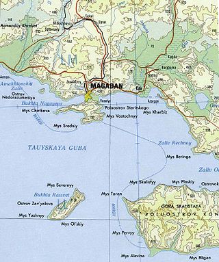
Nedorazumeniya Island is an island on the north coast of the Sea of Okhotsk. It lies on the north side of Taui Bay, between Amakhton Bay to the west and Nagaev Bay to the east. It is about 20 kilometres (12 mi) west of the city of Magadan.

Taui Bay is a body of water in the Sea of Okhotsk off the coast of the Magadan Oblast in Russia. The bay opens to the south.
Konstantina Bay is a small bay in the northwestern Sea of Okhotsk, just south of the Shantar Islands. It is a western branch of the larger Academy Bay to the east. The bay is about 9.6 km (6 mi) in diameter and its entrance is about 4.8 km (3 mi) wide. Spring tides rise 3.8 m (12.5 ft), while neaps rise 2.7 m (9 ft).
Ulban Bay is a bay in the northwestern Sea of Okhotsk, just south of the Shantar Islands. It is a southern branch of Academy Bay to the north. The Syran and Ulban rivers flow into its head.
Tugur Bay or Tugursky Bay is a large bay in the Tuguro-Chumikansky District of Khabarovsk Krai, Russian Federation.
Maly Shantar Island is a small, narrow island in the northwestern Sea of Okhotsk, one of the Shantar Islands.
Medvezhy Island is a long, narrow island in the northwestern Sea of Okhotsk, the westernmost of the Shantar Islands. It lies on the eastern side of Uda Gulf. It is 12.9 km long. It is separated from the mainland by Shevchenko Straight.
Prokofyeva is a small island in the Sea of Okhotsk. It is one of the Shantar Islands. It lies to the northeast of Bolshoy Shantar Island.

Lindholm Strait is a strait in the northwestern Sea of Okhotsk. It separates Malyy Shantar and Belichiy Islands to the north from the Tugur Peninsula to the south. At its narrowest it is only 3.2 km wide. Tides are semidiurnal. Springs rise 4.9 m, while neaps rise 3.6 m. The flood current sets west, while the stronger ebb current flows in the opposite direction. The former creates large eddies and whirlpools. Tidal currents vary from 3.5 to 6 knots.
Academy Bay is a large bay in the Tuguro-Chumikansky District of Khabarovsk Krai, Russian Federation.
Lebyazhya Bay is a small bay that indents the south side of Feklistova Island, one of the Shantar Islands, in the western Sea of Okhotsk. Its entrance is 11.3 kilometers (7.0 mi) wide and it is 5.6 kilometers (3.5 mi) deep. There are three small bays at its head: Enegelma Road to the west, Soboleva to the north, and Rosseta to the east. A small island, Sukhotina, lies to its southeast. In the spring and summer it is host to a small nesting colony of thick-billed murre. A number of streams of fresh water flow down the hills into the bay. Spring tides rise 6.5 meters (21 ft) while neaps rise 2.4 meters.
Abrek Bay is a small bay on the southeast coast of Maly Shantar Island, one of the Shantar Islands, in the western Sea of Okhotsk. It is 2.4 km (1.5 mi) wide at its entrance and about 1.6 km (1 mi) deep. Spring tides rise about 4.5 m (15 ft) and neaps about 2.7 m (9 ft).
Cape Ukurunru is a cape in the western Sea of Okhotsk. It has sheer cliffs that are grayish-brown in color. It forms the western point to the entrance of Ulban Bay.
Yakshin Bay is a small bight in the western Sea of Okhotsk. It is 29 km wide and indents the southwest side of Bolshoy Shantar Island. The bay is entered between Capes Raduzhnyy to the west and Filippa to the east. The Yakshin River flows into the head of the bay. There is ice in the bay from December to July. Tides rise 4.9 m (16 ft) at springs, with the flood current flowing in a counterclockwise direction round the bay and the ebb in the reverse direction. These tidal currents may reach 3.5 to 4 knots near the entrance of the bay but are less than 2 knots at its head.

Utichy Island is a small island in the western Sea of Okhotsk. It is one of the Shantar Islands. It lies southwest of the southwest point of Bolshoy Shantar Island and northeast of Ptichy Island.
Severnyy Strait is a strait in the western Sea of Okhotsk. It separates two of the Shantar Islands: Feklistova Island to the west and Bolshoy Shantar Island to the east.
References
- ↑ National Geospatial-Intelligence Agency. (2014). Sailing Directions (Enroute): East Coast of Russia. U.S. Government, Springfield, Virginia.
- ↑ Mary Frazier, of New Bedford, 2 July 1855, Nicholson Whaling Collection (NWC); Mary Frazier, of New Bedford, 14 July 1858, NWC; Sea Breeze, of New Bedford, 17 July 1874, George Blunt White Library.
54°19′N137°44′E / 54.317°N 137.733°E
| | This Khabarovsk Krai location article is a stub. You can help Wikipedia by expanding it. |