Seok Pass

Last updated
Seok Pass
Söök Pass
Relief Map of Kyrgyzstan.png
Red pog.svg
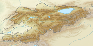
Location in Kyrgyzstan
Elevation 4,028 m (13,215 ft)
Location Kyrgyzstan
Range Tian Shan
Coordinates 41°44′53.7″N77°47′20.7″E / 41.748250°N 77.789083°E / 41.748250; 77.789083 Coordinates: 41°44′53.7″N77°47′20.7″E / 41.748250°N 77.789083°E / 41.748250; 77.789083

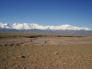
Seok Pass, Söök Pass or Suyak Pass (Russian : перевал Сёок, Kyrgyz : Сөөк ашуусу) is a mountain pass in the Terskey Alatau mountain range of Kyrgyzstan. Its elevation of 4,028 metres (13,220 ft) makes it the third highest mountain pass in Kyrgyzstan after Bedel Pass and Kyzylart Pass, and the highest one that is not on a border. It connects the Ala-Bel plateau, where the Kumtor Gold Mine is located, to the upper Naryn River valley.

Russian language East Slavic language

Russian is an East Slavic language, which is official in the Russian Federation, Belarus, Kazakhstan and Kyrgyzstan, as well as being widely used throughout Eastern Europe, the Baltic states, the Caucasus and Central Asia. It was the de facto language of the Soviet Union until its dissolution on 25 December 1991. Although, nowadays, over two decades after the breakup of the Soviet Union, Russian is used in official capacity or in public life in all the post-Soviet nation-states, as well as in Israel and Mongolia, the rise of state-specific varieties of this language tends to be strongly denied in Russia, in line with the Russian World ideology.

Kyrgyz is a Turkic language spoken by about four million people in Kyrgyzstan as well as China, Afghanistan, Kazakhstan, Tajikistan, Turkey, Uzbekistan, Pakistan and Russia. Kyrgyz is a member of the Kyrgyz–Kipchak subgroup of the Kypchak languages, and modern-day language convergence has resulted in an increasing degree of mutual intelligibility between Kyrgyz and Kazakh.

Terskey Alatau mountain range in Kyrgyzstan

The Terskey Alatau or Terskey Ala-Too is a mountain range in the Tian Shan mountains in Kyrgyzstan. It stretches south and southeast of Lake Issyk Kul, from the river Joon Aryk near Kochkor in the west to the far northeastern part of Kyrgyzstan. The length of the range is 354 km and the highest peak is Karakol Peak. Another high peak is Boris Yeltsin Peak.

The A364 road at Seok Pass, facing southeast Seok Pass view east.jpg
The A364 road at Seok Pass, facing southeast

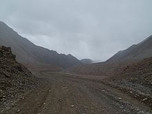
Seok Pass is situated on the ancient Silk Road route connecting Barskon on Lake Issyk-Kul and Kashgar in China's Xinjiang province across the Tian Shan mountains. It is one of three major passes on this route, located between Barskoon Pass (elevation 3,819 metres [12,530 ft]) and Bedel Pass (elevation 4,284 metres [14,060 ft]). As the border road over Bedel Pass to China has remained closed since Soviet times, Seok Pass is nowadays significant mainly as a strategic gateway on the A364 road to the southeastern high mountain desert areas of Kyrgyzstan along the Chinese border, and to the border posts at Kara-Say and Ak-Shyrak.

Silk Road trade routes through Asia connecting Chinza to the Mediterranean Sea

The Silk Road was an ancient network of trade routes that connected the East and West. It was central to cultural interaction between the regions for many centuries. The Silk Road primarily refers to the terrestrial routes connecting East Asia and Southeast Asia with East Africa, West Asia and Southern Europe.

Issyk-Kul Lake in Kyrgyzstan

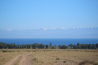
Issyk-Kul is an endorheic lake in the northern Tian Shan mountains in eastern Kyrgyzstan. It is the seventh deepest lake in the world, the tenth largest lake in the world by volume, and the second largest saline lake after the Caspian Sea. Issyk-Kul means "warm lake" in the Kyrgyz language; although it is surrounded by snow-capped peaks, it never freezes.

Kashgar County-level city in Xinjiang, Peoples Republic of China

Kashgar, officially known as Kashi, is an oasis city in Xinjiang, People's Republic of China. It is one of the westernmost cities of China, near the border with Afghanistan, Kyrgyzstan, India and Tajikistan. With a population of over 500,000, Kashgar has served as a trading post and strategically important city on the Silk Road between China, the Middle East, and Europe for over 2,000 years.

Roadside marker at Seok Pass, altitude 4,028 metres (13,220 ft) Seok Pass mountain pass sign.jpg
Roadside marker at Seok Pass, altitude 4,028 metres (13,220 ft)

The name means "Bone Pass" in Kyrgyz, a reference to the Urkun incident of 1916, when thousands of Kyrgyz died attempting to cross the border into China, fleeing from Tsarist Russian forces.

The Kyrgyz people are a Turkic ethnic group native to Central Asia, primarily Kyrgyzstan.

Tsar title given to a male monarch in Russia, Bulgaria and Serbia

Tsar, also spelled czar, or tzar, is a title used to designate East and South Slavic monarchs or supreme rulers of Eastern Europe, originally Bulgarian monarchs from 10th century onwards. As a system of government in the Tsardom of Russia and the Russian Empire, it is known as Tsarist autocracy, or Tsarism. The term is derived from the Latin word Caesar, which was intended to mean "Emperor" in the European medieval sense of the term—a ruler with the same rank as a Roman emperor, holding it by the approval of another emperor or a supreme ecclesiastical official —but was usually considered by western Europeans to be equivalent to king, or to be somewhat in between a royal and imperial rank.

The condition of the pass can be seen using Google Maps satellite imagery.

Related Research Articles

Geography of Kyrgyzstan

Kyrgyzstan is a landlocked nation in Central Asia, west of the People's Republic of China. Less than a seventh the size of Mongolia, at 199,951 square kilometers, Kyrgyzstan is one of the smaller Central Asian states. The national territory extends about 900 km (560 mi) from east to west and 410 km (250 mi) from north to south.

Lenin Peak mountain in Kyrgyzstan

Lenin Peak, or Ibn Sina (Avicenna) Peak, rises to 7,134 metres (23,406 ft) in Gorno-Badakhshan (GBAO) on the border of Tajikistan and Kyrgyzstan, and is the second-highest point of both countries. It is considered one of the less technical 7000 m peaks in the world to climb and it has by far the most ascents of any 7000 m or higher peak on Earth, with every year seeing hundreds of mountaineers make their way to the summit. Lenin Peak is the highest mountain in the Trans-Alay Range of Central Asia, and in the Pamir Mountains in Tajikistan it is exceeded only by Ismoil Somoni Peak. It was thought to be the highest point in the Pamirs in Tajikistan until 1933, when Ismoil Somoni Peak was climbed and found to be more than 300 metres higher. Two mountains in the Pamirs in China, Kongur Tagh and Muztagh Ata, are higher than the Tajik summits.

Tian Shan system of mountain ranges located in Central Asia

The Tian Shan, also known as the Tengri Tagh, meaning the Mountains of Heaven or the Heavenly Mountain, is a large system of mountain ranges located in Central Asia. The highest peak in the Tian Shan is Jengish Chokusu, at 7,439 metres (24,406 ft) high. Its lowest point is the Turpan Depression, which sits at 154 m (505 ft) below sea level.

Torugart Pass mountain pass

Torugart Pass is a mountain pass in the Tian Shan mountain range near the border between the Naryn Province of Kyrgyzstan and the Xinjiang Autonomous Region of China. It is one of two border crossings between Kyrgyzstan and China, the other being Irkeshtam, some 165 km (103 mi) to the southwest.

Pamir Mountains mountain range

The Pamir Mountains are a mountain range in Central Asia, at the junction of the Himalayas with the Tian Shan, Karakoram, Kunlun, Hindu Kush, Suleman and Hindu Raj ranges. They are among the world’s highest mountains.

Alay Mountains mountain range in Central Asia

The Alay or Alai Mountains constitute a mountain range that extends from the Tien Shan mountain range in Kyrgyzstan west into Tajikistan. It is part of the Pamir-Alai mountain system. The range runs approximately east to west. Its highest summit is Pik Tandykul, 5544 m. The southern slopes of the range drain into the Vakhsh River, a tributary of the Amu Darya. The streams that drain the northern slopes of the range are tributaries of the Syr Darya, and empty into the Fergana Valley to the north of the range.

Jengish Chokusu mountain in Kyrgyzstan

Jengish Chokusu is the highest mountain in the Tian Shan mountain system at 7,439 metres (24,406 ft). It lies on the Kyrgyzstan–China border between the raion of Ak-Suu, in the Issyk-Kul Region of far eastern Kyrgyzstan and Wensu County, Xinjiang, China. It is part of the Kakshaal Too, the highest part of the Tian Shan, and located southeast of lake Issyk Kul.

Balykchy Place in Issyk-Kul Region, Kyrgyzstan

Balykchy is a town at the western end of Lake Issyk-Kul in Kyrgyzstan, at an elevation of about 1,900 metres. Its area is 38 square kilometres (15 sq mi), and its resident population was 42,875 in 2009. A major industrial and transport centre during the Soviet era, it lost most of its economic base after the collapse of the Soviet Union and the closure of virtually all of its industrial facilities.

Issyk-Kul Region Region in Kyrgyzstan

Issyk-Kul Region is one of the regions of Kyrgyzstan. Its capital is Karakol. It is surrounded by Almaty Region, Kazakhstan (north), Chuy Region (west), Naryn Region (southwest) and Xinjiang, China (southeast). It takes its name from Lake Issyk-Kul, the second largest saline lake in the world, which never freezes despite its altitude in the Tian Shan mountains.

Khan Tengri mountain in Kyrgyzstan

Khan Tengri is a mountain of the Tian Shan mountain range. It is located on the China—Kyrgyzstan—Kazakhstan border, east of lake Issyk Kul. Its geologic elevation is 6,995 m (22,949 ft), but its glacial cap rises to 7,010 m (22,999 ft). For this reason, in mountaineering circles, including for the Soviet Snow Leopard award criteria, it is considered a 7,000-metre peak. The name "Khan Tengri" literally means "King Heaven" in Kazakh and possibly references the deity Tengri. In some other local languages, it is known as Khan Tangiri Shyngy, Kan-Too Chokusu, Pik Khan-Tengry, and Hantengri Feng.

Trans-Alay Range mountain range

The Trans-Alay Range is the northernmost range of the Pamir Mountain System.

Ala Archa National Park alpine national park in the Tian Shan mountains of Kyrgyzstan

The Ala Archa National Park is an alpine national park in the Tian Shan mountains of Kyrgyzstan, established in 1976 and located approximately 40 km south of the capital city of Bishkek.

Barskoon Place in Issyk-Kul Region, Kyrgyzstan

Barskoon, Barskon or Barskaun, ancient Barsgan, Barskhan or Barsqan is a settlement on the southern shore of Lake Issyk Kul in the Issyk-Kul Region of Kyrgyzstan. Its population was 6,912 in 2009. It is on the A363 highway between Bokonbayevo to the west and Kyzyl-Suu to the east.

Bedel Pass

Bedel Pass is a mountain pass in the Tian-Shan mountain range between Kyrgyzstan and China's Xinjiang province. It has an elevation of 4,284 metres (14,055 ft). The pass linked China to Barskon, a settlement on the southern shore of lake Issyk-kul.

Chatyr-Kul lake

Chatyr-Kul is an endorheic alpine lake in the Tian Shan mountains in At-Bashi District of Naryn Province, Kyrgyzstan; it lies in the lower part of Chatyr-Kul Depression near the Torugart Pass border crossing into China. The name of the lake means “Celestial Lake” in Kyrgyz. The lake and 2 km buffer zone around it is part of the Karatal-Japyryk State Nature Reserve. The lake is a Ramsar site of globally significant biodiversity.

Kirghiz Soviet Socialist Republic union republic of the Soviet Union

Kirghizia, officially the Kirghiz Soviet Socialist Republic and the Republic of Kirghizia, also referred to as Soviet Kirghizia, was one of the constituent republics of the Soviet Union (USSR) from 1936 to 1991.

Erkeshtam Place in Osh Region, Kyrgyzstan

Erkeshtam, also Irkeshtam or Erkech-Tam, is a border crossing between Kyrgyzstan and Xinjiang, China, named after a village on the Kyrgyz side of the border in southern Osh Region. The border crossing is also called Simuhana (斯姆哈纳), after the first settlement on the Chinese side of the border, but Erkeshtam is now the more common name used in both countries.

Töö Ashuu Mountain pass in Kyrgyzstan

Töö Ashuu, literally "camel pass", is a mountain pass in Kyrgyzstan on the highway from Bishkek to Osh in Kyrgyzstan approximately 120 km from Bishkek. The pass goes over part of the Kyrgyz Alatau range of the Tien Shan mountains. A 2.7-kilometre-long (1.7 mi) road tunnel enters the mountain at 3130 m on the north side and comes out at 3180 m on the south side. The old pass over the mountain at this point was around 3500 m and thus this road pass is often described as reaching this height.

China–Kyrgyzstan border divides the territories of Kyrgyzstan and China

The China-Kyrgyzstan border is 1,063km (660m) in length and runs from the tripoint with Kazakhstan following a roughly south-west line across various mountain ridges and peaks of the Tian Shan range down to the tripoint with Tajikistan.

References