Seraya

Last updated
Seraya
Saraya Building Nazareth 014.JPG
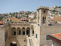
General view of the Seraya, 2010
Israel location map with stripes.svg
Red pog.svg
Location within Israel
General information
StatusVacant
TypeGovernment Palace
Architectural style Ottoman, neoclassical
Location Nazareth, Israel
Coordinates 32°42′13.77″N35°17′54.3012″E / 32.7038250°N 35.298417000°E / 32.7038250; 35.298417000
Completed1740
OwnerNazareth Municipal Council
Known forHeadquarters of Nazareth City Council (1877-1991)
Residence of Nazareth Governor (1740-1877)
Summer Residence of Zahir al-Umar

The Seraya (also spelled Saraya) is a historical building in Nazareth, Israel. It was built around 1740 (or 1730 [1] by the autonomous Arab ruler of the Galilee, Zahir al-Umar, during the Ottoman era in Palestine. [2] Zahir, who later based himself in Acre, used it as a summer home. [1] The Seraya served other functions, namely that of a governmental headquarters for Nazareth, which was an important town in the area and protected the routes and agricultural lands of the Jezreel Valley. The Seraya contained a stable for horses and a jail. Moreover, because of the absence of mosques in Nazareth at the time of the Seraya's construction, Zahir designated a prayer room to substitute for a mosque to serve the town's Muslim residents. It continued in this capacity until the nearby White Mosque was completed in 1812. [2]

In 1857, [3] a portico was built for the Seraya, [2] amid other renovations. [3] Later, in the early 20th century, a watchtower, built in the European Renaissance style, was added to the building. With the establishment of the Nazareth Municipal Council in 1877, the Seraya served as the council's headquarters until 1991. Prior to that it served as the residence of the local governor of Nazareth and its subdistrict. [2] It is currently in disuse, but the city plans to turn the Seraya into a museum. [2] [1]

Related Research Articles

<span class="mw-page-title-main">Nazareth</span> Largest city in the Northern District of Israel

Nazareth is the largest city in the Northern District of Israel. In 2022 its population was 78,007. Nazareth serves as a cultural, political, religious, economic and commercial center for the Arab citizens of Israel. Known as "the Arab capital of Israel", it is also a center of Arab and Palestinian nationalism. The inhabitants are predominantly Arab citizens of Israel, of whom 69% are Muslim and 30.9% Christian. The city also commands immense religious significance, deriving from its status as the hometown of Jesus, the central figure of Christianity.

<span class="mw-page-title-main">Al-Aqsa Mosque</span> Main Islamic prayer hall at the Al-Aqsa Mosque compound in Jerusalem

The Aqsa Mosque, also known as the Qibli Mosque or Qibli Chapel, is the main congregational mosque or prayer hall in the Al-Aqsa mosque compound in the Old City of Jerusalem. In some sources the building is also named al-Masjid al-Aqṣā, but this name primarily applies to the whole compound in which the building sits, which is itself also known as "Al-Aqsa Mosque". The wider compound is known as Al-Aqsa or Al-Aqsa mosque compound, also known as al-Ḥaram al-Sharīf.

<span class="mw-page-title-main">Tiberias</span> City in northern Israel

Tiberias is an Israeli city on the western shore of the Sea of Galilee. A major Jewish center during Late Antiquity, it has been considered since the 16th century one of Judaism's Four Holy Cities, along with Jerusalem, Hebron, and Safed. In 2022, it had a population of 48,472.

<span class="mw-page-title-main">Sha'ab, Israel</span> Local council in Israel

Sha'ab is an Arab town and local council in the Northern District of Israel. It has an area of 5,442 dunams of land under its jurisdiction. In 2022 its population was 7,469.

Nof HaGalil City in Israel

Nof HaGalil is a city in the Northern District of Israel with a population of 44,184.

<span class="mw-page-title-main">Safed</span> City in northern Israel

Safed is a city in the Northern District of Israel. Located at an elevation of up to 937 m (3,074 ft), Safed is the highest city in the Galilee and in Israel. It is known as the "capital" of the Galilee.

<span class="mw-page-title-main">Shefa-Amr</span> City in Israel

Shefa-Amr or Shfar'am is an Arab city in the Northern District of Israel. In 2022 it had a population of 43,543, with a Sunni Muslim majority and large Christian Arab and Druze minorities.

<span class="mw-page-title-main">Hittin</span> Place in Tiberias, Mandatory Palestine

Hittin was a Palestinian village located 8 kilometers (5 mi) west of Tiberias before it was occupied by Israel during the 1948 Arab-Israeli war when most of its original residents became refugees. As the site of the Battle of Hattin in 1187, in which Saladin reconquered most of Palestine from the Crusaders, it has become an Arab nationalist symbol. The shrine of Nabi Shu'ayb, venerated by the Druze and Sunni Muslims as the tomb of Jethro, is on the village land. The village was ruled by the Ottoman Empire from the 16th century until the end of World War I, when Palestine became part of the British Mandate for Palestine. On July 17 1948, the village was occupied by Israel, after its residents fled out of their homes because of Nazareth's occupation. in later years, the Moshavs Arbel and Kfar Zeitim were erected where Hittin used to be.

<span class="mw-page-title-main">Seraglio</span> Admin buildings in the former Ottoman Empire

A seraglio, serail, seray or saray is a castle, palace or government building which was considered to have particular administrative importance in various parts of the former Ottoman Empire.

Saray, or seray, is a Turkish word from Persian: سرای, romanized: sarāy, lit.'palace', traditionally translated as serail or seraglio via Italian influence. The term is usually referred to:

<span class="mw-page-title-main">Zahir al-Umar</span> Arab ruler of northern Palestine (1689/90–1775)

Zahir al-Umar al-Zaydani, alternatively spelled Daher al-Omar or Dahir al-Umar, was an Arab ruler of northern Palestine in the mid-18th century, while the region was part of the Ottoman Empire. For much of his reign, starting in the 1730s, his domain mainly consisted of the Galilee, with successive headquarters in Tiberias, Deir Hanna and finally Acre, in 1750. He fortified Acre, and the city became the center of the cotton trade between Palestine and Europe. In the mid-1760s, he reestablished the port town of Haifa nearby.

<span class="mw-page-title-main">Emile Habibi</span> Palestinian-Israeli writer of Arabic literature and politician (1922-1996)

Emile Shukri Habibi was a Palestinian-Israeli writer of Arabic literature and a politician who served as a member of the Knesset for the communist parties Maki and Rakah.

<span class="mw-page-title-main">Deir Hanna</span> Local council

Deir Hanna is a local council in the Northern District of Israel, located on the hills of the Lower Galilee, 23 kilometres (14 mi) southeast of Acre. In 2022 it had a population of 10,747. Approximately 90% of Deir Hanna's inhabitants are Arab-Muslims and the remaining 10% are Arab-Christians.

<span class="mw-page-title-main">I'billin</span> Local council in Northern Israel

I'billin is a local council in the Northern District of Israel, near Shefa-'Amr. 'Ibillin was granted municipal status in 1960. The municipality's area is 18,000 dunams. In 2022 its population was 13,843, all of whom are Arab Israelis with a mixed population of Muslims and Christians.

<span class="mw-page-title-main">Arraba, Israel</span> City in Israel

Arraba, also known as 'Arrabat al-Battuf, is an Arab city in Israel. It is located in the Lower Galilee in the Northern District, within Sakhnin valley, adjacent to Sakhnin and Deir Hanna, and climbing a bit on Yodfat range to its south, while also owning some lands south of that in the Beit Netofa Valley to the north of Nazareth area. Arraba attained local council status in 1965, and city status in 2016. In 2022, its population was 27,115.

<span class="mw-page-title-main">Sanur, Jenin</span> Municipality type D in Jenin, State of Palestine

Sanur is a Palestinian village located 26 kilometres (16 mi) southwest of Jenin, in the Jenin Governorate of the State of Palestine. According to the Palestinian Central Bureau of Statistics, Sanur had a population of 4,067 in 2007 and 5,036 in 2017. During the late Ottoman era, Sanur served as a fortified village of the Jarrar family and played a key role in limiting the centralized power of the Ottoman sultanate, the Ottoman governors of Damascus and Acre and the Ottoman-aligned Tuqan family of Nablus from exerting direct authority over the rural highlands of Jabal Nablus.

<span class="mw-page-title-main">Al-Muallaq Mosque</span> Mosque in Acre, Northern, Israel

The al-Muallak Mosque also known as the Mosque of Zahir al-Umar is a mosque in Acre, Israel.

Al-Zayadina were an Arab clan based in the Galilee. They were best known after one of their sheikhs (chiefs) Zahir al-Umar, who, through his tax farms, economic monopolies, popular support, and military strength ruled a semi-autonomous sheikhdom in northern Palestine and adjacent regions in the 18th century.

Seraya or Serayah may refer to:

Saraya may refer to:

References

  1. 1 2 3 Jacobs, Daniel (1998), Israel and the Palestinian Territories, Rough Guides, p. 81, ISBN   9781858282480
  2. 1 2 3 4 5 Seraya, Nazareth Cultural and Tourism Association
  3. 1 2 "El Saraya", Nazareth 360, Astrateq Group