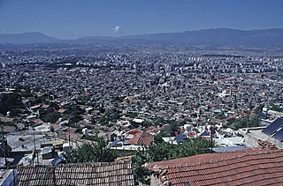
Antakya, modern form of Antioch, is a municipality and the capital district of Hatay Province, Turkey. Its area is 703 km2, and its population is 399,045 (2022). It is the capital of Hatay Province, the southernmost province of Turkey. The city is located in a well-watered and fertile valley on the Orontes River, about 20 kilometres (12 mi) from the Levantine Sea.

Harbiye is a neighbourhood of the municipality and district of Defne, Hatay Province, Turkey. Its population is 27,057 (2022). Before the 2013 reorganisation, it was a town (belde). Also in 2013, it passed from the former central district of Hatay to the new district of Defne.
Payas is a municipality and district of Hatay Province, Turkey. Its area is 157 km2, and its population is 43,919 (2022). The district Payas was created in 2013 from part of the district of Dörtyol.
Kışlak is a neighbourhood of the municipality and district of Yayladağı, Hatay Province, Turkey. Its population is 898 (2022). Before the 2013 reorganisation, it was a town (belde).
Şenköy is a neighbourhood of the municipality and district of Yayladağı, Hatay Province, Turkey. Its population is 875 (2022). Before the 2013 reorganisation, it was a town (belde). Also in 2013, it passed from the former central district of Hatay to the district of Yayladağı.
Aktepe is a neighbourhood of the municipality and district of Hassa, Hatay Province, Turkey. Its population is 8,736 (2022). Before the 2013 reorganisation, it was a town (belde).
Akbez is a neighbourhood of the municipality and district of Hassa, Hatay Province, Turkey. Its population is 10,228 (2022). Before the 2013 reorganisation, it was a town (belde).
Narlıca is a neighbourhood of the municipality and district of Antakya, Hatay Province, Turkey. Its population is 18,445 (2022). Before the 2013 reorganisation, it was a town (belde). Narlıca is 5 kilometres (3.1 mi) north east of the city center.
Kuşalanı is a neighbourhood of the municipality and district of Samandağ, Hatay Province, Turkey. Its population is 6,139 (2022). Before the 2013 reorganisation, it was a town (belde). It is on the state highway D.420 connecting Samandağ to Antakya. The distance to Samandağ is 3 kilometres (1.9 mi) and to Antakya is 22 kilometres (14 mi).
Karbeyaz is a neighbourhood of the municipality and district of Altınözü, Hatay Province, Turkey. Its population is 1,128 (2022). Before the 2013 reorganisation, it was a town (belde).
Sutaşı is a neighbourhood of the municipality and district of Samandağ, Hatay Province, Turkey. Its population is 6,402 (2022). Before the 2013 reorganisation, it was a town (belde).
Avsuyu is a neighbourhood of the municipality and district of Antakya, Hatay Province, Turkey. Its population is 5,124 (2022). Before the 2013 reorganisation, it was a town (belde). It is situated on the north coast of Yarseli Dam reservoir. It is about 29 kilometres (18 mi) north east of Antakya. Main crops of the town are olive, pepper, tobacco and cotton. There is an oil press in the town.

Denizciler is a neighbourhood of the municipality and district of İskenderun, Hatay Province, Turkey. Its population is 25,270 (2022). Before the 2013 reorganisation, it was a town (belde). It is a coastal town situated on the east coast line of the Mediterranean Sea. It is on Turkish state highway D.817 which connects İskenderun to north. The distance to İskenderun is 9 kilometres (5.6 mi) and to Antakya is 65 kilometres (40 mi).
Yeşilköy is a neighbourhood of the municipality and district of Dörtyol, Hatay Province, Turkey. Its population is 10,436 (2022). Before the 2013 reorganisation, it was a town (belde). It is situated between Nur Mountains and the Mediterranean Sea coast. Turkish state highway D.817 is to the west, Çukurova Motorway is to the east and Dörtyol is to the south of the town. Yeşilköy is almost merged to Dörtyol. The distance to Antakya is 90 kilometres (56 mi). Yeşilköy was declared a seat of township in 1968. The main agricultural crops are citrus and vegetables. The town is in a flourishing industrial area. Services to summer houses around the town also constitute a part of town revenue.
Karayılan is a neighbourhood of the municipality and district of İskenderun, Hatay Province, Turkey. Its population is 9,074 (2022). Before the 2013 reorganisation, it was a town (belde).
Gözcüler is a neighbourhood of the municipality and district of Arsuz, Hatay Province, Turkey. Its population is 6,565 (2022). Before the 2013 reorganisation, it was a town (belde). Also in 2013, it passed from the district of İskenderun to the new district of Arsuz. It is situated to the south of İskenderun and to the east of Arsuz (Uluçınar). Although not a coastal town, the distance to Mediterranean Sea coast is only 5 kilometres (3.1 mi). The distance to İskenderun is 32 kilometres (20 mi) and to Antakya is 96 kilometres (60 mi).
Bekbele is a neighbourhood of the municipality and district of İskenderun, Hatay Province, Turkey. Its population is 8,148 (2022). Before the 2013 reorganisation, it was a town (belde). It is situated mostly to the east of Çukurova Motorway and is almost merged to İskenderun. The distance to Antakya is about 80 kilometres (50 mi). The settlement was founded by a tribe named Abacılı from Dulkadir territory of the Ottoman Empire towards the end of the 18th century. According to mayor's page, Abacılı which refers to manufacturing coarse woolen cloth was a subtribe of Bayat, a Turkmen tribe.
Karakese is a neighbourhood of the municipality and district of Dörtyol, Hatay Province, Turkey. Its population is 5,994 (2022). Before the 2013 reorganisation, it was a town (belde).
Tomruksuyu is a neighbourhood of the municipality and district of Samandağ, Hatay Province, Turkey. Its population is 3,722 (2022). Before the 2013 reorganisation, it was a town (belde). It is to the north of the highway connecting Samandağ to Antakya. The distance to Samandağ is 12 kilometres (7.5 mi) and to Antakya is 15 kilometres (9.3 mi).
Soğukoluk is a neighbourhood of the municipality and district of Belen, Hatay Province, Turkey. Its population is 352 (2022).
